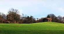
Franz's field
The Franzsche Feld , known as the SA field during the Nazi era between 1935 and the end of the war in 1945 , is a green area in the eastern ring area of the city of Braunschweig .
Background and story
The name of these green spaces goes back to the farmer Franz from Riddagshausen , who cultivated these lands below the Nussberg at the beginning of the 19th century. It means nothing else than "Franz's field." Several sports clubs have settled on the local sports facility on the edge of Jasperallee .
As early as the 16th century, the strategic location of the location for military marches or sieges of the city had become apparent. In the 19th century the fortifications were dismantled and the area was used by the ducal military of the garrison town of Braunschweig as a training ground or was used by farmers for the Riddagshausen monastery .
1930 to 1945
With the growing influence of the NSDAP and its alliance against the Weimar Republic in the Harzburg Front in October 1931, the Franzsche Feld also took on a new role. Adolf Hitler wanted to emphasize the strength of his Sturmabteilung (SA) against the conventional combat units. Therefore, on October 17 and 18, 1931, there was a massive deployment of SA troops on Franzschen Feld. Here, on October 17, Hitler carried out the so-called flag consecration, during which he touched new party flags and standards with the “ blood flag ” that had been used in the 1923 coup attempt in Munich . As a result of this ceremony, the ground on which it was carried out also became sacred ground , so to speak, and after the seizure of power in 1933, mass demonstrations were held here during the party congresses.
In 1935 the area was officially renamed SA-Feld and it was planned to create a 30 m wide boulevard that would lead from a lectern directly to the Braunschweig Cathedral . Furthermore, a large terrace-shaped grandstand was to be created and the SA field was to become a memorial for the “martyrs of the movement”, which was to be crowned with an approximately 80 m high “ blood witness ” monument .
The following military installations were built near the SA field
- The bunkers in the Nussberg
- The buildings of the Air Force Command 2. There were after the Second World War the Kreiswehrersatzamt housed Braunschweig, the main school Franzsches field and 1949-1973 high school Raabe school; later the integrated comprehensive school Franzsches Feld (since September 1989) and the Free School Braunschweig.
The pulpit
The speaker's pulpit, made of hewn field stones , is located at the upper edge of the Franzschen Feld, directly on the Nussberg and served the party leadership as a platform for speeches. It is semicircular and has a pulpit that protrudes slightly towards the field. The attempt to plant an "Adolf Hitler Oak" on the pulpit, which, like the Reich, would last for a thousand years, failed. After four failures, this project was finally abandoned.
literature
- Reinhard Bein : Contemporary witnesses made of stone. Volume 1. Braunschweig 1930–1945. Döring, Braunschweig 1997, ISBN 3-925268-19-7 .
- Hartmut Nickel: Franzsches Feld. In: Luitgard Camerer , Manfred Garzmann , Wolf-Dieter Schuegraf (eds.): Braunschweiger Stadtlexikon . Joh. Heinr. Meyer Verlag, Braunschweig 1992, ISBN 3-926701-14-5 , p. 75 .
- Hand Reichow: Urban planning tasks. In: Braunschweig. Old Heritage - New Life. , Vieweg & Sohn, Braunschweig 1936, pp. 73–92.
- Heinz-Joachim Tute, Marcus Köhler: Garden art in Braunschweig: from the princely gardens of the Baroque to the public park of the Wilhelminian era. In: Braunschweiger workpieces. Series A Volume 28 / the whole series Volume 76, Waisenhaus-Druckerei, Braunschweig 1989, ISBN 3-87884-037-3 .
Web links
- The SA field on vernetztes-gedaechtnis.de
- The Franzsche Feld on amaot.de with description and photos
Individual evidence
- ↑ a b Reinhard Bein : Contemporary witnesses made of stone. Volume 1. Braunschweig 1930–1945. Döring, Braunschweig 1997, ISBN 3-925268-19-7 , p. 21.
- ↑ On the former bunker of the district command post .
- ↑ The SA field and blood witness memorial (draft) on vernetztes-gedaechtnis.de, accessed on October 19, 2013.
Coordinates: 52 ° 16 '14 " N , 10 ° 33' 12.2" E


