
South Pacific (Braunschweig)
| South seas | ||
|---|---|---|

|
||
| South Sea looking east with DLRG station | ||
| Geographical location | Braunschweig , Lower Saxony | |
| Tributaries | Oker | |
| Drain | Oker | |
| Location close to the shore | Rüningen , Melverode | |
| Data | ||
| Coordinates | 52 ° 13 '45 " N , 10 ° 30' 53" E | |
|
||
| Altitude above sea level | 70.8 m above sea level NHN | |
| surface | 22.8 ha | |
| length | 1.5 km | |
| width | 200 m | |
| scope | 3.5 km | |
| Maximum depth | 6 m | |
|
particularities |
Quarry pond |
|

The South Sea is an artificially created lake in the Braunschweig districts of Rüningen and Melverode , which is used for water sports and local recreation.
location
The South Pacific is located in the south of the city of Braunschweig and runs for about one kilometer at a distance of about 20 meters west of the Oker . The inflow originally came from the Fuhse Canal , until about 2006 it was only fed from the groundwater, since 2019 it has been hydraulically connected to the Oker and can be separated by dam beams when the water is low. The South Sea area forms a connected local recreation area with the Bürgerpark and the kennel area.
history
There were several reasons for the creation and planning of the South Sea:
To protect against the Oker floods, flood relief was planned in the middle of the 19th century in the course of the Oker above Braunschweig, which today represents the South Sea. The water level is regulated above the Rüninger Weir and below in Eisenbüttel . A connection to the Oker with an overflow threshold is located on the east side of the lake and is spanned by a pedestrian bridge. In spring 2019, the threshold was provided with an opening for a dam , so that the Oker can overflow into the lake even at a lower level than before. The Rüninger weir will be dismantled in the future, which will make the overflow threshold more important.
For the construction of today's A 391 there was a high demand for gravel, which could be extracted from the Oker river area. In a similar way, this had applied in previous years to the required embankment of the railway embankment in the kennel area.
The green area of the public park south of the city was to be expanded into a local recreation area. From 1965 the lake was dredged and created. The nearby Rüningen waterworks was subsequently shut down because its groundwater body was destroyed by the excavation work and the drinking water supply from the Harz was taken up independently of this. The green areas Bürgerpark and Kennelgebiet are separated from each other by the railway line at Eisenbüttel and the motorway at Melverode.
Recreation area
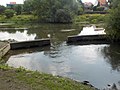
At the northern end of the lake, a campsite for nature lovers was created where the Dolphin swimming club used to be . The sailing club Braunschweig e. In 1982 V. inaugurated a water sports center in the immediate vicinity on the west bank. The lake is regularly used by sailing boats, and regattas are also held. A DLRG guard station has been on the east side since 1973 . Swimming in the lake is prohibited.
In winter the South Pacific is a popular ice skating area. All year round, it is an attractive destination for walkers and joggers because of its size, the connection to Melverode and the adjacent parking spaces. Sports clubs use the path around the South Pacific as a running route.
The lake shores are partly leased by Braunschweig fishing clubs and are heavily frequented. In the late summer of 2019, so-called fish vices were installed in the lake by the project management organization ASV Braunschweig and other financial supporters (including the city of Braunschweig) in order to encourage the growth of young fish. An information board shows the background, according to which the lake is normally connected to the Oker and only when the tide is low the Oker is closed by dam beams.
Exhibition "South Sea Islands" June 2019
In June 2019, students from the Institute for Architectural Art at the TU Braunschweig installed several South Sea islands on the lake that were clearly related to climate change and its consequences. Under the title “Dystopia”, a palm-like South Sea island was made out of plastic waste and a water reservoir was made out of crates of drinks. A floating residential unit was able to save people even when the sea level rose, while a non-floatable raft was shown under the title “Habitat”.
Picture gallery

Map of the South Sea area with the historical Oker course
Overflow threshold to the Oker at the level of Melverode, looking east towards the village, July 2017

Earlier end of the Fuhse Canal on the South Pacific, looking east, April 2010

"Living Unit" as one of the South Sea islands , exhibition project 2019
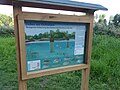
Information board on the Braunschweig South Sea for the erection of fish veins (2019)
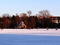
Winter fun on the South Sea with DLRG house, February 2012

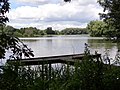
Wooden footbridge at the southern end of the lake, June 2017
Fishing jetty on the South Sea (east bank), May 2015

Sailing party in October 2014
Eastern end of the Fuhse Canal in the South Sea region, in front of the Oker.

Panoramic picture of the South Sea from the south-east in March 2020


literature
- Camerer, Garzmann, Schuegraf, Pingel (eds.): Braunschweiger Stadtlexikon , Joh. Heinr. Meyer Verlag, Braunschweig 1992, ISBN 3-926701-14-5 .
See also
Web links
- Information on the website of the city of Braunschweig
- History of the Braunschweig Sailing Club
- Internet presence of the Braunschweig branch of the DLRG
- Map of the fishing areas of the ASV Braunschweig
Individual evidence
- ↑ State Office for Geoinformation and Land Surveying Lower Saxony: Top 50 - Topographic Map 1: 50,000 Lower Saxony / Bremen , as of 2000.
- ↑ a b c d The South Seas (website of the city of Braunschweig). Retrieved April 7, 2015 .
- ↑ Depth map in high resolution. (JPG) ASV Braunschweig from 1922 e. V., accessed on September 15, 2019 .
- ↑ The display board explains the South Seas project. ASV Braunschweig from 1922 e. V., accessed on February 19, 2020 .
- ↑ South Sea Islands. (PDF) TUBS, accessed on June 23, 2019 .
.JPG)
Arboretum | Medicinal Plant Garden | Botanical garden | Bürgerpark | Franz's field | Gaussberg | Green area at the Westbahnhof | Heidbergsee and Park | Hermann-Löns-Park | Inselwallpark | Kennel | Kiryat Tivon Park | Monastery garden | Monastery park | Lion Wall | Museum park | North Park | Riddagshausen nature reserve | Oil Persee | Prinz-Albrecht-Park and Nussberg | Ring track | Richmond Park | School and community garden | City Park | South Seas area | Südstadtpark | Theater park | Vieweg's garden | West Park
Planned: Park on Münchenstrasse | Formerly: Castle Park