Eisenbüttel
|
|
|
|---|---|
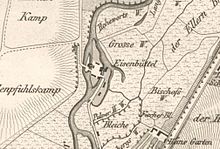
| The location of Eisenbüttel on a historical map around 1714–1750 |
Eisenbüttel was a village that was dissolved in the core city of Braunschweig in the 19th century .
Eisenbüttel was located directly on the Oker south of Braunschweig and was proven as a mill location as early as the 12th century. Today it is located in the city districts of Viewegsgarten-Bebelhof and the western ring area . Due to the street name "Eisenbütteler Straße", the place name is still known today.
First mention
An Eysenbutle is mentioned as a mill as early as 1180. Based on the syllables “ -büttel ” here and other “Büttel” occurring in Brunswick, Hahne suspects “ residents expelled from the areas on the lower Elbe by the invasions of the Northmen” who “since 9/10. Century were settled here by the landlords in order to clear a small piece of the still untouched alluvial forests on the rivers and to set up mills ”. Hahne suspects personal names in the syllables in front of the names. Hahne estimates the farmland in Eisenbüttel to be 30 to 60 acres.
Use of hydropower
The mill
The mill belonged to the monastery of St. Cyriakus , which Margrave Ekbert II had founded. The mill is said to go back to him, but it is only mentioned around 1200. Legend has it that Ekbert II was murdered in the mill by the riders of Emperor Henry IV . Most historians name a mill near Selke in the Harz Mountains as the place where Ekbert II was slain on July 3, 1090. On the other hand, the Brunswick lawyer and historian Julius Dedekind suspected that the margrave was most likely not murdered either in the mill in Eisenbüttel or in the Selketal, but near Isenbüttel an der Salke, in today's Gifhorn district . Ekbert II was buried in the Cyriakus pen.
The mill stayed with Cyriaki until 1580, but was given to citizens in return for ground rent. In 1580 the city bought the mill for 6,500 thalers. From the certificate it becomes clear “that at that time it was a whole mill system [...] 2 grinding mills, 1 large grinding mill with 5 mills, 1 fulling mill (for compacting and tamping woven cloths) with 2 mills, two further grinding mills, 1 bark mill (Lohmühle) […] 1 powder mill located off the beaten track ”.
Eisenbüttel got into the clashes between the city of Braunschweig and its dukes, the place and the mills were destroyed and rebuilt several times.
Hydropower from the 19th century
Around 1805 there were four grinding mills here, a tan, fulling, bark and powder mill. In 1843, Gottlieb Luther, the founder of Luther-Werke , built a tinder mill , the exact location of which is not known. The city of Braunschweig bought the mill in 1882 and built a hydropower plant that was already in operation in 1911. It was used to generate electricity for the nearby former pumping stations of the Bürgerpark waterworks and the then newly built Rüningen waterworks . The total output was 208 hp , i.e. around 150 kW. The power plant was badly damaged in World War II and shut down in 1962. Since then it has housed the water service of the city of Braunschweig and the city drainage system of Braunschweig.
In addition to the weir system, a fish pass was set up in 2005 as a fish canoe pass , which is also passable for canoeists.
The 40-ton weir roller installed in 1940/1941 was dismantled in 2012 and replaced by two fish- bellied flaps . The weir system was redesigned in this measure. The Eisenbütteler weir still has a central role in regulating the Oker water level in the Braunschweig city center.
Heinrichshafen excursion restaurant
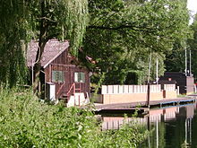
From 1707 a restaurant was built from a mansion. The name Heinrichshafen has been handed down for them since 1873 , which was derived from the first name of the tenant Gerecke. With this restaurant, which existed until the 1960s, Eisenbüttel developed into an excursion destination that was approached by motorboats from the old main station . The still existing arm of the river is used today by the neighboring clubs and the water service of the city of Braunschweig, and since 1996 it has also been the scene of an annual ice bet between prominent citizens of the city.
Development of the area from the middle of the 19th century
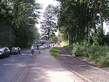
Eisenbüttel no longer exists as a place, but some of the oker arms that can be identified on early maps are still there today. The road to Eisenbüttel, which branched off from Wolfenbütteler Strasse in 1671 at the latest, was called "Eisenbüttel" from 1860 to 1882, and then until today "Eisenbütteler Strasse". The former place is closely connected to the rail traffic in Braunschweig. From 1838 the Duke Brunswick State Railway ran west of Eisenbüttel from Brunswick to Wolfenbüttel . In 1870 the road and rail company was administered here . A turning loop of the tram existed until 2008, but since the 1960s it has only been used during the trade fair at the nearby exhibition center and has now been dismantled.
The Helmstedt Railway, which went into operation in 1872, ran south of Eisenbüttel. The Braunschweig route must have existed before, however, as the St. Leonhard to Löffelsend marshalling yard on this route was already in operation in 1871. In the immediate vicinity of Eisenbüttel, a possible location for the through station, which was already imagined at that time, was discussed from the end of the 19th century, but it was opened further east at today's Berliner Platz in 1960 (see Braunschweig Hauptbahnhof ).
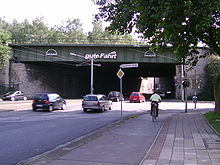
The dams that belong to the railway bridge built in 1937 over Wolfenbütteler Strasse also characterize the area around the former mill town today, as does the adjacent public park , the exhibition grounds (since 1973) and the nearby Kennel swimming pool.
Today, near the Eisenbüttel weir, the Braunschweig volunteer fire brigade (city center fire brigade), several Braunschweig authorities (civil and disaster control, water service), sports facilities (sports hall, Jahnplatz district sports facility) and various club houses (deaf sports club, marine home, model ship club) are located. Opposite the exhibition center are houses with gardens on the Oker on Eisenbütteler Straße.
Literary adaptation
In her story " Der Müller von Eisenbüttel ", the writer Benedektiven Naubert (1752–1819) describes the story of a miller in whose mill Margrave Egbert died.
See also
literature
- Wilhelm Appelt, Theodor Müller: Water arts and waterworks of the city of Braunschweig. Braunschweig 1965.
- Otto Hahne: Old individual farms in the city of Braunschweig. Braunschweig 1954.
- Karl-Heinz Löffelsend: The Helmstedt: the story of a street and its inhabitants. Braunschweig 2005, 2006.
- Pingel, Norman-Mathias: City expansion and municipal authorities in Braunschweig 1851-1914. Hanover 1998.
Web links
Individual evidence
- ↑ a b Otto Hahne: Old individual farms in the urban area of Braunschweig. Braunschweig 1954.
- ↑ Ludwig Ferdinand Spehr: Dedekind, Julius . In: Allgemeine Deutsche Biographie (ADB). Volume 5, Duncker & Humblot, Leipzig 1877, p. 15 f.
- ^ A b Wilhelm Appelt, Theodor Müller: Water arts and waterworks of the city of Braunschweig. Braunschweig 1965.
- ↑ a b c Dieter Heitefuß: Braunschweiger Zeitung. 17th October 2012.
- ^ A b c d Norman-Mathias Pingel: City expansion and municipal authorities in Braunschweig 1851-1914. Hanover 1998, p. 167.
- ↑ Hartmut Nickel: In: Braunschweiger Stadtlexikon. Joh. Heinr. Meyer Verlag, Braunschweig 1992.
- ↑ Water board Mittlere Oker: Replacement of the existing roller weir with a new building. Braunschweig 2009, document ( page no longer available , search in web archives: braunschweig.de ) (PDF) accessed on November 6, 2011.
- ↑ Ice bet on the Scherbelberg. In: Braunschweiger Zeitung. January 2013 ( braunschweiger-zeitung.de ).
- ↑ The history of the city of Braunschweig in maps, plans and views. With contributions from Jürgen Mertens and Richard Moderhack. F. 23.
- ^ Karl-Heinz Löffelsend: The Helmsteder. Braunschweig 2006; P. 54 ff.
- ↑ The Rinlake'sche station map for the city of Braunschweig, judged by the architectural and engineering association for the Duchy of Braunschweig. Brunswick 1899.
- ↑ Braunschweig main station. 1960, Braunschweig 1860, p. 19 ff.
- ^ Benedikt Naubert: New folk tales of the Germans. Volume 3. Weygand, Leipzig 1792, pp. 323-398 ( Commons ).
Coordinates: 52 ° 15 ' N , 10 ° 31' E


