
Madamenweg
| Madamenweg | |
|---|---|
|
|
|
.JPG) |
|
| Lower section of Madamenweg, view out of town in west direction. | |
| Basic data | |
| place | Braunschweig |
| District | Western ring area |
| Hist. Names | Steinweg, stately way |
| Connecting roads | Am Hohen Tore, Rösturm, Hannoversche Strasse ( B 1 ) |
| Cross streets | Wilhelmitorufer, Broitzemer Strasse, Goslarsche Strasse, Altstadtring, Melanchtonstrasse, Gabelsbergerstrasse, Pfingststrasse, Kleine Kreuzstrasse, Weinbergstrasse, Schüßlerstrasse, Dorntriftweg, An der Horst, Im Ganderhals, Strombeckstrasse, Reuchlinstrasse |
| Buildings | Raffurm , Madamenweg bunker, Madamenweg 6a ( Gustav Knuth's house ), Okerbrücke Am Hohen Tore |
| use | |
| User groups | Pedestrian traffic , bicycle traffic , car traffic , public transport |
| Technical specifications | |
| Street length | 4 km |

The Madamenweg is a four kilometer long street in the western ring area of the city of Braunschweig . It received its current name in the late 17th century. The renaming was initially carried out by the local population, who jokingly expressed that the then Brunswick Duke Rudolf August 1681, at the age of 54 years in his second marriage, the just 18-year-old raisin Elisabeth Menthe , former maid of his deceased first wife Christiane Elisabeth von Barby , married. “Madame Rudolfine”, as she was called, often took this route to drive to the castle, which she had received as a present from her Guelph husband as a summer residence. Or she returned from there to the Brunswick residence, the Gray Court . That is why the street was soon popularly called "Damenweg" or "Madamenweg". The name "Madamenweg" was not officially added to the Braunschweig address book until 1860 .
history
Originally it was a connection between the High Gate and the old military and trade route, which since the Middle Ages connected Magdeburg , 85 km east of Braunschweig, with Hildesheim 45 km to the west . The name “Madamenweg” did not appear until 1695. Up to this point in time it was a paved “manorial path” that ran between Vechelde Castle near Klein Gleidingen and the Hohe Tor in Braunschweig. Out of town, directly after the Okerbrücke Am Hohen Tor, the street was called “Steinweg”, as the stones for the first churches and stone buildings in the town were transported from the quarry on the Lindenberg near Steterburg .
Buildings
After 1860 the Madamenweg was chaused . One of the first buildings to be erected was the half-timbered house Madamenweg 163, which housed a craft business . Until around 1870, however, the street was largely without further development. Only in the following years did other craftsmen settle in. The Braunschweig-born actor Gustav Knuth lived in the house Madamenweg 6a (previously 4) until he was 17 . The connection between Madamenweg and Gebhard-von-Bortfelde-Weg was renamed Gustav-Knuth-Weg. After 1889, on the basis of the local development plan by the town planning officer Ludwig Winter, the area outside the city in front of the Hohe Tor was redesigned by building a police station that is still in existence today as the first brick building.
Due to the destruction caused by the bombing during the Second World War , today's buildings are not uniform. Half-timbered houses from the 19th century alternate with brick buildings from the 20th and new buildings from the post-war period. The most striking and largest building today is an air raid shelter built in 1941/42 for 1,500 people on the Madamenweg 130 property. It is the largest bunker built in Braunschweig . The building is 48.90 m long and 21.40 m wide; it was the original height of 13.00 m until the renovation in 2012/13. After the end of the war and until its closure in 1974, the bunker served as an emergency and transitional shelter for bombed-out people, the homeless and refugees. In autumn 2013 the conversion to a residential building was completed.
Impressions
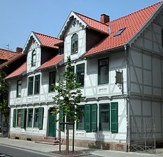
Madamenweg 163, one of the oldest buildings on the street. Built in 1867.

Madamenweg 6a (formerly 4), Gustav Knuth lived here until he was 17.
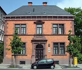
Police station of the Braunschweig Police Department , built around 1890

The largest bunker built in Braunschweig is on Madamenweg.
.JPG)
.JPG)
.JPG)
.JPG)


literature
- Wilhelm Bornstedt : The army and trade routes from Braunschweig over the Vechelder Damm to Hildesheim and their rival roads around 1400. In: Braunschweigisches Jahrbuch. Volume 52, 1971. Self-published by the Braunschweigischer Geschichtsverein , Braunschweig 1970, pp. 211-216.
- Luitgard Camerer , Manfred Garzmann , Wolf-Dieter Schuegraf (eds.): Braunschweiger Stadtlexikon . Joh. Heinr. Meyer Verlag, Braunschweig 1992, ISBN 3-926701-14-5 .
- Jürgen Hodemacher : Braunschweig's streets - their names and their stories. Volume 2: Okergraben and city ring. Elm-Verlag, Cremlingen 1996, ISBN 3-927060-12-7 .
- Wolfgang Kimpflinger: Monument topography Federal Republic of Germany . Architectural monuments in Lower Saxony. Volume 1.2 .: City of Braunschweig. Part 2, Hameln 1996, ISBN 3-8271-8256-5 .
Web links
- When the tram was still ringing on Madamenweg. on braunschweiger-zeitung.de
Individual evidence
- ^ Wilhelm Bornstedt: The military and trade routes from Braunschweig over the Vechelder Damm to Hildesheim and their rival roads around 1400. P. 212. ( online PDF ( Memento from December 19, 2014 in the Internet Archive ))
- ↑ Camerer, Garzmann, Schuegraf, Pingel: Braunschweiger Stadtlexikon. P. 150.
- ^ Wilhelm Bornstedt: The army and trade routes from Braunschweig over the Vechelder Damm to Hildesheim and their rival routes around 1400. P. 211.
- ↑ Jürgen Hodemacher: Braunschweigs streets - their names and their stories. Volume 2: Okergraben and city ring. P. 204f.
- ↑ a b Wolfgang Kimpflinger: Monument topography Federal Republic of Germany. Architectural monuments in Lower Saxony. Volume 1.2 .: City of Braunschweig. Part 2, p. 164.
- ↑ Unforgettable in the hometown. Memory of the Braunschweig folk actor at his home on Madamenweg . Braunschweiger Zeitung of November 13, 2008.
- ↑ Wolfgang Ernst: ÜberLebensorte - Bunker in Braunschweig from planning to the present. in: Braunschweig workpieces. Volume 108. Appelhans Verlag, Braunschweig 2006, ISBN 3-937664-42-4 , p. 107f.
- ↑ Wolfgang Ernst: ÜberLebensorte - Bunker in Braunschweig from planning to the present. P. 115.
Coordinates: 52 ° 15 ′ 34 " N , 10 ° 28 ′ 54.2" E