
Great Gleidingen
|
Great Gleidingen
Vechelde municipality
|
||
|---|---|---|
 |
||
| Height : | 80 m above sea level NHN | |
| Area : | 2.45 km² | |
| Residents : | 749 (December 31, 2018) | |
| Population density : | 306 inhabitants / km² | |
| Incorporation : | March 1, 1974 | |
| Postal code : | 38159 | |
| Area code : | 05300 | |
Location of Groß Gleidingen in Lower Saxony |
||
 Location of Groß Gleidingen in the municipality of Vechelde
|
||

Groß Gleidingen is a district of the municipality of Vechelde in the Peine district in Lower Saxony .
geography
Geographical location
Groß Gleidingen is located in the lowlands of the Braunschweig-Hildesheimer Lößbörde in the transition area between the foothills of the northern Harz foreland and the northern German lowlands . Groß Gleidingen is bounded in the west by the Salzgitter branch canal and in the south by the Hanover – Braunschweig and Hildesheim – Braunschweig railway lines .
Neighboring places
| Denstorf | Klein Gleidingen | |
| Sonnenberg |
.svg)
|
Timmerlah (Braunschweig) |
| Üfingen (Salzgitter) | Stiddien (Braunschweig) |
history
History of the district
Groß Gleidingen is mentioned in a document as early as the 9th century as "Sudergletinge", later also as "Gledinge" (1195), "Snitgledinge" (1260) and "Groten Gleon" (1570).
Groß Gleidingen is first mentioned by name in an inventory of the Fulda monastery from the 9th century. It mentions the donation of a certain Odiltag and his wife Wentelsuvint to the Fulda monastery around the year 780. There 20 goods of the Liergau are mentioned, including Sudergletinge , probably Groß Gleidingen.
Around 1440, Groß Gleidingen was combined with another ten villages in the Principality of Braunschweig-Wolfenbüttel to form the administrative and judicial district " Amt Eich " or "Zur Eiche". The office covered the area west of the city of Braunschweig , from the Braunschweiger Landwehr to about the river Aue . In 1501, Duke Heinrich I , called the Elder , pledged the villages of the office to the city of Braunschweig, under whose administration they remained until 1671, when the era of the independent city of Braunschweig was ended by the reconquest of the princes of Braunschweig-Wolfenbüttel.
|
|
|---|---|
| The first cartographic representation of Groß Gleidingen in a visual map in the official atlas of the Principality of Braunschweig-Wolfenbüttel by Gottfried Mascop , 1574 |


In 1802 Groß Gleidingen had 154 inhabitants in 24 campfire sites. With the Principality of Braunschweig-Wolfenbüttel, Groß Gleidingen was incorporated into the Kingdom of Westphalia created by Napoleon in 1807 . After its dissolution in 1813, the place belonged to the Duchy of Braunschweig until 1918 .
According to the full topographic-justitia step manual of Sämtliche German states of Johann Friedrich Kratzsch counted United Gleidingen 1843 a total of 24 houses with 143 inhabitants:
- Large = Gleidingen. - Df., With filk. [= Branch church] of Denstorf an der Aue. - 24 H. 143 E. - Heart. Braunschweig. - Vechelde Justice Office. - Kreisger. Braunschweig. - Higher Regional Court Wolfenbüttel.
With the completion of the Hanover – Braunschweig railway in 1843, Groß Gleidingen became a stop on the railway line and received a train station. In 1888 the approximately 35 km long connection between the Hildesheim – Braunschweig line and the Hanover – Braunschweig line near Groß Gleidingen was put into operation. In the early 1980s, the station was rededicated to a purely operating station.
Groß Gleidden's assignment to the district of Braunschweig and its status as an independent municipality ended on March 1, 1974 in the course of the regional reform of Lower Saxony .
Village image and district development
Groß Gleidingen developed from a small square village with the church on the east side into a clustered village . The old village is mainly determined by Central German farms. In the past few decades, the place expanded to the north and east with homes and housing estates.
In the past few decades, numerous lakes were created in the vicinity of the place through sand and gravel mining , which were recultivated after the construction material extraction was finished. A gravel mine is currently in operation in the north-west of the village.
The Protestant Groß Gleidinger Church is located in the center of the village. According to the hereditary registry, it was already mentioned in 1587, but must have been fundamentally changed after a fire in 1780. The small village church offers space for around 130 people. It was renovated in 1996 with own funds and is a meeting room for the community. However, many events and meetings also take place in the nearby village community center, the old school.

Gross Gleidingen Church
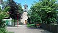
Gross Gleidingen Church
Square opposite the church

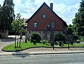
Entrance from the direction of Braunschweig-Timmerlah


politics
Local council
The local council of Groß Gleidingen has been composed of three councilors and five councilors from the following parties since 2016:
| year | SPD | CDU | Non-party | total | was standing |
| 2016 | 5 | 2 | 1 | 8 seats | Local election on September 11, 2016 |
| 2011 | 5 | 2 | 0 | 7 seats | Local election on September 11, 2011 |
| 2006 | 5 | 2 | 0 | 7 seats | Local election on September 10, 2006 |
Local mayor
The local mayor is Bärbel Kuschnik (SPD). In 2005, she replaced her predecessor Manfred Ehlers (SPD).
coat of arms
The coat of arms shows a shield divided into three parts by a silver drawbar . The upper field is blue, in the left you can see a blue flax blossom on a gold background and on the right a silver horn on a red background. The drawbar symbolizes the local fork in the railway line from Braunschweig in the direction of Hanover and Hildesheim. The blue blossom is reminiscent of the extensive flax cultivation that was practiced here in the 17th and 18th centuries. The silver horn comes from the coat of arms of the Brunswick patrician family "von Horneburg", who owned here episcopal Hildesheim fiefs. The horn also symbolizes the herdsmen of the place. The blue field shows through the combination with gold the affiliation to the state and the district of Braunschweig . The combination of red and gold reflects the colors of Hildesheim Abbey . It was approved on January 10, 1972 by the Braunschweig administrative president. The design comes from Wilhelm Krieg.
literature
- Heinrich Heike-Cramm: Look into the past of a village. Serious and cheerful things from Groß Gleidingen. Self-published. Vechelde / Groß Gleidingen 1984.
Web links
Individual evidence
- ↑ Population figures . In: Website of the municipality of Vechelde. December 31, 2018, accessed March 11, 2019 .
- ^ Richard Andree : Braunschweiger Volkskunde. Friedrich Vieweg and Son Verlag, 2nd edition, Braunschweig 1901.
- ^ Historical Association for Lower Saxony (ed.): Hannoversche Geschichtsblätter. Volume 5, 1902, p. 262.
- ↑ August von Wersebe : Description of the district between the Elbe, Saale and Unstrut, Weser and Werra . Hahnsche Hofbuchhandlung, Hanover 1829, p. 193 .
- ^ Georg Hassel : Geographical-statistical description of the principalities of Wolfenbüttel and Blankenburg . Friedrich Bernhard Culemann, Braunschweig 1802 ( digitized ).
- ^ Matthias Blazek : The Electorate of Hanover and the years of foreign rule 1803-1813. Ibidem Verlag, Stuttgart 2007, pp. 27 ff, ISBN 978-3-89821-777-4 .
- ^ Johann Friedrich Kratzsch : Complete topographical-judicial manual of the entire German federal states. First department, Eduard Zimmermann Verlag, Naumburg 1843, p. 246.
- ↑ H. Schwabe: Draft of a railway plan for the Kingdom of Prussia, with special consideration of the railways of subordinate importance. Berlin Lith. Institute, Berlin 1878.
- ^ Matthias Blazek: From the Landdrostey to the district government - The history of the district government of Hanover as reflected in the administrative reforms. Stuttgart 2004, ISBN 3-89821-357-9 .
- ↑ Uwe Pape : The organs of the Braunschweig district. Self-published, 1968, p. 36.
- ↑ a b The local council of Groß Gleidingen 2016. In: Ratsinformationssystem der Gemeinde Vechelde. Retrieved June 5, 2018 .
- ^ The local council of Groß Gleidingen 2011. In: Ratsinformationssystem der Gemeinde Vechelde. July 31, 2017, archived from the original on October 14, 2012 ; accessed on June 5, 2018 .
- ↑ Harald Meyer: Proof of confidence in Kuschnik. In: Internet site of the Braunschweiger Zeitung. October 4, 2005, accessed June 5, 2018 .
- ^ Arnold Rabbow: New Braunschweigisches Wappenbuch . Braunschweiger Zeitungsverlag, Meyer Verlag, Braunschweig 2003, ISBN 3-926701-59-5 , pp. 150–151.

Alvesse | Bettmar | Bodenstedt | Denstorf | Fürstenau | Groß Gleidingen | Klein Gleidingen | Kochingen | Liedingen | Sierße | Sonnenberg | Vallstedt | Vechelade | Vechelde | Choose | Wedtlenstedt | Wierthe