Sir
|
Sir
Vechelde municipality
|
||
|---|---|---|
| Coordinates: 52 ° 16 ′ 19 ″ N , 10 ° 20 ′ 0 ″ E | ||
| Height : | approx. 78 m above sea level NHN | |
| Area : | 6.47 km² | |
| Residents : | 836 (December 31, 2018) | |
| Population density : | 129 inhabitants / km² | |
| Incorporation : | March 1, 1974 | |
| Postal code : | 38159 | |
| Area code : | 05302 | |
|
Location of Sierße in Lower Saxony |
||
|
Location of Sierße in the municipality of Vechelde
|
||
Sierße is a district of the municipality of Vechelde in the Peine district in Lower Saxony .
geography
location
Sierße is located on the B 65 between Vechelde and Peine and on the Hanover – Braunschweig railway line .
Neighboring places
| Woltorf (Peine) | Fürstenau | |
| Schmedenstedt (Peine) |

|
Choose |
| Münstedt (Ilsede) | Bettmar | Vechelde |
history
Sierße was mentioned in a document in 1182 as "Sigerdessem" and has belonged to the Bettmar district court since 1152 . In the Middle Ages, there also seems to have been a court in the district of Sierße, in the forest "Sierßer Holz".
In 1802, Sierße had 409 inhabitants in 56 fireplaces. With the Principality of Braunschweig-Wolfenbüttel , Sierße was incorporated into the Kingdom of Westphalia created by Napoleon in 1807 . After its dissolution in 1813, the place belonged to the Duchy of Braunschweig until 1918 .
Siere's assignment to the Braunschweig district and its status as an independent municipality ended on March 1, 1974 in the course of the regional reform of Lower Saxony with the incorporation into Vechelde.
politics
Local council
The local council of Sierße consists of seven councilors from the following parties:
| Local election | SPD | CDU | total |
|---|---|---|---|
| 11th September 2016 | 5 | 2 | 7 seats |
| September 11, 2011 | 5 | 2 | 7 seats |
| September 10, 2006 | 5 | 2 | 7 seats |
Local mayor
The local mayor is Martin Timpe (SPD).
coat of arms
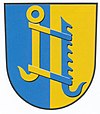
The design of the municipal coat of arms comes from the heraldist Arnold Rabbow. The coat of arms was adopted by the local council on November 17, 1981.
| Blazon : "In the shield split by blue and gold , a kettle hook in mixed up colors." | |
| Justification of the coat of arms: The split shield indicates the border location of the place between the Duchy of Braunschweig-Lüneburg and the areas of the Hildesheim monastery . The affiliation to the respective rulership changed several times in the 12th to 15th centuries. The kettle hook comes from the coat of arms of the von Gustede family , who had three black kettle hooks. They were mentioned as the first administrators of the ducal-Brunswick office of Sierße before 1320. The blue-gold color confirms the affiliation to the former state of Braunschweig. |
Culture and sights
Buildings
- The church in Sierße was last rebuilt in 1783.
- The chapel of the cemetery in front of Sierße is worth seeing
Photo gallery
Economy and Infrastructure
Sierße was an agricultural village until the second half of the 20th century. The village image mostly shows small courtyards with central German and Lower Saxon house and courtyard shapes, with the central German construction predominating. Today, however, agriculture is only of minor importance in the structure of employment. Many of the village's residents pursue their purchases mainly in the regional center of Braunschweig or in the nearby industrial areas in the Salzgitter - Peine area .
In the past few decades, small complexes of modern homes and two-story row houses have emerged in the east and north. In 1997, the new building area "Mühlenblick" was developed on federal road 65 in the direction of Bettmar.
Web links
Individual evidence
- ↑ Population figures . In: Website of the municipality of Vechelde. December 31, 2018, accessed March 11, 2019 .
- ^ Johannes Heinrich Gebauer : History of the city of Hildesheim . tape 1 . August Lax Verlag, Hildesheim 1922.
- ^ Georg Hassel : Geographical-statistical description of the principalities of Wolfenbüttel and Blankenburg . Friedrich Bernhard Culemann Verlag, Braunschweig 1802 ( digitized in the Google book search).
- ^ Federal Statistical Office (ed.): Historical municipality directory for the Federal Republic of Germany. Name, border and key number changes in municipalities, counties and administrative districts from May 27, 1970 to December 31, 1982 . W. Kohlhammer, Stuttgart / Mainz 1983, ISBN 3-17-003263-1 , p. 268 .
- ↑ a b The local council of Sierße. In: vechelde.rat-online.eu. Retrieved December 22, 2016 .
- ^ A b Arnold Rabbow: New Braunschweigisches Wappenbuch. The coats of arms and flags of the communities and districts in the city and districts of Braunschweig, Gifhorn, Goslar, Helmstedt, Peine, Salzgitter, Wolfenbüttel, Wolfsburg. Braunschweiger Zeitungsverlag, Meyer Verlag, Braunschweig 2003, ISBN 3-926701-59-5 , p. 152-153 .
- ^ Coat of arms of Sierße. In: ngw.nl. Retrieved November 24, 2019 .


