District of Duderstadt
| coat of arms | Germany map | |
|---|---|---|

|
Coordinates: 51 ° 31 ' N , 10 ° 15' E |
|
| Basic data (as of 1972) | ||
| Existing period: | 1885-1972 | |
| State : | Lower Saxony | |
| Administrative region : | Hildesheim | |
| Administrative headquarters : | Duderstadt | |
| Area : | 224.46 km 2 | |
| Residents: | 41,200 (Dec 31, 1971) | |
| Population density : | 184 inhabitants per km 2 | |
| License plate : | DUD | |
| Circle key : | 03 2 32 | |
| Circle structure: | 30 parishes | |
| Location of the district of Duderstadt in Lower Saxony | ||
The district of Duderstadt was a district with Duderstadt as the district town, which became part of the districts of Göttingen and Northeim on January 1, 1973 .
geography
location
The 220 km² large district was located in southern Lower Saxony and comprised most of the sub-area .
Neighboring areas
In 1972 the district bordered in a clockwise direction in the northwest with the districts Northeim and Osterode (both in Lower Saxony), the district Worbis (in the GDR ) and the district Göttingen (again in Lower Saxony).
history
The Duderstadt district was formed on April 1, 1885 from the Gieboldehausen office and the city of Duderstadt, which had belonged to Prussia since 1867 and had previously been Hanoverian . The district became part of the Hildesheim administrative district . Since 1939 the district was called Landkreis Duderstadt . It comprised 28 communities, had a total area of 224 km² and in 1972 had 44,184 inhabitants. As district administrators functioned until 1945 Prussian state officials, the tasks such as the supervision perceived on local administration. The local self-government took over the district committee . The district administrator and district committee were independent authorities until 1946. A part of the local court served as the administrative seat until 1914 , after which the new building at Worbiser Straße 9 was used for the same purposes. In 1946, based on the English model, a new district constitution was adopted, with a dual leadership, with the upper district director as electoral officer and the district administrator as representative of the district council .
As part of the municipal territorial reform in Lower Saxony , the Duderstadt district was merged with the Göttingen and Münden districts to form the newly formed Göttingen district , with the exception of the village of Lindau , which was incorporated into the Northeim district .
Population development
|
|
politics
District administrators
District administrators / senior district directors as heads of the district administration
- 1885–1900 Karl von Oven
- 1900–1917 Christian Karl von Byla
- 1917–1927 Hans von Oldershausen
- 1927–1933 Reinhold Schuster
- 1933–1944 Max Heinemann
- 1944–1945 Hermann Kratzin
- 1945–1946 Carl Goldmann
- 1946–1947 Wilhelm Schell, senior district director
- 1948–1967 Matthias Gleitze , senior district director
- 1968–1972 Walter Thöne, senior district director
District councilors after 1946 as chairmen of the district council
- 1946 Carl Goldmann
- 1946–1963 Karl Diedrich
- 1963–1972 Willi Döring
coat of arms
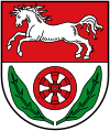
| Blazon : “Divided by red and silver (white); above a jumping silver (white) horse, below a six-spoke red wheel , each accompanied by a green tobacco leaf. " | |
| Justification of the coat of arms: The coat of arms designed by the heraldist Otto Rössler von Wildenhain and approved by the Lower Saxony Ministry of the Interior on May 27, 1950 shows the Lower Saxony horse and the Kurmainzer wheel. Both symbols represent previous affiliations. The tobacco leaves are reminiscent of tobacco growing in the district in the 19th century. |
Communities
The municipalities of the Duderstadt district were (residents on June 6, 1961):
|
|
|
Westerode was incorporated into the city of Duderstadt on February 1, 1971.
License Plate
On July 1, 1956, the district was assigned the distinctive sign DUD when the vehicle registration number that is still valid today was introduced . It was issued until March 7, 1973. Due to the license plate liberalization , it has been available in the Göttingen district since November 15, 2012. The district town, which has its own registration office, is excluded.
literature
- Dieter Wagner: Description of the agricultural. and economic Conditions in the rural district of Duderstadt 1972. In: Eichsfelder Heimatzeitschrift. 55 vol. (2011), issue 7/8, page 266
Web links
Individual evidence
- ^ District regulation for the province of Hanover (1885)
- ^ Federal Statistical Office (ed.): Historical municipality directory for the Federal Republic of Germany. Name, border and key number changes in municipalities, counties and administrative districts from May 27, 1970 to December 31, 1982 . W. Kohlhammer, Stuttgart / Mainz 1983, ISBN 3-17-003263-1 , p. 206 .
- ↑ Statistical Yearbook for the Federal Republic of Germany 1973
- ↑ armorial district Duderstadt, 1960, p 17 + 23
- ↑ Lower Saxony State Administration Office (ed.): Municipal statistics of Lower Saxony 1960/61. Part 1: Population and Employment, Hanover 1964, p. 92.


