Nettles
|
Nettles
City of Duderstadt
|
||
|---|---|---|
| Coordinates: 51 ° 29 ′ 41 ″ N , 10 ° 11 ′ 1 ″ E | ||
| Height : | 190 m above sea level NN | |
| Area : | 13.21 km² | |
| Residents : | 2053 (Nov. 1, 2019) | |
| Population density : | 155 inhabitants / km² | |
| Incorporation : | 1st January 1973 | |
| Postal code : | 37115 | |
| Area code : | 05527 | |
|
Location of Nesselröden in Lower Saxony |
||
|
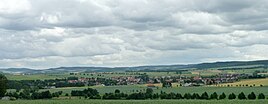
Nettle from the northwest
|
||
Nesselröden is a district of the city of Duderstadt in the district of Göttingen in southern Lower Saxony .
geography
The village is located on state road 569 between Etzenborn and Westerode , a good five kilometers southwest of Duderstadt and 16 kilometers east of Göttingen in the Untereichsfeld . The district is located in the Nathetal on the southern edge of the Golden Mark surrounded by wooded hills, such as the Fuchsberg (approx. 285 m) in the northwest, the Hainholz (293.7 m) in the west and the Nesselröder Forest (283.8 m) in the south. The former inner German border and today's Lower Saxony- Thuringia border ran immediately to the south .
history
The first written mention of the place is in a document in the Mainz document book from the years 1189–1190 as Nescilrite . Other authors refer to Nesselröden near Herleshausen when it was sometimes mentioned as noscilrite from 1183 . In the further course of the written mentions, the place name is passed down very differently: 1221 Netelrede , 1236 Nitilrethe , 1297 Nezelridin , 1327 Neterede , 1421 Netelnroda . The name has appeared in its current form since the 19th century. Assumptions suggest that around 1227 a parish or a church could have existed in Nesselröden, since a cleric named Johannes de Netelrede is mentioned in documents . From the year 1334 the place, together with Duderstadt until the transition to Prussia in 1802, belonged to the possession of the Archbishopric Mainz . Nesselröden came to the territory of the city of Duderstadt as a council village at the end of the 14th century and remained in this dependency until 1866. Similar to the other council villages, Nesselröden was also obliged to provide manual and tensioning services . The upper mill, which burned down in 1928, is documented in 1314 and the lower mill, which was shut down in 1961, in 1327. The Nesselröder Warte was built in 1392 to the south-west of the village . It secured the area of influence of Kurmainz on the western border of the Kurmainzer Eichsfeld, at the "Duderstädter Knick". The control room, demolished before 1800, was constantly manned until 1564. Today only a 35 to 40 m wide, triple wall and ditch system reminds of the earlier fortifications. Between 1574 and 1607 the place was subject to Protestantism , then returned to Catholicism . During the Thirty Years' War , the place was badly damaged. The waiting room and 60 of a total of 80 hearths were destroyed, the church burned down except for the tower. Following the war, a school and a community poor house were built in 1670, which were maintained until 1863. In the 18th and 19th centuries the town suffered from famine, cholera epidemics and repeated floods from the Nathe. The so-called hail cross reminds of the great storm of 1718 and is still the goal of an annual procession today.
On January 1, 1973 Nesselröden was incorporated into the city of Duderstadt. Until the German reunification in 1989 , a small border inspection office of the customs was set up in Nesselröden to monitor the inner-German border , which was subordinate to the customs commissioner Duderstadt (in the area of responsibility of the main customs office in Braunschweig ).
religion
The predominantly Catholic village has a Catholic parish with the patronage of St. George (Day of St. George: April 23). The current church was built and consecrated in 1856. According to tradition, a procession to the so-called hail cross is held once a year on the basis of a promise after a hailstorm in the 18th century. On October 10th, 2010 Andreas Braun from Nesselröden was ordained a priest, on October 31st, 2010 he celebrated his primacy in the parish church of St. Georg . Since November 1, 2014, the parish of St. Georg has also included the churches of St. Mauritius in Desingerode , St. Georg in Esplingerode , St. Johannes Baptist in Immingerode and St. Urban in Werxhausen .
politics
Local council
The local council consists of 13 councilors.
(As of: local election on September 11, 2011 )
Local mayor
Local mayor is Bernd Frölich (CDU).
coat of arms
The municipal coat of arms is a so-called Hagelkreuz (double-beamed cross), as it was often erected in Eichsfeld during the Electorate of Mainz.
Culture and sights
Structure of the parish church of St. Georg
Early traditions testify to a church building that was built in the form of a small, thatched-roof church and destroyed by Duke Christian von Braunschweig during the Thirty Years' War in 1623. In 1710 a new baroque building took place, to whose tower the neo-Romanesque nave of today's St. George's Church was added in 1853 . The main portal is made of red sandstone , it was - in line with the style and material of the nave - facing the older, lightly plastered tower facade. The interior of the church presents itself as a flat-roofed room with a polygonal choir closure . The arched windows only have colored glazing in the choir area , which comes from the time the church was built around 1853. The two-story main altar dates from 1760, has two side passages that lead to the sacristy behind , and was made by the sculptor Johann Bernhard Kopp, who is also responsible for the Madonna in the linden fence in Duderstadt. The crucifix in the central axis of the altar, however, is of an older date and was realized in 1666 by Andreas Georg Kersten, an equally important representative of Duderstädter Baroque carving. The altar that belonged to this cross was sold to Böseckendorf . In the recent past two evangelists have been placed above the side passages . The oldest object in the church is a Rhenish Pietà from 1430, it was in earlier times in a now demolished cave . The new version of the statue, as well as the bronze ambo , the celebration altar erected in 1981 and the halo were made by a Hanoverian sculptor.
Dudenborn desert
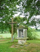
The Dudenborn desert is located southwest of the village . Today a wooden cross and a wayside shrine remind of the former settlement.
Sons of the place
- Leopold von Kaisenberg (1766–1835), landowner, lawyer and member of parliament
- Heinrich Engelhardt (1922–2003), politician (CDU)
literature
- Hans-Wilhelm Wiesemüller: Chronicle of Nesselröden . Volume 1: 1227-1977. Duderstadt 1977
- Egon Kreißl: Chronicle of Nesselröden . Volume 2. 1987
- Josef Engelke: Festschrift: Church consecration 150 years ago . 2006
Web links
Individual evidence
- ↑ Population statistics on the city of Duderstadt's website, accessed on May 7, 2020.
- ↑ a b c Kirstin Casemir, Uwe Ohainski, Jürgen Udolph: The place names of the district of Göttingen . In: Jürgen Udolph (Hrsg.): Lower Saxony Place Name Book (NOB) . Part IV. Publishing house for regional history, Bielefeld 2003, ISBN 3-89534-494-X , p. 289-293 .
- ↑ E. Kreißl: The story of Nesselröden. Retrieved June 21, 2010 .
- ^ F. Suck: An etymological place name lexicon for Kurhessen and Waldeck . Episode 1 ff., Kassel 1989 ff.
- ^ Federal Statistical Office (ed.): Historical municipality directory for the Federal Republic of Germany. Name, border and key number changes in municipalities, counties and administrative districts from May 27, 1970 to December 31, 1982 . W. Kohlhammer GmbH, Stuttgart and Mainz 1983, ISBN 3-17-003263-1 , p. 206 .
- ^ Source: Directory of the Federal Customs Administration 1975–1989
- ↑ http://wahlen.kds.de/2011kw/Daten/152007_000072/index.html


