Immingerode
|
Immingerode
City of Duderstadt
|
||
|---|---|---|
| Coordinates: 51 ° 29 ′ 14 ″ N , 10 ° 13 ′ 57 ″ E | ||
| Height : | 195 m above sea level NN | |
| Residents : | 508 (Nov. 1, 2019) | |
| Incorporation : | 1st January 1973 | |
| Postal code : | 37115 | |
| Area code : | 05527 | |
|
Location of Immingerode in Lower Saxony |
||
|
Aerial photograph (2013)
|
||
Immingerode is a place in the district of Göttingen in southern Lower Saxony . The village, which belongs to the Untereichsfeld , has been part of the city of Duderstadt since January 1, 1973 and has around 500 residents.
geography
Immingerode is three kilometers southwest of Duderstadt, close to the state border with Thuringia . The center is located at the confluence of the Großer Ike and Bruche zur Muse , a left tributary of the Hahle . The highest point in the area is the Pferdeberg (279 m).
In terms of traffic, Immingerode is connected via the district roads 112 and 120. Other neighboring towns are Nesselröden in the west, Tiftlingerode in the north, Gerblingerode in the east and the Thuringian towns of Teistungen in the southeast and Böseckendorf in the southwest.
history
Immingerode was first mentioned as Ymmingeroth in a document from Abbess Agnes II of Quedlinburg (1184–1203). The place was probably created in the 10th century as "clearing of the people of the real estate". Since the 15th century the place was one of the council villages of the city of Duderstadt. Immingerode is mentioned in an account book of the city of Duderstadt from 1432. In the following period, the place developed in such a way that the local knights, in contrast to the merchants, became increasingly impoverished and had to pledge their property to the city council. This set administrator, so-called Meier , to manage the noble estates. For the year 1670 five mine estates are mentioned in Immingerode.
In addition to the administration of the noble estates, the city council of Duderstadt in Immingerode exercised lower jurisdiction. As a result, the farmers had to do manual and clamping services, as well as had to pay taxes to the city. These taxes took the form of grain payments. It was not replaced until the 19th century. The tithe was abolished in 1852 , and manual and clamping services in 1861. In 1905 the salt oats were finally abolished.
Similar to other council villages at the time, Immingerode also suffered badly from the Thirty Years' War and the plague . This primarily concerned the number of inhabitants. While 1609 160 and 1620 even 180 people lived in the village, their number decreased to 75 at the end of the war. As the birth rate increased and many former residents returned, the population gradually recovered. At the beginning of the Second World War 379 people inhabited the place. The town experienced its peak in population figures in 1946, which happened when 233 refugees, displaced persons and evacuees were taken in. At that time there were 524 inhabitants. Due to emigration, the number fell to 460 people in 1960, which has remained relatively constant up to the present day.
politics
Local council
The local council consists of seven councilors and councilors.
- CDU : 5 seats
- Free voter community Immingerode: 2 seats
(As of: local election on September 11, 2011 )
Local mayor
Local mayor is Stefan Stollberg (CDU).
coat of arms
The coat of arms was approved on December 27, 1950.
It is based on a seal from Immingerode dated to 1266.
Culture and sights
Parish Church of St. John Baptist
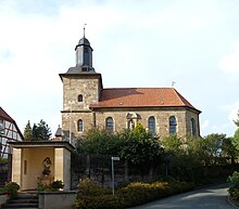
During the term of office of the archbishop's commissioner Herwig Böning (1666–1721) the construction of the Immingerode parish church of St. Johannes Baptist, which was built between 1718 and 1721, fell. On October 14, 1724, the church was consecrated by the auxiliary bishop Johann Joachim Hahn of the diocese of Mainz , who resided in Erfurt . Böning commissioned the two Duderstadt builders Markus and Christoph G. Frankenberg to build the church. Due to its massive size, the church tower takes up the entire width of the west facade, in the southern part of the church there is a portal that ends with a niche architecture of pilasters , fruit hangings and an arched segmented gable. On this gable there is a larger than life sandstone figure of the patron saint of the church, St. John . The nave has a single nave, extends over five bays and ends in a polygonal manner in the choir area. Belt arches divide the ribbed vault with keystones . It forms a contrast to the arched window openings. The three-storey altar in the choir dates from 1745. Figures of time and saints stand between the winding columns, the cranked entablature, segment gables, fruit bunches, putti , wreaths of rays and cartouches. They are kept in a dark red-green, marbling tone. An 81 cm high statue of Mary in gold mount with a crown and scepter for the child is also part of the church's inventory. In the church tower hangs a small sugar loaf bell (gospel bell ) from the 13th century, one of the oldest church bells in Eichsfeld . Since November 1st, 2014 the church belongs to the parish of St. Georg in Nesselröden .
Way of the Cross and Kluskapelle
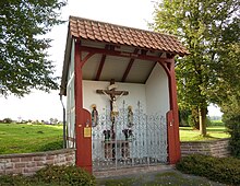
One of the most extensive crossroads in Lower Saxony is the one that leads from Immingerode to the Pferdeberg . It was built in 1884 and shows 14 sandstone housings with colored reliefs, on the pedestal of which a sandstone crucifix can be seen. Due to the fact that they are made of this very sensitive material, these landmarks are exposed to considerable weathering. In memory of the plague in 1682, a Kluskapelle was built at the end of the village in the direction of Böseckendorf . The current replica dates from the second half of the 19th century.
Memorial stone in memory of the mass exodus from the border area
To commemorate the escape of residents from Böseckendorf across the former inner-German border , two memorial stones were erected on the road to Böseckendorf in the early 1990s.
literature
- Hans Reuther : The wayside shrines of the lower field. With a directory of the wayside shrines that are important in terms of art and religious history. Mecke, Duderstadt 1961.
- Joachim Lehne: From the history of Immingerode . Mecke, Duderstadt 1934.
Individual evidence
- ↑ Population statistics on the city of Duderstadt's website, accessed on May 7, 2020.
- ^ Federal Statistical Office (ed.): Historical municipality directory for the Federal Republic of Germany. Name, border and key number changes in municipalities, counties and administrative districts from May 27, 1970 to December 31, 1982 . W. Kohlhammer GmbH, Stuttgart and Mainz 1983, ISBN 3-17-003263-1 , p. 206 .
- ↑ Map services of the Federal Agency for Nature Conservation ( information )
- ↑ http://wahlen.kds.de/2011kw/Daten/152007_000070/index.html
- ↑ Johannes Broermann: 615 Reichstaler, a barrel of beer. In: KirchenZeitung , issue 16/2017 of April 23, 2017, p. 12


