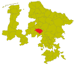
Nienburg district
| Basic data | |
|---|---|
| Prussian Province | Hanover |
| Administrative district | Hanover |
| Administrative headquarters | Nienburg / Weser |
| surface | 497.42 km² (1925) |
| Residents | 30,446 (1925) |
| Population density | 61 inhabitants / km² (1925) |
| Communities | 45 (1925) |
| Location in the province of Hanover | |

|
|
The Nienburg district was a district in the Hanover administrative district of the Prussian province of Hanover from 1885 to 1932 . The district seat was in Nienburg / Weser . The district was the forerunner of today's Nienburg / Weser district .
history
The Nienburg district was formed on April 1, 1885 as part of the formation of districts in the province of Hanover from the independent city of Nienburg and the Nienburg office . Some time later, the district was renamed Nienburg a./Weser . During the district reform of October 1, 1932, the neighboring district of Stolzenau was incorporated. In addition, there were the communities of Haßbergen and Anderten from the dissolved district of Hoya . This created the significantly larger Nienburg a./Weser district .
District administrators
- 1864–1875: Heinrich Adolph Küster
- 1875–1887: Carl Meister († 1887)
- 1887–1919: Adolf von Buschmann
- 1919–1932: Hans-Henning von Klitzing (1885–1964)
- 1932 : August Loos (1888–1968)
Population development
| Residents | 1890 | 1900 | 1910 | 1925 |
|---|---|---|---|---|
| Nienburg district | 24,841 | 27,532 | 29,569 | 30,446 |
Communities
The following table contains the 45 municipalities of the Nienburg district with their population from 1925:
| local community | Residents | local community | Residents | local community | Residents | local community | Residents |
|---|---|---|---|---|---|---|---|
| Bellows | 223 | Within | 272 | Bockhop | 352 | Bolsehle | 268 |
| Borstel | 451 | Bötenberg | 204 | Brokeloh | 333 | Buchhorst | 174 |
| Charges | 285 | Service bristle | 182 | Dolldorf | 307 | Drakenburg , Flecken | 864 |
| Erichshagen | 1,240 | Estorf | 653 | Gades Covenants | 355 | Glissen | 220 |
| Great Varlingen | 144 | Heemsen | 443 | Fetched | 445 | Holtorf | 1,294 |
| Wooden bellows | 127 | Husum | 511 | Kampen | 160 | Langendamm | 141 |
| Lee wrestling | 404 | Lemke | 604 | Liebenau , stains | 1,239 | Linsburg | 649 |
| Tan | 753 | Flour mountains | 193 | Nienburg , city | 10,406 | Oyle | 512 |
| Pennigsehl | 655 | Rohrsen | 305 | Schessinghausen | 428 | Sebbenhausen | 317 |
| Boil | 253 | Sun bristle | 138 | Staffhorst | 517 | Steimbke | 630 |
| Sticks | 448 | Turn | 554 | Turning bristle | 337 | Wetting | 1,254 |
| Wohlenhausen | 170 |
Until it was dissolved in the 1920s, the Nienburg district also had the manor and forest districts of Krähe, Grinderwald , Weberkuhle and Westerbuch.
Individual evidence
- ^ Rolf Jehke: Territorial changes in Germany. Retrieved March 29, 2013 .
- ^ A b Michael Rademacher: German administrative history from the unification of the empire in 1871 to the reunification in 1990. nienburg.html. (Online material for the dissertation, Osnabrück 2006).
- ↑ Uli Schubert: German municipality register 1910. Retrieved on March 29, 2013 .
Coordinates: 52 ° 38 ′ 1 ″ N , 9 ° 11 ′ 16.4 ″ E