
Borstel (district of Diepholz)
| coat of arms | Germany map | |
|---|---|---|

|
Coordinates: 52 ° 40 ′ N , 8 ° 59 ′ E |
|
| Basic data | ||
| State : | Lower Saxony | |
| County : | Diepholz | |
| Joint municipality : | Siedenburg | |
| Height : | 53 m above sea level NHN | |
| Area : | 31.08 km 2 | |
| Residents: | 1220 (Dec. 31, 2019) | |
| Population density : | 39 inhabitants per km 2 | |
| Postal code : | 27246 | |
| Area code : | 04276 | |
| License plate : | DH, SY | |
| Community key : | 03 2 51 008 | |
| Community structure: | 4 districts | |
| Address of the municipal administration: |
Nienburger Str. 6 27246 Borstel |
|
| Website : | ||
| Mayor : | Dieter Engelbart ( community of voters ) | |
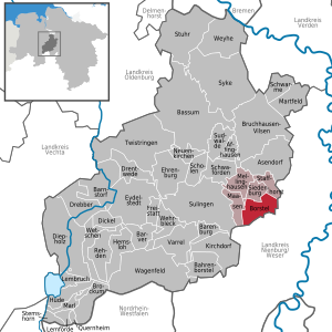
| Location of the Borstel community in the Diepholz district | ||
  |
||

Borstel ( Low German : Bössel ) is a municipality in the Diepholz district in Lower Saxony . It belongs to the Samtgemeinde Siedenburg in which its administrative headquarters in spots Siedenburg has.
geography
Borstel is located between the Wildeshauser Geest Nature Park and the Steinhuder Meer Nature Park, roughly halfway between Bremen and Minden , directly on the B 214 between Sulingen and Nienburg / Weser .
The neighboring communities of Siedenburg , Staffhorst , Wietzen , Pennigsehl , Voigtei and Maasen are located clockwise .
The four districts of the municipality are:
- Bockhop
- Borstel
- Camp
- Simmering (this also includes shame ways)
Three nature reserves extend south-east of Borstel :
- The 495 ha large Borsteler Moor
- the 825 hectare Siedener Moor
- the 633 hectare high moor .
history
The community was first mentioned in a document in 1302.
On March 1, 1974, the communities Bockhop, Campen and Sieden were incorporated.
politics
City council and mayor
The Borstel town council is made up of 11 councilors. (Status: local election on September 11, 2016)
The honorary mayor Dieter Engelbart was elected on September 9, 2001.
coat of arms
Blazon : The coat of arms of the community shows in black a golden post covered with a black kettle hook , in each of the flanks a silver halberd with a golden handle, the edges facing outwards.
Culture and sights
- The Dutch windmill Reina Roxana from 1864 is no longer in operation today, but is still a landmark of Borstel that can be seen from afar.
- The St. Nicolaikirche, first mentioned in 1699, is a single-aisled late Romanesque hall church and the oldest surviving building in Borstel.

Dutch windmill Reina Roxana from 1864

St. Nicolaikirche

Town view I

Town view II

War memorial

War memorial in Bockhop


Economy and Infrastructure
The community is located directly on the federal highway 214, which leads from Diepholz to Nienburg / Weser.
Others
- In 2016, the district youth fire brigade tent camp of the Diepholz district took place in Borstel for the first time.
Web links
Individual evidence
- ↑ State Office for Statistics Lower Saxony, LSN-Online regional database, Table 12411: Update of the population, as of December 31, 2019 ( help ).
- ^ Federal Statistical Office (ed.): Historical municipality directory for the Federal Republic of Germany. Name, border and key number changes in municipalities, counties and administrative districts from May 27, 1970 to December 31, 1982 . W. Kohlhammer GmbH, Stuttgart / Mainz 1983, ISBN 3-17-003263-1 , p. 200 .
- ↑ http://www.wahlen.siedenburg-online.de/10/kw2016/wahlhtml.html
- ↑ Info from www.niedersaechsische-muehlenstrasse.de
- ↑ [1]
Affinghausen | Asendorf | Bahrenborstel | Barenburg | Barnstorf | Barver | Bassum | Borstel | Brockum | Bruchhausen-Vilsen | Dickel | Diepholz | Drebber | Drentwede | Ehrenburg | Eydelstedt | Sanctuary | Hemsloh | Hude | Kirchdorf | Lembruch | Lemförde | Maasen | Marl | Martfeld | Mellinghausen | Neuenkirchen | Quernheim | Rehden | Scholen | Schwaförden | Swarms | Siedenburg | Staffhorst | Stem horn | Stuhr | Sudwalde | Sulingen | Syke | Twistringen | Varrel | Wagenfeld | Wehrbleck | Wetschen | Weyhe