Barenburg
| coat of arms | Germany map | |
|---|---|---|

|
Coordinates: 52 ° 37 ' N , 8 ° 48' E |
|
| Basic data | ||
| State : | Lower Saxony | |
| County : | Diepholz | |
| Joint municipality : | Church Village | |
| Height : | 35 m above sea level NHN | |
| Area : | 16.39 km 2 | |
| Residents: | 1239 (Dec. 31, 2019) | |
| Population density : | 76 inhabitants per km 2 | |
| Postal code : | 27245 | |
| Area code : | 04273 | |
| License plate : | DH, SY | |
| Community key : | 03 2 51 004 | |
| LOCODE : | DE BR5 | |
| Association administration address: | Rathausstrasse 12 27245 Kirchdorf |
|
| Website : | ||
| Mayor : | Hermann Dencker ( non-party ) | |
| Location of the municipality of Barenburg in the district of Diepholz | ||
Barenburg ( Low German : Baarnborg ) is a town in the Diepholz district in Lower Saxony . The patch belongs to the municipality of Kirchdorf , which has its administrative seat in the village of Kirchdorf .
geography
Geographical location
Barenburg is located between the Dümmer Nature Park and the Steinhuder Meer Nature Park, roughly halfway between Bremen and Minden , six kilometers south of Sulingen .
Neighboring communities
| City of Sulingen |
||
| Varrel municipality |

|
District of Nienburg / Weser |
| Kirchdorf parish |
Rivers
From Barenburg, the Kleine Aue, coming from Sulingen, flows with the Große Aue to the east, to flow into the Weser south of Nienburg .
history
The community was first mentioned in a document in 1247. In 1285 a Barenburg castle appears in a document, which in 1338 passed with the rule of Altbruchhausen to the county of Hoya . The castle controlled the old Minden-Bremen road, which ran through a swampy valley here. In 1434 Duke Wilhelm zu Braunschweig-Lüneburg conquered the Barenburg. It was then pledged several times and finally expired. The later Hanoverian Amt Barenburg , which emerged from the Bailiwick of Barenburg and only encompassed the area, was administered from 1706 together with the Amt Ehrenburg and in 1823 it was merged with the Amt Ehrenburg-Barenburg. The town of Barenburg first appeared as a patch in 1530.
politics
Municipal council
The local council from Barenburg consists of eleven councilors and councilors who all belong to the Barenburg electoral community. (Status: local election on September 11, 2016)
mayor
On February 21, 2018, Hermann Dencker was elected by the local council as honorary mayor of the Flecken Barenburg.
Previous incumbents:
- 1952–1976: Heinrich Dencker
- 1976-1991: Kurt Kothrade
- 1991–2006: Heinrich Kammacher
- 2006-21. February 2018: André Meyer
- since February 21, 2018: Hermann Dencker
coat of arms
Blazon : The coat of arms of the municipality shows in blue on green ground a (heraldically) right-facing naturally striding, yellow and black spotted leopard.
Culture and sights
In the competition " Our village has a future ", Barenburg took 3rd place in the district of Diepholz together with the Syker district of Wachendorf .
Buildings
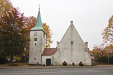
Barenburg Church , with parts of the wall of the Chapel of the Holy Cross from the twelfth century
Jewish Cemetery
The Jewish cemetery in Barenburg is a cultural monument . It is one of eight well-preserved Jewish cemeteries in the Diepholz district. In the cemetery on the street “Zum Bahnhof” there are 49 gravestones from the years 1828 to approx. 1938 for the Jewish deceased.
economy
In Barenburg is the oil field Barenburg of ExxonMobil .
traffic
Street
The community is located directly on the federal highway 61 , which leads from Minden to Sulingen .
Rail transport
Barenburg has a rail connection to the Diepholz-Sulingen railway line . This is used by tankers for ExxonMobil ( petroleum ) based in Barenburg . The siding forms the rest of the formerly continuous Rahden-Sulingen-Bassum railway line . The tracks from Barenburg to Rahden were shut down in 1997 and are no longer passable today.
Personalities
- Rolf Kramer (* 1949), politician born in Barenburg, member of the Bundestag
literature
- Nancy Kratochwill-Gertich: Barenburg. In: Herbert Obenaus (Ed. In collaboration with David Bankier and Daniel Fraenkel): Historical manual of the Jewish communities in Lower Saxony and Bremen . Volume 1 and 2 (1668 pp.), Göttingen 2005, pp. 159-164
- Helmut Hark [Hrsg.]: The history of the patch and the parish of Barenburg . Plenge, Sulingen / Hanover, 1970.
- BARENBURG. In: Georg Dehio : Handbook of German Art Monuments . Bremen Lower Saxony. Deutscher Kunstverlag, Munich / Berlin 1992, ISBN 3-422-03022-0 , p. 188
Individual evidence
- ↑ State Office for Statistics Lower Saxony, LSN-Online regional database, Table 12411: Update of the population, as of December 31, 2019 ( help ).


