Martfeld
| coat of arms | Germany map | |
|---|---|---|

|
Coordinates: 52 ° 53 ' N , 9 ° 4' E |
|
| Basic data | ||
| State : | Lower Saxony | |
| County : | Diepholz | |
| Joint municipality : | Bruchhausen-Vilsen | |
| Height : | 12 m above sea level NHN | |
| Area : | 35.06 km 2 | |
| Residents: | 2801 (Dec. 31, 2019) | |
| Population density : | 80 inhabitants per km 2 | |
| Postal code : | 27327 | |
| Area code : | 04255 | |
| License plate : | DH, SY | |
| Community key : | 03 2 51 026 | |
| Association administration address: | Lange Str. 11 27305 Bruchhausen-Vilsen |
|
| Website : | ||
| Mayor : | Marlies Plate (Alliance 90 / The Greens) | |
| Location of the community Martfeld in the district of Diepholz | ||
The community Martfeld ( Low German : Mattfeld ) belongs to the combined community of Bruchhausen-Vilsen in the Lower Saxony district of Diepholz . The population is around 2700.
geography
Geographical location
Martfeld is about 30 km south of Bremen .
Neighboring communities
Neighboring communities are Schwarme , Bruchhausen-Vilsen , Blender, Hilgermissen and Hoya.
Community structure
The following districts belong to Martfeld:
- Martfeld
- Hustedt, a small district, has a village community center, a shooting range and a model airplane field.
- Small bristle
- Lodge
- Tuschendorf
history
The place was first mentioned in 1179 in a papal document, which Pope Alexander III. personally signed.
The yard place mentioned in the document "... CURTIS in MERDVELDE cum CAPELLA et PERTINENTIIS SUIS ..." (translated: "yard in Martfeld with chapel and accessories") with its adjoining pastureland and forest (the "Echterkamp") still defines the image of the town center today. In addition, there was a long-running “war” against the neighboring community Schwarme, which is commemorated by a memorial that stands exactly between the two place-name signs. Back then it was about the heath, which today belongs to Martfeld.
Incorporation:
On March 1, 1974, the communities of Hustedt and Kleinenborstel were incorporated.
politics
Municipal council
The Martfeld community council is made up of 13 councilors.
- SPD - 3 seats
- CDU - 2 seats
- Green - 4 seats
- Flat share independent list Martfeld - 4 seats
(Status: local election on September 11, 2016)
coat of arms
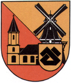
Blazon : obliquely divided by gold and red; Above a black windmill, below a single-towered golden church with black roofs, on the lower left a golden shield with a floating black house brand inside, this consisting of two diagonally crossed angles with turned away, shortened legs, which are connected to a triangle with a beam cut diagonally on both sides are.
Community partnerships
- La Bazoge in France
Culture and sights
Buildings
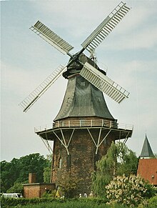
- The Martfeld field mill was first mentioned in 1583. The post mill was sold to an ancestor of the current owner in 1827. In 1840 it was converted into a three-story Dutch gallery. This burned down completely after a lightning strike in 1851 and was rebuilt in the same year. In 1957 the wings, the compass rose and the turntable were removed. The renovation of the mill began in 1992, the exterior was completely restored in 1997 and the interior work was completed in 1999. The mill is the oldest windmill in the Samtgemeinde.
- In 1871 the Fehsenfeldsche Mühle was built as a three-story gallery Dutchman. The mill was sold in 1904 due to a lack of customers. The grinding operation was maintained until 1971. The mill was restored in 1991, the four grinding stages have been preserved. The mill is used for "mill weddings".
theatre
- Every year a Low German theater took place in the Gasthaus Soller. (Inn and theater stage closed since 2018.)
- In 1997 the chestnut was put into operation as a theater restaurant. Numerous concerts and theater events take place in this cabaret.
Art in public space
- In the village square from place since 1999 stainless steel designed sculpture unfolding of Syker artist Elsa Töbelmann and Henning Greve .
"Colorful paths"
- Working group of the Home and Beautification Association (HVV)
- Preservation and care of colorful roadsides, bank strips, hedges and also fields. Implementation of various campaigns such as the "Martfeld Staudentage".
Economy and Infrastructure
Public facilities
There is a nursing home in Martfeld. The closest hospitals are the Aller-Weser Clinic in Verden (Aller) and the Bassum Clinic (to the St. Ansgar Clinic Association ).
education
- There is a primary school with grades 1-4.
Personalities
- Friedrich Joloff (1908–1988), actor , radio play and voice actor , spent his old age in a nursing home in the Kleinenborstel district
- Dietrich Leiding (1925–2005), politician
- Burchard Bösche (1946–2019), lawyer , trade unionist and author
- Heinrich Gräpel (* 1951), agricultural scientist and university professor
- Heinz-Dieter Freese (* 1957), pastor and aerial photo archaeologist
- Anke Habekost (* 1962), translator and writer of theater texts, grew up in Martfeld
- Michael Albers (1966), politician
Web links
- Official website of Martfeld
- Integrated community of Bruchhausen-Vilsen
- Historical postcards from Martfeld
Individual evidence
- ↑ State Office for Statistics Lower Saxony, LSN-Online regional database, Table 12411: Update of the population, as of December 31, 2019 ( help ).
- ^ Federal Statistical Office (ed.): Historical municipality directory for the Federal Republic of Germany. Name, border and key number changes in municipalities, counties and administrative districts from May 27, 1970 to December 31, 1982 . W. Kohlhammer GmbH, Stuttgart / Mainz 1983, ISBN 3-17-003263-1 , p. 191 .
- ↑ PC-Wahl HTML-Modul, vote iT GmbH: Election result of the Martfeld municipal election 2016. Accessed on May 27, 2017 .


