
Varrel
| coat of arms | Germany map | |
|---|---|---|

|
Coordinates: 52 ° 37 ' N , 8 ° 44' E |
|
| Basic data | ||
| State : | Lower Saxony | |
| County : | Diepholz | |
| Joint municipality : | Church Village | |
| Height : | 34 m above sea level NHN | |
| Area : | 43.83 km 2 | |
| Residents: | 1514 (Dec. 31, 2019) | |
| Population density : | 35 inhabitants per km 2 | |
| Postal code : | 27259 | |
| Area code : | 04274 | |
| License plate : | DH, SY | |
| Community key : | 03 2 51 043 | |
| Community structure: | 3 districts | |
| Website : | ||
| Mayor : | Heinrich Hustedt | |
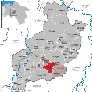
| Location of the municipality of Varrel in the district of Diepholz | ||
  |
||

Varrel is a municipality in the Diepholz district in Lower Saxony .
Geographical location
The villages of Brümmerloh and Dörrieloh also belong to Varrel . 1,700 people live in the municipality on an area of 4,383 hectares. It is a member municipality of the combined municipality of Kirchdorf , which has its administrative seat in the village of Kirchdorf .
history
The name Varrel is said to have originated from the Low German term fort for transit .
Varrel was first mentioned in a document in 1232 . The sexton's house from 1832 also served as a school until 1982 and for cultural purposes since 1991. A major fire in 1869 destroyed the old Varrel church as well as 35 surrounding buildings and important documents. The Marienkirche dates from 1871. Until about 1880 there was a secondary customs office in Varrel, later a main customs office.
After the Second World War, displaced persons from East Prussia and Silesia as well as families of German descent from Bessarabia found a home here.
Incorporations
On March 1, 1974, the municipality of Dörrieloh was incorporated.
politics
Municipal council
The municipal council from Varrel consists of 11 councilors.
- UWG 11 seats
(Status: local election on September 11, 2016)
mayor
Heinrich Hustedt has been honorary mayor of the municipality of Varrel since 2011. Armin Tiemann was the municipal director from 1974 to 2004.
Previous incumbents:
- 1974–1991: Fritz Speckmann
- 1991–2011: Ortwin Stieglitz
- since 2011: Heinrich Hustedt
coat of arms
Blazon : The coat of arms of the municipality of Varrel shows a red corrugated shield base split by blue and gold, in front a gold adjoining cross and behind a blue stylized tree; in the base of the shield a golden flight group.
Culture and sights

- The St. Marienkirche is a neo-Gothic brick building . It was built in 1870/71 according to plans by Conrad Wilhelm Hase . The outer walls of a previous building that burned down in 1869 were used. The chalice-shaped octagonal baptismal font comes from the 15th century, the other interior fittings ( pulpit , organ , stalls) from the time the church was rebuilt.
- The sexton's house is located in the ensemble with the church in the town center and has been used for cultural events since 1991. It was originally the old school and sexton house, which was built until 1833. The primary school in Varrel was located in the premises until 1982. On the initiative of the Kultur im Küsterhaus association, the building was completely renovated in 1989.
Infrastructure
- Varrel High School, Wehrblecker Strasse 2
- Sparkasse Varrel, Hohe Strasse 13
- The station Varrel (Han) was due to the Bassum-Herford railway which now in this area shut down is.
Web links
Individual evidence
- ↑ State Office for Statistics Lower Saxony, LSN-Online regional database, Table 12411: Update of the population, as of December 31, 2019 ( help ).
- ↑ https://www.kreiszeitung.de/lokales/diepholz/wenn-erinnerungen-wehtun-2903454.html
- ^ Federal Statistical Office (ed.): Historical municipality directory for the Federal Republic of Germany. Name, border and key number changes in municipalities, counties and administrative districts from May 27, 1970 to December 31, 1982 . W. Kohlhammer GmbH, Stuttgart / Mainz 1983, ISBN 3-17-003263-1 , p. 189 .
- ↑ VARREL Kr. Diepholz. Ev. Church. In: Georg Dehio : Handbook of German Art Monuments . Bremen Lower Saxony. Deutscher Kunstverlag, Munich / Berlin 1992, ISBN 3-422-03022-0 , p. 1291 f.
- ^ The sexton's house in Varrel - the house
Affinghausen | Asendorf | Bahrenborstel | Barenburg | Barnstorf | Barver | Bassum | Borstel | Brockum | Bruchhausen-Vilsen | Dickel | Diepholz | Drebber | Drentwede | Ehrenburg | Eydelstedt | Sanctuary | Hemsloh | Hude | Kirchdorf | Lembruch | Lemförde | Maasen | Marl | Martfeld | Mellinghausen | Neuenkirchen | Quernheim | Rehden | Scholen | Schwaförden | Swarms | Siedenburg | Staffhorst | Stem horn | Stuhr | Sudwalde | Sulingen | Syke | Twistringen | Varrel | Wagenfeld | Wehrbleck | Wetschen | Weyhe