
Ehrenburg (Lower Saxony)
| coat of arms | Germany map | |
|---|---|---|

|
Coordinates: 52 ° 45 ' N , 8 ° 42' E |
|
| Basic data | ||
| State : | Lower Saxony | |
| County : | Diepholz | |
| Joint municipality : | Schwaförden | |
| Height : | 49 m above sea level NHN | |
| Area : | 48.97 km 2 | |
| Residents: | 1475 (Dec. 31, 2019) | |
| Population density : | 30 inhabitants per km 2 | |
| Postal code : | 27248 | |
| Area code : | 04275 | |
| License plate : | DH, SY | |
| Community key : | 03 2 51 015 | |
| Association administration address: | Poststrasse 157 27252 Schwaförden |
|
| Mayor : | Hans-Jürgen Schumacher ( WUL ) | |
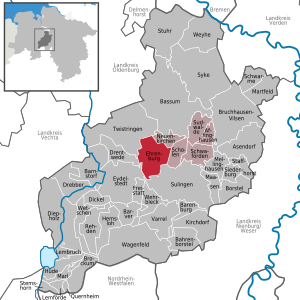
| Location of the municipality of Ehrenburg in the district of Diepholz | ||
  |
||

Ehrenburg ( Low German : Ehrenborg ) is a municipality in the Diepholz district in Lower Saxony . It belongs to the combined municipality of Schwaförden , which has its administrative seat in the municipality of Schwaförden .
geography
Geographical location
Ehrenburg is located south of the Wildeshauser Geest Nature Park, roughly halfway between Bremen and Osnabrück . The Bruchwald near Ehrenburg is nearby.
Community structure
Schmalförden , Schweringhausen , Stocksdorf and Wesenstedt are districts of the municipality of Ehrenburg.
Neighboring communities
| City of Twistringen |
Municipality Neuenkirchen |
|
| Drentwede municipality |
.svg)
|
community Scholen |
| Eydelstedt municipality |
City of Sulingen |
climate
Temperate maritime climate influenced by humid northwest winds from the North Sea. On a long-term average, the air temperature in Ehrenburg reaches 8.5 ° –9.0 ° C, and around 700 mm of precipitation falls. Between May and August, an average of 20-25 summer days (climatological term for days on which the maximum temperature exceeds 25 ° C) can be expected.
history
Coat of arms and seal
An official seal from the 18th century shows two bear paws (symbolizing belonging to County Hoya) and the three towers of the Ehrenburg.
The coat of arms is from modern times and was only approved in 1985. The scales in the lower part symbolize the court, which was located until 1859. In the upper part, the fortress (castle) is stylized from an official seal.
dish
The Ehrenburg court is mentioned from 1447. The Counts of Hoya or their officials spoke right here. In 1859 the court was dissolved and moved to Sulingen. Until then, the Ehrenburg district included the towns of Twistringen, Heiligenloh, Neuenkirchen, Schmalförden, Scholen, Schwaförden, Sulingen, Varrel and Barenburg.
The Ehrenburg
.jpg)
The place was named after the Ehrenburg buried in the forest. It already existed in the 14th century and was under the rule of the County of Altbruchhausen (today Bruchhausen-Vilsen), which passed to the County of Hoya in the middle of the 14th century . The Ehrenburg was destroyed during the Hildesheim collegiate feud . In 1546 the Counts of Hoya rebuilt the castle as a strong fortress, as it was a border castle against the Niederstift Münster. The Nienburg-Vechta road could be controlled with the castle. The castle was damaged again in the Thirty Years' War , but the Merian engraving from 1654 already shows a castle that was repaired as a splendid Drostei. This later fell into disrepair, because around 1740 a new, electoral Hanoverian office building was built a few hundred meters west of the castle on the estate.
Sulingen, as its most important place, was part of the comparatively large office . In 1828 the Barenburg office was attached to Ehrenburg. The Hanoverian office of Ehrenburg was taken over by the newly formed office of Sulingen in 1852. The office building in Ehrenburg later disappeared, the former castle can only be located today using the castle hill.
local community
On March 1, 1974, the previously independent communities Schweringhausen , Stocksdorf and Wesenstedt were incorporated into the community of Schmalförden . On April 27, 1976, this community was officially renamed Ehrenburg .
Evangelical Church in Schmalförden
- The early Gothic hall church of St. Nicholas of brick with their square choir dates back to the third quarter of the 13th century.
Interpretation of the place name
Old names of the place are 1427 Ernborg, 1470 Erenborch, 1512 Der Ernnborg, 1520 and 1583 Erenburg (k). The place name goes back to a castle. In view of the medieval-knightly code of honor, it makes sense to see “ere” for “honor” in the first part of the name in Middle Low German. Another interpretation is based on the Middle Low German "eren" from "Erz", "Ehern", so that it could be called an iron castle.
politics
Municipal council
The council of the municipality of Ehrenburg is composed of eleven members.
| CDU | SPD | WUL | WGE | Green | total | |
| 2016 | 4th | 2 | 3 | 2 | 0 | 11 seats |
Status: Local elections on September 11, 2016
mayor
The honorary mayor Hans-Jürgen Schumacher was elected on February 3, 2004.
traffic
To the east of the community runs the federal road 61 , which leads from Bassum to Minden , about five kilometers away .
To the west of the community there is also the federal road 51 , which runs from Twistringen to Bremen and Osnabrück , about 8 km away .
literature
- Hans Gerke : Ehrenburg. A home book for the communities of Anstedt, Cantrup, Neuenkirchen, Rathlosen, Schmalförden, Scholen, Schweringhausen, Stocksdorf and Wesenstedt. Sulingen 1972
- Heimatverein Kirchspiel Schmalförden: Parish Schmalförden. 1239-1989. A home book. Sulingen 1989
- Heimatverein Kirchspiel Schmalförden: Parish Schmalförden. Courtyards - families - corridors. Heimatbuch 2. Sulingen 1994
Web links
- Website of the municipality of Ehrenburg
- Website of the joint community
- Entry by Stefan Eismann zu Ehrenburg in the scientific database " EBIDAT " of the European Castle Institute
Individual evidence
- ↑ State Office for Statistics Lower Saxony, LSN-Online regional database, Table 12411: Update of the population, as of December 31, 2019 ( help ).
- ↑ Ehrenburg - disappeared castle ( Memento of the original from September 14, 2010 in the Internet Archive ) Info: The archive link was inserted automatically and has not yet been checked. Please check the original and archive link according to the instructions and then remove this notice. .
- ^ Federal Statistical Office (ed.): Historical municipality directory for the Federal Republic of Germany. Name, border and key number changes in municipalities, counties and administrative districts from May 27, 1970 to December 31, 1982 . W. Kohlhammer, Stuttgart / Mainz 1983, ISBN 3-17-003263-1 , p. 189 f .
- ^ Jürgen Udolph (research): The "place name researcher". In: website NDR 1 Lower Saxony . Archived from the original on December 3, 2016 ; accessed on August 4, 2019 .
Affinghausen | Asendorf | Bahrenborstel | Barenburg | Barnstorf | Barver | Bassum | Borstel | Brockum | Bruchhausen-Vilsen | Dickel | Diepholz | Drebber | Drentwede | Ehrenburg | Eydelstedt | Sanctuary | Hemsloh | Hude | Kirchdorf | Lembruch | Lemförde | Maasen | Marl | Martfeld | Mellinghausen | Neuenkirchen | Quernheim | Rehden | Scholen | Schwaförden | Swarms | Siedenburg | Staffhorst | Stem horn | Stuhr | Sudwalde | Sulingen | Syke | Twistringen | Varrel | Wagenfeld | Wehrbleck | Wetschen | Weyhe