
Siedenburg
| coat of arms | Germany map | |
|---|---|---|

|
Coordinates: 52 ° 42 ' N , 8 ° 56' E |
|
| Basic data | ||
| State : | Lower Saxony | |
| County : | Diepholz | |
| Joint municipality : | Siedenburg | |
| Height : | 39 m above sea level NHN | |
| Area : | 14.22 km 2 | |
| Residents: | 1265 (Dec. 31, 2019) | |
| Population density : | 89 inhabitants per km 2 | |
| Postal code : | 27254 | |
| Area code : | 04272 | |
| License plate : | DH, SY | |
| Community key : | 03 2 51 034 | |
| LOCODE : | DE 74K | |
| Association administration address: | Avenue 4 | |
| Website : | ||
| Mayor : | Detlef Metzlaff ( WS ) | |
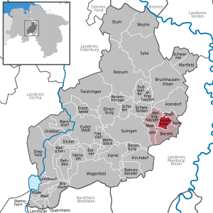
| Location of the community Siedenburg in the district of Diepholz | ||
  |
||


Siedenburg is, together with the district Päpsen, a spot in the Lower Saxony district of Diepholz .
geography
Siedenburg lies between the Wildeshauser Geest Nature Park and the Steinhuder Meer Nature Park, roughly halfway between Nienburg / Weser and Sulingen . The municipality is the administrative seat of the joint municipality Siedenburg , with the places Borstel , Maasen , Mellinghausen , Siedenburg and Staffhorst .
The Siede flows through Siedenburg . It gives the place its name.
history
Siedenburg Castle was first mentioned in 1294 in the chronicle of Landdrosten Marquard von Hodenburg, who used the lost Bücken annals . At that time the fortress was conquered and also regained. At the same time, the Flecken Siedenburg may have developed in front of the moated castle, but it still belonged to the Mellinghausen parish. From 1372 the Counts of Hoya appear as rulers, who often pledged the Siedenburg Palace and Bailiwick. In 1582 the castle, office and spots of Siedenburg, together with the County of Hoya, changed to the Duchy of Braunschweig-Lüneburg .
Until 1932, the Siedenburg area belonged to the Sulingen district , then to the Grafschaft Diepholz district . Since August 1st, 1977 the place belongs to the district of Diepholz .
On March 1, 1974, the neighboring community of Päpsen was incorporated.
politics
Municipal council
The municipal council from Siedenburg consists of eleven members of the Siedenburg electoral community. (Status: local election on September 11, 2016)
mayor
The honorary mayor Detlef Metzlaff was elected on November 7, 2016. The community director is Mayor Rainer Ahrens.
- previous incumbent
- until 2016: Arnold Runge (WS)
coat of arms
Blazon : "In a golden shield a long-stalked three-leaf clover, resting between two upright, averted, red-armored black bear paws connected by breast fur."
The coat of arms of the patch goes back to the neighboring lords of Staffhorst. In the 15th century, representatives of this noble family from Hoya sat as pawns and drosten at Siedenburg Castle. Possibly the stain owes a (not preserved) privilege to a Drosten von Staffhorst, as the heraldry of all other Hoyas cities and stains is characterized by the fact that they have the bear paw (single or double) - the coat of arms of the Counts of Hoya - in the coat of arms.
Economy and Infrastructure

The municipality is located in the immediate vicinity of the federal highway 214 between Sulingen and Nienburg / Weser .
Personalities
- Friedrich Husmann (1877–1950), teacher and local poet in Bremerhaven
Web links
Individual evidence
- ↑ State Office for Statistics Lower Saxony, LSN-Online regional database, Table 12411: Update of the population, as of December 31, 2019 ( help ).
- ^ Federal Statistical Office (ed.): Historical municipality directory for the Federal Republic of Germany. Name, border and key number changes in municipalities, counties and administrative districts from May 27, 1970 to December 31, 1982 . W. Kohlhammer, Stuttgart / Mainz 1983, ISBN 3-17-003263-1 , p. 189 .
- ↑ http://www.wahlen.siedenburg-online.de/40/kw2016/wahlhtml.html
Affinghausen | Asendorf | Bahrenborstel | Barenburg | Barnstorf | Barver | Bassum | Borstel | Brockum | Bruchhausen-Vilsen | Dickel | Diepholz | Drebber | Drentwede | Ehrenburg | Eydelstedt | Sanctuary | Hemsloh | Hude | Kirchdorf | Lembruch | Lemförde | Maasen | Marl | Martfeld | Mellinghausen | Neuenkirchen | Quernheim | Rehden | Scholen | Schwaförden | Swarms | Siedenburg | Staffhorst | Stem horn | Stuhr | Sudwalde | Sulingen | Syke | Twistringen | Varrel | Wagenfeld | Wehrbleck | Wetschen | Weyhe