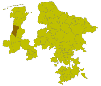
Aschendorf district
| Basic data | |
|---|---|
| Prussian Province | Hanover |
| Administrative district | Osnabrück |
| Circular seat | Aschendorf |
| Inventory period | 1885-1932 |
| surface | 559.94 km² |
| Residents | 25,838 (1925) |
| Population density | 46 inhabitants / km² (1925) |
| Communities | 33 |
| License plate : | IS |
| Location of the district in the former province of Hanover (1905) | |

|
|
| The district before the Prussian territorial reform | |

|
|
The Aschendorf district was a district in the west of the Prussian province of Hanover from 1885 to 1932 .
geography
The district belonged to the Hanoverian Emsland , the Ems shaped the district, it was the main artery. The Friesische Strasse, an old long-distance trade route between Emden and Münster , ran parallel to the west of the Ems . In the north the district bordered on the former Weener and Leer districts , in the east on the district Hümmling , in the south on the district Meppen and in the west on the Kingdom of the Netherlands .
history
After the annexation of the Kingdom of Hanover in 1867 by Prussia , the Aschendorf district was formed in 1885 from the Aschendorf office and the city of Papenburg . Before 1815, the district was part of the Duchy of Arenberg-Meppen , which was created in 1803 from parts of the Lower Monastery of Münster in 1803.
By a regulation of the Prussian State Ministry of August 1, 1932, the Aschendorf and Hümmling districts were dissolved with effect from October 1, 1932 and merged into the Aschendorf-Hümmling district . The communities of Emen and Tinnen , which had belonged to the Aschendorf district up to this point , were incorporated into the Meppen district. Today the area of the former Aschendorf district is part of the Emsland district that was established in 1977 .
Population development
| year | Residents |
|---|---|
| 1890 | 20,307 |
| 1900 | 21,581 |
| 1910 | 23,679 |
| 1925 | 25,838 |
District administrators
- 1885–1889 Heinrich Korte zu Nienhaus
- 1889–1923 Hermann Hassenkamp
- 1923–1932 Georg Behnes
Communities
The following list contains the municipalities of the Aschendorf district with the population as of December 1, 1910:
|
literature
- Werner Franke, Jósef Grave, Heiner Schüpp, Gerd Steinwascher (eds.): The district of Emsland. Geography, history, present. A circle description. Meppen 2002, 931 pages ISBN 3-930365-13-8
- Karl-Eberhard Nauhaus: The Emsland in the course of history. Sögel 1984 ISBN 3-925034-00-5
Web links
- Aschendorf district administrative history and the district administrators on the website territorial.de (Rolf Jehke), as of April 27, 2014.
Individual evidence
- ^ Michael Rademacher: German administrative history. (No longer available online.) Archived from the original on March 4, 2016 ; accessed on January 2, 2015 . Info: The archive link was inserted automatically and has not yet been checked. Please check the original and archive link according to the instructions and then remove this notice.
- ^ Uli Schubert: German community register 1910. Accessed on March 8, 2014 .