
Kluse (Emsland)
| coat of arms | Germany map | |
|---|---|---|

|
Coordinates: 52 ° 56 ' N , 7 ° 21' E |
|
| Basic data | ||
| State : | Lower Saxony | |
| County : | Emsland | |
| Joint municipality : | Dörpen | |
| Height : | 8 m above sea level NHN | |
| Area : | 25.27 km 2 | |
| Residents: | 1700 (Dec. 31, 2019) | |
| Population density : | 67 inhabitants per km 2 | |
| Postal code : | 26892 | |
| Primaries : | 04963, 04966, 05933 | |
| License plate : | Tbsp | |
| Community key : | 03 4 54 025 | |
| Association administration address: | Main street 25 26892 Dörpen |
|
| Website : | ||
| Mayor : | Hermann Borchers ( CDU ) | |
| Location of the municipality of Kluse in the Emsland district | ||
 |
||

Kluse is a municipality in the integrated municipality of Dörpen in the Emsland district in western Lower Saxony .
geography
location
The municipality of Kluse is located on the Ems ten kilometers east of the Dutch border, about halfway between the district town of Meppen in the south and the city of Papenburg in the north. The community is dominated by agriculture.
Neighboring communities
Neighboring communities in the north are the community Dörpen , in the east the community Wippingen , in the south the communities Renkenberge , Fresenburg and Sustrum in the combined community Lathen , in the west the communities Walchum and Dersum .
history
Ahlen Castle (from 1387 AD) was the ancestral seat of a family of the same name. Otto von Ahlden (= Ahlen), a knight of Düthe by trade, was the first of the family to be documented on February 5, 1387.
The southern neighboring community of Renkenberge was also named Kluse from its foundation on September 1, 1934 to September 6, 1938 .
Place name
Kluse station existed before. The name Kluse was chosen for the station because there is a hermitage, in Low German "Kluse", near the station, near which the horses of the stagecoaches used to be exchanged.
Origin of the community
Since January 1, 1965, the municipalities of Ahlen and Steinbild formed the joint municipality of Kluse. The municipality of Kluse was created through the merger of the formerly independent municipalities of Steinbild and Ahlen during the regional reform in Lower Saxony that came into force on January 1, 1973 .
politics
Municipal council
The local council in Kluse is composed of eleven councilors from the following parties:
(Status: local election September 11, 2016)
mayor
The mayor of the municipality of Kluse is Hermann Borchers (CDU). He was confirmed for a fourth term in November 2016. His deputy is Karl-Hans Harren (CDU).
Culture and sights
Buildings
- The Campe estate is located in the Steinbild district
- The Transrapid test route runs near the village
- The parish church of St. George in the incorporated district of Steinbild is a late Gothic brick building from around 1512
Economy and Infrastructure
traffic
Kluse is located directly on the B 70 , near the A 31 and on the Rheine – Norddeich Mole ( Emsland route ), course book route 395, although the stop was closed a few years ago so that a train station in the neighboring communities of Lathen or Dörpen is now used got to.
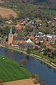 Stone picture on the Ems

Personalities
Sons and daughters of the church
- Emmy von Dincklage (1825-1891), novelist
- Heinrich Leffers (1865–1938), businessman, politician ( center ) and member of the state parliament
- Carl Leffers (1869–1929), businessman, politician (center) and member of the state parliament
- Hermann Lüken-Klaßen (1924–1994), politician (center, CDU), member of the Lower Saxony state parliament
literature
- Hermann Abels: The place names of the Emsland, in their linguistic and cultural-historical significance . Ferdinand Schöningh Verlag, Paderborn 1929.
- Ernst Förstemann, Hermann Jellinghaus (Hrsg.): Old German name book . Place names. tape 2 , no. 2 . Georg Olms Verlag, Hildesheim 1983, ISBN 3-487-01733-4 ( limited preview in the Google book search [accessed on April 21, 2020] first edition: Eigenverlag, Nordhausen 1872).
- Werner Kaemling: Atlas on the history of Lower Saxony . Gerd J. Holtzmeyer Verlag, Braunschweig 1987, ISBN 3-923722-44-3 .
Web links
Individual evidence
- ↑ State Office for Statistics Lower Saxony, LSN-Online regional database, Table 12411: Update of the population, as of December 31, 2019 ( help ).
- ↑ Michael Rademacher: German administrative history from the unification of the empire in 1871 to the reunification in 1990. District Aschendorf Hümmling ( see under: No. 41 ). (Online material for the dissertation, Osnabrück 2006).
- ↑ a b Jürgen Udolph (research): The "place name researcher". In: Website NDR 1 Lower Saxony . Archived from the original on December 2, 2016 ; accessed on August 5, 2019 .
- ^ Federal Statistical Office (ed.): Historical municipality directory for the Federal Republic of Germany. Name, border and key number changes in municipalities, counties and administrative districts from May 27, 1970 to December 31, 1982 . W. Kohlhammer, Stuttgart / Mainz 1983, ISBN 3-17-003263-1 , p. 252 .
- ^ Result of the municipal elections Kluse 2011. In: Website Samtgemeinde Dörpen. September 11, 2011, accessed April 21, 2020 .
- ↑ a b Result of the municipal election Kluse 2016. In: Website Samtgemeinde Dörpen. September 11, 2016, accessed April 21, 2020 .
- ↑ a b Council of the municipality of Kluse. In: Website Samtgemeinde Dörpen. Retrieved April 21, 2020 .
- ↑ Anna Heidtmann: Hermann Borchers remains mayor in Kluse. In: Website Neue Osnabrücker Zeitung . November 23, 2016, accessed April 21, 2020 .
Andervenne | Bawinkel | Beesten | Bockhorst | Börger | Breddenberg | Dersum | Dohren | Dörpen | Emsbüren | Esterwegen | Freren | Fresenburg | Geeste | Barley | Big Berßen | Handrup | Haren (Ems) | Haselünne | Heede | Heart sheet | Hilkenbrook | Hüven | Small Berßen | Kluse | Loading | Lahn | Long | Lathen | Lehe | Lengerich | Lingen (Ems) | Lorup | Lünne | Meppen | Brass | Neubörger | New marriage | Niederlangen | Oberlangen | Papenburg | Rastdorf | Renkenberge | Roadstead (Ems) | Mountains of salt | Schapen | Sögel | Spahnharrenstätte | Spelle | Stavern | Surwold | Sustrum | Thuine | Twist | Vrees | Walchum | Werlte | Werpeloh | Race | Wippingen