
Beesten
| coat of arms | Germany map | |
|---|---|---|

|
Coordinates: 52 ° 26 ' N , 7 ° 30' E |
|
| Basic data | ||
| State : | Lower Saxony | |
| County : | Emsland | |
| Joint municipality : | Freren | |
| Height : | 32 m above sea level NHN | |
| Area : | 25.63 km 2 | |
| Residents: | 1602 (Dec. 31, 2019) | |
| Population density : | 63 inhabitants per km 2 | |
| Postal code : | 49832 | |
| Area code : | 05905 | |
| License plate : | Tbsp | |
| Community key : | 03 4 54 003 | |
| LOCODE : | DE B9E | |
| Address of the municipal administration: |
Hauptstrasse 26 49832 Beesten |
|
| Mayor : | Werner Achteresch ( CDU ) | |
| Location of the municipality of Beesten in the district of Emsland | ||
 |
||

Beesten is a municipality in the southern district of Emsland and belongs to the combined municipality of Freren .
geography
The municipality of Beesten is located in the southern Emsland on the Große Aa , about 16 kilometers southeast of Lingen and 23 kilometers northwest of Ibbenbüren .
Neighboring communities are Freren in the northeast, Schapen in the southeast, Lünne in the south and west and Messingen in the northeast.
history
In the Middle Ages, Beesten belonged to the County of Tecklenburg . After the defeat of the Tecklenburg Counts in the Schmalkaldic War , Beesten became part of the County of Lingen in 1548 . Under King Friedrich I , Beesten became part of Prussia in 1702 . After the French occupation under Napoleon, Beesten came to the Kingdom of Hanover in 1815 .
Name derivation and local history
The village of Beeston were the peasantry crowd things and tallow-Wilsten affiliated. The oldest farms in Beesten are the Schultenhof in Wilsten, Beestermöller in Schardingen (formerly Beester Möller = owner of a water mill), Meyer, Burrichter and Hamann. A barn owned by the farmer Hamann was formerly called Tennschüre (tithe barn). Here the self-hearing had to pay their taxes ( tithing ).
Beesten (old: Biastun , later Bestene ). Name derivation not clarified. The first mention was made in the year 890 in Lifting registers of Werden Abbey . At that time the place belonged to the Venkigau . Among other things, Waldric supplied 24 bushels of grain and 18 denarii, later Daghvelp 24 bushels of grain, the full army schilling and a quarter. Beesten suffered particularly from the frequent changes in rulership in County Lingen. After the Thirty Years' War , County Lingen was under Dutch / Orange rule for several years. In 1800 the lessons in the school were given in Dutch. It was only between 1850 and 1860 that the use of Dutch became uncommon, and Dutch school books were replaced by German ones.
Some dead people came from Beesten. The Tödden were traveling merchants and peddlers who developed from Holland-goers after the Thirty Years' War , with the heyday in the 18th century, and initially offered their goods in the Netherlands, later also in the Nordic and Baltic countries. The tödden trade brought some prosperity to the home communities, which the tödden houses with their often elaborately designed gables still attest today. There is still a beautiful, old Töddenhaus in the center of Beesten. The normal Dutchmen are to be distinguished from the Tödden, who hired themselves out in large numbers in the Netherlands as grass mowers, peat cutters and farm workers. The high point of the Holland tour was in the second half of the 18th century.
Schardingen . The defining word has the meaning: hairy, furry, scratchy, rough; from indogerm.- skar , -sker , via indogerm.- skars , cf. germ. skarzon , mhd. scherren , ahd. scerran , old saxony . skerran ; names a place of worship of the goddess or hero in an animal form and thus refers to a place of worship. Example: Scharrel, Scharbeutz, Schortens. The basic word -ingen is a place name ending of prehistoric origin and goes back to a settling clan or, more generally, to a settlement.
At Talge-Wilsten , Wilsten (old: Willeshadi, Willeshedi 1000; after 1200 Willsetthen and Willsethen) derivation from the proper name Willo. Talge (old: valley location 1231). Wilsten is mentioned for the first time in the Werdener Urbar around 1000 as part of the Venkigau.
Outsourcing
On March 1, 1974, an area with then around 100 inhabitants was assigned to the neighboring municipality of Lünne .
Population development
When analyzing the population figures, there was a strong decrease in the population between 1800 and 1900. This decrease is caused by a large wave of emigration to America.
| 1800 | 1830 | 1880 | 1900 | 1925 | 1933 | 1939 | 1950 | 2005 | 2015 | |
|---|---|---|---|---|---|---|---|---|---|---|
| Beesten | k. A. | k. A. | 744 | 720 | 910 | 948 | 1118 | 1310 | k. A. | k. A. |
| Talge-Wilsten | k. A. | k. A. | 305 | 313 | 384 | 379 | 556 | 603 | k. A. | k. A. |
| total | 1700 | 1300 | 1049 | 1033 | 1294 | 1327 | 1647 | 1913 | 1695 | 1584 |
politics
Municipal council
The council has 11 councilors. The last local election on September 11, 2011 brought 10 seats for the CDU and 1 seat for an individual applicant.
The 2016 local elections did not result in any change in the distribution of seats.
mayor
In November 2011 Werner Achteresch was elected to succeed Hubert Meiners. Meiners had held the office for 15 years. Achteresch was confirmed in office in the local elections on September 11, 2016. His deputies are Tobias Schnier (CDU) and Ludger Garmann (CDU).
Mayor of the municipality of Beesten
In the municipality of Beesten, which has existed since 1965, the following people were mayors:
- since 2011 Werner Achteresch (CDU)
- 1996–2011 Hubert Meiners (CDU)
- 1980–1996 Karl Pengemann
- 1965–1980 Ewald Beestemöller
Mayor of the former municipality of Beesten-Schardingen
- 1964–1965 Ewald Beestemöller
- 1960–1964 Heinrich Veer
- 1948–1960 August Pengemann
- 1945–1948 Andreas Garmann
- 1938–1945 Gregor Surmann
- 1920–1938 Heinrich Schartmann
- 1908–1920 Heinrich Weemeyer
- 1901–1908 Hermann Kampel
- 1895–1901 Hermann Surmann
- 1889–1895 Hermann Kampel
Mayor of the former municipality of Talge-Wilsten
- 1952–1965 Georg Meiners
- 1946–1952 Franz Krone
- 1933–1946 Bernhard Bunge
- 1921–1933 August Herbers
- 1908–1921 Georg Meiners
coat of arms
Blazon : "In a gold rafters, from the lower edge of four grid as defined oblique red bar, two right and left two, go to the sides of the shield, in the right Obereck a sechsspeichiges, red wheel."
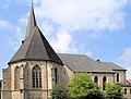
St. Servatius Church
The Beesten parish was formed around 1200 after the unification of the place Beesten and the Schardingen and Talge-Wilsten farmers. The initially small Romanesque church in east-west orientation was considerably enlarged in east and south direction after a Gothicization before 1500 in the first half of the 16th century. Two star vaults , a choir with a polygonal vault and Gothic windows with fish bubbles tracery testify to this .
After the church consecrated to St. Servatius was temporarily closed (prohibition of practicing the Catholic religion in the county of Lingen from 1674), Reformed residents took over the church building. From 1825 the Catholics were allowed to use the church again. During the simultaneous period , which lasted until 1857 , the high altar was made in the Empire style. It contains relics of Saint Simplicius and the companions of Saint Ursula .
Since the growing, almost exclusively Catholic population had hardly any space left in the small church, the old tower from the Middle Ages was torn down in 1874, the church was expanded with another vault in the west direction and a new 50 m high church tower was built. In the 1930s, the church had to be enlarged again: another choir and two sacristy buildings were added to the pierced north wall.

Southwest side of the church
East side of the church

High altar
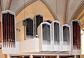
organ


traffic
West of the community runs the Federal Highway 70 and north through Freren and Thuine that bundesstraße 214 . The Rheine-Nord junction is seven kilometers south of the A 30 . The nearest train stations are also in Rheine and Lingen . Until 1969, Beesten also had its own station on the now closed Rheine – Quakenbrück railway line . The old station building still exists. The nearest airport is Münster / Osnabrück Airport, approx. 65 km away .
The Emsland Süd transport association is responsible for local public transport . Beesten is served by bus route 133 and is connected to Lingen almost every hour on school days. Line 195 runs several times a day via Schapen and Spelle to Rheine Bahnhof. Central bus stops are Beesten Dorf (133, 195), Beesten Talge / Wilsten (133) and Beesten Bahnhof (133, 195).
economy
The largest companies with headquarters in Beesten, measured in terms of number of employees and turnover, are:
| Surname | Employee | Sales |
|---|---|---|
| Agricultural engineering and mechanical engineering Schüring GmbH | 210 | € 10,290,533 |
| DP Supply GmbH | 101 | € 12,816,359 |
| Thomsen & Co. GmbH Engine Power Systems | 82 | € 14,088,947 |
| Wilhelm Meese Internationale Spedition und Logistik GmbH | 61 | € 4,304,978 |
| Metalltechnik Wesenberg GmbH | 41 | € 2,009,153 |
| Spieß Rohrleitungsbau GmbH | 30th | Unknown |
| Viehzentrale Beesten-Meppen-Lathen eG | 28 | € 99,868,355 |
| Construction company Matthias Kottmann | 20th | Unknown |
| Nursery Detlef Garmann | 19th | Unknown |
| Corman GmbH | 11 | € 41,475,444 |
literature
- Teachers' Association of the Diocese of Osnabrück - The District of Lingen. Contributions to local studies in the Osnabrück administrative district, volume I , R. van Acken publishing house, Lingen / Ems 1905
- Werner Kaemling - Atlas on the history of Lower Saxony , Gerd J. Holtzmeyer Verlag, Braunschweig 1987, ISBN 3-923722-44-3
- Hermann Abels - The place names of the Emsland, in their linguistic and cultural-historical significance , Ferdinand Schöningh Verlag, Paderborn 1929
- Christoph Oberthür, Franz Busche, Franz Barth, Heinrich Dünheuft - home map of the Lingen district with statistical information , Verlag R. van Acken, Lingen / Ems 1953
- Ernst Förstemann, Hermann Jellinghaus (editor) - Old German name book , Volume II, 1 and 2: Place names , Bonn 1913/1916 (Reprint: Volume II, 2, Hildesheim 1967/1983, ISBN 3-487-01733-4 )
- Josef Garmann, Beestener Chronik 1945–1995, Goldschmidt-Druck GmbH Werlte ISBN 3-927099-43-0
Web links
Individual evidence
- ↑ State Office for Statistics Lower Saxony, LSN-Online regional database, Table 12411: Update of the population, as of December 31, 2019 ( help ).
- ^ Federal Statistical Office (ed.): Historical municipality directory for the Federal Republic of Germany. Name, border and key number changes in municipalities, counties and administrative districts from May 27, 1970 to December 31, 1982 . W. Kohlhammer GmbH, Stuttgart / Mainz 1983, ISBN 3-17-003263-1 , p. 255 .
- ↑ http://www.freren.com/
- ↑ https://www.freren.net/sessionnet/buergerinfo/kp0041.php
- ↑ http://www.noz.de/lokales/freren/artikel/36329/werner-achteresch- Follow-in-beesten-hubert- meiners
- ↑ Mayor or mayor of Beesten-Schardingen ( Memento from December 12, 2008 in the Internet Archive ) Text of the Beesten home association with a list of the mayors of the community
- ↑ St. Servatius Beesten on pfarierendengemeinschaftfreren.de. Retrieved August 7, 2011 .
- ↑ Creditreform company information. Retrieved January 18, 2018 .
Andervenne | Bawinkel | Beesten | Bockhorst | Börger | Breddenberg | Dersum | Dohren | Dörpen | Emsbüren | Esterwegen | Freren | Fresenburg | Geeste | Barley | Big Berßen | Handrup | Haren (Ems) | Haselünne | Heede | Heart sheet | Hilkenbrook | Hüven | Small Berßen | Kluse | Loading | Lahn | Long | Lathen | Lehe | Lengerich | Lingen (Ems) | Lorup | Lünne | Meppen | Brass | Neubörger | New marriage | Niederlangen | Oberlangen | Papenburg | Rastdorf | Renkenberge | Roadstead (Ems) | Mountains of salt | Schapen | Sögel | Spahnharrenstätte | Spelle | Stavern | Surwold | Sustrum | Thuine | Twist | Vrees | Walchum | Werlte | Werpeloh | Race | Wippingen