Wippingen
| coat of arms | Germany map | |
|---|---|---|

|
Coordinates: 52 ° 55 ' N , 7 ° 24' E |
|
| Basic data | ||
| State : | Lower Saxony | |
| County : | Emsland | |
| Joint municipality : | Dörpen | |
| Height : | 14 m above sea level NHN | |
| Area : | 16.54 km 2 | |
| Residents: | 968 (Dec. 31, 2019) | |
| Population density : | 59 inhabitants per km 2 | |
| Postal code : | 26892 | |
| Area code : | 04966 | |
| License plate : | Tbsp | |
| Community key : | 03 4 54 060 | |
| Association administration address: | Main street 25 26892 Dörpen |
|
| Website : | ||
| Mayor : | Hermann Gerdes ( CDU ) | |
| Location of the municipality of Wippingen in the district of Emsland | ||
Wippingen is a municipality of the integrated municipality Dörpen in the district of Emsland in Lower Saxony .
The municipality, which extends over 16.54 km², has 1002 inhabitants . It is characterized by agriculture, many residents are employed as commuters in industry and in the service sector.
geography
Geographical location
Wippingen is located in the northwestern part of the Emsland about 10 km northwest of the Geesthügel des Hümmling . The community is located around 7 km east of the Ems , around 17 km south of Papenburg and around 25 km north of Meppen .
The northern loop of the Emsland Transrapid test facility runs through the northern part of the municipality .
Community structure
The municipality of Wippingen consists of the core town of the same name and Strotburg, its small northern district.
Geology and landscape
The flat area of the municipality consists partly of ice-age sandy soils , partly of cultivated moor , which is drained via the flowing waters of Wippinger Dever and Haar-Dever (on the border to Neubörger in the northeast).
Neighboring communities
Neighboring communities in the north are the communities Dörpen and Neubörger , in the east the communities Börger and Werpeloh in the joint community of Sögel , in the south the community Renkenberge in the joint community Lathen and in the west the community Kluse .
Origin of name
ing , ingen means: coming from, descending from ... ‚but also seems to be used for groups of houses. Wippingen probably from Wübbe, a nickname for Willibald, which can also be found in southern Germany and Switzerland.
history
Wippingen is mentioned for the first time in 1534 in the plow treasure register as burschop tor Wyppinge (Wippingen West); In the same year, two farms are listed in the pension and inheritance lists of the Emsland under "Hymelingen Werplo Burschop" (literally: "Hümmling, Bauerschaft Werpeloh ", the nearest village) (Wippingen Ost). The then existing and probably much older division of the settlement area with its affiliation to different court and administrative districts or parishes and - later - rural districts remained in place for centuries. A municipality of Wippingen existed in both the Aschendorf and Hümmling districts until 1932. After the formation of the Aschendorf-Hümmling district , the two communities were given the names Ostwippingen and Westwippingen to distinguish them . On October 1, 1939, Ostwippingen and Westwippingen merged to form today's municipality of Wippingen.
Parish
Ecclesiastically, Wippingen West belonged to the Steinbild parish , Wippingen Ost to the Sögel parish . On April 1, 1911, the chapel congregation was raised to a curate . Charlemagne, the patron saint of the church built in 1843, was founded in 1952 by St. Bartholomew replaced.
politics
Municipal council
The municipal council in Wippingen consists of 9 councilors. After the local elections on September 11, 2011, two parties belong to it .
mayor
- 1961–1986: Hermann Gerdes
- 1986–1996: Georg Kuper
- 1996-2006: Hermann Hackmann
The honorary mayor Hermann Gerdes (CDU) was elected unanimously on November 16, 2006 and was last confirmed in office in November 2016.
coat of arms
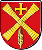
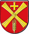
In red a golden inclined windmill wing cross, angled at the top by a golden equal-armed cross, at the bottom by a golden ear of corn (design and execution: Dr. Ulf-Dietrich Korn, Münster, 1998).
The parish church, represented here by a simple cross, and the windmill , represented only by its characteristic winged cross, are the most important elements of the coat of arms, supplemented by the ear as a symbol for the agriculture that predominates in the municipality. The ear of corn also indicates that it belongs to the municipality of Dörpen , which has a sheaf of corn in its coat of arms; a single ear of wheat is accordingly also found in the coat of arms of the municipality of Dörpen.
Red and gold are the colors of the coat of arms of the old duchy of Münster, to whose Niederstift the municipal area belonged until the end of the old empire in 1803.
Economy and Infrastructure
economy
Already the early cattle treasure lists (for example from 1545) show a high livestock with little arable land. Pasture and hat farming with cattle and sheep were and are the predominant forms of operation, but in the 19th century the proportion of grain cultivation was so large that two grain mills could be operated between 1860 and 1887.
traffic
Bundesstrasse 70 ( Papenburg - Meppen ) passes three kilometers west of Wippingen .
Attractions
Two striking buildings characterize the town center: the tower of the old parish church, which was raised in 1896 and was replaced by a new building in 1977, and the Dutch through-mill built in 1860 for a community of interested parties from both districts. It had been shut down since 1937, became the property of the municipality in 1979 and, after its restoration in 1981, was handed over to the Aschendorf-Hümmling Local Authority and Tourist Office for further use and maintenance.
The Emsland Transrapid test facility is also worth seeing, the Nordschleife of which runs through the northern part of the municipality.
Personalities
- Heinrich Schniers (born March 25, 1880 in Wippingen; † August 30, 1942 in Dachau concentration camp ), Catholic clergyman, pastor in Leer , victim of National Socialism
literature
- Werner Kaemling - Atlas on the history of Lower Saxony , Gerd J. Holtzmeyer Verlag, Braunschweig 1987, ISBN 3-923722-44-3
- Hermann Abels - The place names of the Emsland, in their linguistic and cultural-historical significance , Ferdinand Schöningh Verlag, Paderborn 1929
- Ernst Förstemann, Hermann Jellinghaus (editor) - Old German name book , Volume II, 1 and 2: Place names , Bonn 1913/1916 (Reprint: Volume II, 2, Hildesheim 1967/1983, ISBN 3-487-01733-4 )
Web links
Individual evidence
- ↑ State Office for Statistics Lower Saxony, LSN-Online regional database, Table 12411: Update of the population, as of December 31, 2019 ( help ).
- ↑ Michael Rademacher: German administrative history from the unification of the empire in 1871 to the reunification in 1990. District Aschendorf Hümmling. (Online material for the dissertation, Osnabrück 2006).
- ↑ www.doerpen.de
- ↑ http://www.noz.de/lokales/doerpen/artikel/804672/hermann-gerdes-bleibt-buergermeister-in-wippingen


