
Humpback
| Humpback | |
|---|---|
| Highest peak | Windberg ( 73 m above sea level ) |
| location | District of Emsland , Lower Saxony ( Germany ) |
| Coordinates | 52 ° 55 ' N , 7 ° 32' E |
The Hümmling (Homelinghen, from hömil = small stone) is up to 73 m above sea level. NHN high ground moraine landscape ( Geest ) of the North German lowlands . It is located in the west of Lower Saxony in the Emsland district .
geography
location


The Hümmling is located in the north of the Emsland district. Its ridge is just under 10 km from the course of the Ems . Its extension is about 28 km in north-south direction and about 14 km in east-west direction. From the north end it is almost 30 km to Leer in East Frisia . The south end is near Stavern . The highest point, called Windberg, is between Sögel (22 km northeast of Meppen ) and Börger, a little east of Werpeloh .
The largest rivers in the Hümmling are the Ohe , which flows north to the Sater Ems , and the Nordradde , which flows into the Ems at Meppen. The Südradde , which is only partially attributable to the Hümmling, flows into the Hase .
To the north, the Hümmling stands out sharply against the moor area around Sater Ems and Leda, and to the south it runs gently towards the Hasetal. To the east, Geest areas of lower elevation connect to the Thülsfelder Dam . The landscape framework plan of the Emsland district includes them up to the district boundary at Marka and Mittelradde with the Hümmling. These include the Glümmel, which is almost entirely used for agriculture, and to the east of it the forest area of Quäkenberg, Langenberg, Eleonorenwald and Herzogsbusch, and south of it the Wehmer Heide and the Lahner Heide.
The Hümmling is counted as part of the Emsland , mainly due to its political assignment to the district of the same name, which was created in 1977. It is essentially distributed over three municipalities . The largest part belongs to the joint municipality of Sögel , the northern edge to the joint municipality of Nordhümmling , the north around the municipality of Lorup to the joint municipality of Werlte . The south of the natural space unit Sögeler Geest (Hümmling) lying community Lähden is part of herzlake which to Loeningen belonging Wachtum located in the southeast of this natural space unit. The villages of Neubörger and Wippingen , which are part of the combined municipality of Dörpen , are to the northwest outside the Hümmling, and the Friesoyth districts of Gehlenberg and Neuvrees to the north.
Natural allocation
The Hümmling belongs in the natural spatial main unit group Ems-Hunte-Geest (No. 59), in the main unit Sögeler Geest (Hümmling) (592) and in the subunit North-Hümmling (592.1) to the natural areas Börger Sand-Geest (592.11) and Loruper Geestrücken (592.12) and in the subunit Süd-Hümmling (592.2) to the natural area Sögel-Linderner Geest (592.20).
Surveys
The elevations and parcels of land in Hümmling and its immediate surroundings include - with heights in meters (m) above sea level (NHN):
- Windberg (73 m) - east of Werpeloh
- Lüttker Sand (71.6 m) - northeast of Werpeloh
- Sunderberg (66.0 m) - south-southwest of Börger
- Kreuzberg (52 m) - north of Groß Stavern
- Windelberg (49.2 m) - northwest of Börger
- Harrenstätter Sand (approx. 48 m) - between Lorup and Spahnharrenstätte
- Wahner Tannen (46.0 m) - west of Werpeloh
- Bush height (approx. 44 m) - north of Lorup
- Hohenklinken (43.5 m) - west-northwest of Werpeloh
- Bush height (approx. 42 m) - north of Lorup
- Kavenberg (approx. 42 m) - southwest of Lorup
- Wohldhöhe (approx. 45 m) - west of Sögel
- Hamberg (approx. 40 m) - between Lathen and Sögel
- Varel (approx. 39 m) - southwest of Vrees
- Eleonorenhöhe (38.5 m) - between Vrees and Neuvrees in the Eleonorenwald
- Großer Westerberg (approx. 39 m) - between Börger and Neubörger
- Galenberg (approx. 38 m) - near Klein Stavern
- Large dune (34.2 m) - between Lathen and Sögel
- Wattberg (approx. 35 m) - between Börgerwald and Neubörger
- Large dune (30.5 m) - between Meppen and Stavern
- Schlopenberg (approx. 30 m) - northwest of Börger
Flowing waters
The rivers that arise in or near Hümmling include:
- Loruper Beeke , rises in the Hümmling, southeast tributary of the Ohe
- Marka , rises in Hümmling, east of Bockholte right source of Bach Sagter Ems, in the Leda opens
- Mittelradde , rises on the eastern edge of the Hümmling near Bockholte, passes it to the southeast, the northern tributary of the Hase
- Nordradde , rises in the middle of the Hümmlings, at Theikenmeer, northeast tributary of the Ems
- Ohe , rises in the middle part of the Hümmlings, leaves it in a northerly direction, left source brook the Sagter Ems
- Said Ems , arises from the confluence of the Marka and Ohe north of Friesoythe-Neuscharrel
- Südradde , rises east of the Hümmlings, northern tributary of the Hase
Communities
The communities with districts in and on the Hümmling include in terms of their natural spatial allocation :
|
|

Town hall of Meppen

Allee to Clemenswerth
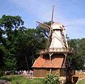
Hüvener mill


Protected areas
Parts of the nature reserve (NSG) Tinner Dose-Sprakeler Heide ( CDDA -Nr. 30115; designated 2012; 39.55 km² ) with the fauna-flora-habitat- area Tinner Dose-Sprakeler Heide (FFH ) extend into the southwest foothills of the Hümmling No. 3110-301; 39.55 km²) and the bird sanctuary (VSG) Tinner Dose-Sprakeler Heide (VSG No. 3110-301; 39.55 km²). Parts of the NSG Leegmoor (CDDA no. 82082; 2009; 4.5 km²) with the FFH area Leegmoor (FFH no. 2911-301; 4.6 km²) and those of the NSG extend to the northern foothills of the landscape Melmmoor / Kuhdammoor (CDDA no. 102318; 1992; 1.28 km²) and the VSG Esterweger Dose (VSG no. 2911-401; 64.41 km²). The landscape includes the NSG Oberlauf der Ohe (CDDA no. 164897; 1990; 2.23 km²), the NSG Schaapmoor (CDDA no. 319053; 1999; 2.1 km²) and the NSG Theikenmeer (CDDA- No. 82708; 1983; 2.5 km²), in which the moor area Dose and the 4 hectare lake Theikenmeer are located. In the Hümmling is also the landscape protection area of the castle and forest facilities Clemenswerth (CDDA no. 324187; 1969; 66.4 ha ).
Geology and landscape
As usual for geest landscapes, the Hümmling mainly consists of barren sandy soils. The most corrugated areas are almost entirely covered with forest. In between there was also heathland , which has largely given way to intensive agriculture. In the flatter eastern and southern parts of the area, agricultural use predominates, with not a small proportion of forest here either. On the south side there are small, moated depressions, the so-called cans, enclosed by a geest . This includes the Bockholter Dose , a small, largely natural raised bog complex.
history

The Hümmling was created by glaciers in the penultimate Ice Age , the Saale Cold Age . When glaciers migrate, they carry debris with them. When it melted, the hilly landscape of the humpback remained. Several more or less well-preserved barrows show that the Hümmling hilly landscape was settled in the Neolithic Age.
In 1252, the Hümmling came as part of the Meppen office through the sale of Jutta von Ravensberg to the Prince Diocese of Münster and thus became part of the Lower Monastery of Münster . The peculiarity of the Niederstiftes, which together with the Oberstift formed the Hochstift Münster , was the secular jurisdiction in Münster, but the ecclesiastical jurisdiction in Osnabrück .
Due to the Reichsdeputationshauptschluss of February 25, 1803, the spiritual territories in the Holy Roman Empire (HRR) were dissolved, and the Meppen office with the Hümmling fell to the Duchy of Arenberg as compensation , which suffered territorial losses from the French Empire in the left bank of the Rhine. This founded the new Duchy of Arenberg-Meppen.
In 1810 the Hümmling became part of the French Empire ( Département de l'Ems-Supérieur ) until the Congress of Vienna in 1814 established numerous new borders in Europe and defined new states. The Hümmling thus came to the Kingdom of Hanover and formed the Hümmling office with its seat in Sögel . After the German war in 1866 fell through the annexation of Hanover Hümmling with this to the Kingdom of Prussia , from office Hümmling was the district Hümmling which until the merger with the district Aschendorf the district Aschendorf-Hümmling was the 1,932th
Since the Hümmling was characterized by the fact that the farmers in the region were all free, he was also called the Free Hümmling .
One of the most important works by Johann Conrad Schlaun from the time of the Westphalian Baroque can be found on the Hümmling near Sögel as a testimony to the clerical territorial rule with the Clemenswerth hunting lodge . The events in Hümmling and at the baroque hunting lodge Clemenswerth in the time of Elector Clemens August are the focus of the local novella Clemenswerth by the priest and writer Bernhard Köster, who was born in Lahn .
The Nazi regime set up the Esterwegen concentration camp (south) and the Börgermoor concentration camp (north) north of the Hümmling on both sides of the coastal canal , which was built between 1921 and 1935 .
Attractions

In the Hümmling there are numerous prehistoric and early historical large stone graves and several burial fields , most of which are integrated into the road of megalithic culture. The largest and most famous large stone grave of the Hümmling, De Hoogen Stainer, is located in the district of the Hümmling municipality Werlte, between Lorup and Werlte .
The Jagd schloss Clemenswerth with its park is located on the eastern outskirts of Sögel . From the 32 m high observation tower in the Surwolds Wald recreation area in Surwold -Börgerwald you have a southward view of the Hümmling, northward of the endless expanses of the Papenburg moors . Ten kilometers southeast of the Hümmling, on the Mittelradde near Hüven , is the Hüvener Mühle , the only completely preserved combined wind and water mill . The Emsland Transrapid test facility is located between Hümmling and Ems .
Transport links
The Hümmling can be reached via state and district roads that branch off from these federal highways: the 70 in the west, which passes the landscape to the west, the 402 , which passes it to the south, the 401 , which passes the Hümmling to the north, the 213 , the passes it to the southeast, and the 72 that passes it to the northeast. The nearest train station with a passenger stop is Lathen on the Emsland route Münster - Norddeich . The railway line from Lathen via Sögel to Werlte is only used for freight traffic.
See also
literature
- Matthias Bähr: Resistance before the Reich Chamber of Commerce: When the “free Hümmlingers” moved to Wetzlar (1739–1768) , in: Study Society for Emsländische Regionalgeschichte (ed.): Emsländische Geschichte 15, Haselünne 2008, pp. 468–577
- Ernst Andreas Friedrich: The barrows on the Hümmling. In: If stones could talk. Volume I, Landbuch-Verlag, Hanover 1989, ISBN 3-7842-0397-3 , pp. 36-38.
- Heinrich Hömme: Hümmlinger delicacies - a culinary and historical journey through time. Goldschmidt-Druck, Werlte 2013, ISBN 978-3-939772-31-6 .
- Holger Lemmermann: On the free Hümmling. Rural life in four centuries (1530–1870). 2nd Edition. Emsländischer Heimatbund, Sögel 1995, ISBN 3-88077-126-X .
- Albert Trautmann: Hümmlinger sketches; Extended edition for the 100th anniversary of the first publication. Editor: Working group 100 years of Hümmlinger sketches of the Emsland Heimatbund, the former Trautmann Association and the Werlte Heimatverein, 2010, ISBN 978-3-88077-144-4 .
References and comments
- ↑ a b c d e f g h Map services of the Federal Agency for Nature Conservation ( information )
- ↑ A gem in the heart of Lower Saxony - Thülsfelder Talsperre , on thuelsfelder-talsperre.de
- ↑ Advertising association for the recreation area Hümmling , accessed on May 8, 2017, at recreatungsgebiet-huemmling.de
- ^ Sofie Meisel: Geographical Land Survey: The natural spatial units on sheet 70/71 Cloppenburg / Lingen. Federal Institute for Regional Studies, Bad Godesberg 1959. → Online map (PDF; 7.0 MB)
- ↑ a b c d e f g h i j k l m topographical map with the Hümmling ( memento of the original from March 4, 2016 in the Internet Archive ) Info: The archive link was inserted automatically and has not yet been checked. Please check the original and archive link according to the instructions and then remove this notice. (DTK 25; for heights according to the top contour line see large enlargement of the map), on natur-erleben.niedersachsen.de
- ↑ a b Height according to unknown / not researched source, because the location of the survey is unclear
- ↑ Landscape of an Emsland lowland in the course of time , in Raddetal -Blickpunkte , on raddetal.de
- ↑ Holger Lemmermann: On the free Hümmling. Rural life in four centuries (1530–1870). (see literature )
- ↑ Bernhard Köster: Clemenswerth: a historical Heimatnovelle. Krimphoff, Sassenberg 1982 (Kindle Edition: Clemenswerth. SAGA Egmont 2016)
- ↑ Esterwegen Memorial , on gedenkstaette-esterwegen.de
- ↑ Surwold Forest on the website of the community Surwold