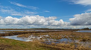
Leegmoor
|
Leegmoor
|
||
| location | Southeast of Papenburg , Emsland district , Lower Saxony | |
| surface | 450 ha | |
| Identifier | NSG WE 136 | |
| WDPA ID | 82082 | |
| Geographical location | 53 ° 0 ' N , 7 ° 33' E | |
|
|
||
| Sea level | from 3 m to 9 m | |
| Setup date | December 31, 2009 | |
| administration | NLWKN | |
The Leegmoor is a nature reserve in the Lower Saxon community of Surwold in the combined community of Nordhümmling in the Emsland district .
The nature reserve with the sign NSG WE 136 is around 450 hectares in size. It is completely part of the approximately 461 hectare FFH area of the same name and the approximately 6,441 hectare EU bird sanctuary “Esterweger Dose”. In the east it borders directly on the nature reserve " Melmmoor / Kuhdammoor ". The area has been a nature reserve since March 19, 1983. The responsible lower nature conservation authority is the district of Emsland.
The nature reserve is located southeast of Papenburg in a moorland south of the coastal canal on the edge of the Esterweger Dose. It is characterized by different moorland habitats. In the south of the nature reserve is a non abgetorftes bog area ( "Timpemoor"). Here you can find raised bog grassland and raised bog heath. The north of the nature reserve is characterized by a peated high moor, which was completely renatured as part of the first part of Lower Saxony's moor protection program (from 1981). After the end of industrial peat extraction in the Leegmoor, the test and development project “Re-wetting of extracted black peat areas in Leegmoor” was launched, with which the rewetting of black peat extraction areas was to be examined for the first time . Until then, only the rewetting of white peat extraction areas had been carried out. An area of around 60 hectares was prepared for the project, which was initially completely free of vegetation after potting. It was rewetted in 1983 and 1984. Until 1996 the development of the area was scientifically monitored.
In the southern part of the moor there is a steel observation tower about 10 meters high , which allows a very good view of the protected area.
The nature reserve is largely surrounded by agricultural land. It is drained from several trenches to the coastal canal.
literature
- Karl-Josef Nick u. a .: Contributions to the rewetting of extracted black peat areas. , Nature Conservation and Landscape Management in Lower Saxony, Issue 29, Lower Saxony State Office for Ecology, 1993.
Web links
- "Leegmoor" nature reserve in the database of the Lower Saxony State Office for Water Management, Coastal and Nature Conservation (NLWKN)
- Leegmoor - revitalized raised bog , leaflet of the Lower Saxony State Office for Water Management, Coastal and Nature Conservation (PDF file, 412 kB)
Individual evidence
- ↑ Leegmoor , profiles of the Natura 2000 areas, Federal Agency for Nature Conservation . Retrieved November 16, 2017.
- ↑ Esterweger Dose , profiles of the Natura 2000 areas, Federal Agency for Nature Conservation. Retrieved November 16, 2017.
- ↑ Articles on the rewetting of extracted black peat areas - results of a test and development project in Leegmoor, Emsland district , Lower Saxony State Agency for Water Management, Coastal and Nature Conservation , Issue 29. Accessed April 7, 2011.
- ↑ BfN-Projekt Leegmoor (PDF; 1.0 MB) , pp. 9–12, Federal Agency for Nature Conservation. Retrieved April 7, 2011.
- ↑ Height estimated from photo and number of steps
- ↑ Lookout tower in Leegmoor , Surwold community. Retrieved November 3, 2017.


