Wesuweer Moor
|
Wesuweer Moor
|
||
| location | Southwest of Haren (Ems) , northwest of Meppen | |
| surface | 409 ha | |
| Identifier | NSG WE 267 | |
| WDPA ID | 389995 | |
| Geographical location | 52 ° 44 ' N , 7 ° 9' E | |
|
|
||
| Sea level | from 14 m to 17 m | |
| Setup date | 06/14/2008 | |
| administration | NLWKN | |
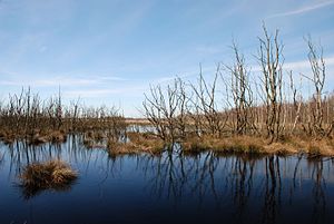
The Wesuweer Moor is a nature reserve in the Lower Saxony towns of Haren (Ems) and Meppen and the municipality of Twist in the Emsland district .
The nature reserve with the registration number NSG WE 267 is 409 hectares in size. It is located northwest of Meppen for the most part in the International Nature Park Bourtanger Moor-Bargerveen and is part of the Bourtanger Moor . In the east, part of the nature reserve borders directly on the A 31 .
The “ Versener Heidesee ” nature reserve connects to the east of the motorway, while the “ Südliches Versener Moor ” nature reserve is to the south .
The reserve provides a high moor area under protection, which is still a large area at the time of industrially under protection abgetorft was. After the peat extraction has ended, the area is to be renatured by rewetting . Parts of the protected area are characterized by wooded areas, moor heath and moor grassland .
The area is drained via ditches to the Wesuwer Schloot, which flows southeast of Wesuwe into the Ems , and partly to the south-north canal .
The area has been a nature reserve since June 14, 2008. The responsible lower nature conservation authority is the district of Emsland.


