Sad
|
Sad
City of Werlte
Coordinates: 52 ° 49 ′ 59 ″ N , 7 ° 39 ′ 59 ″ E
|
||
|---|---|---|
| Height : | 34 m above sea level NHN | |
| Area : | 12.21 km² | |
| Residents : | 880 (December 31, 2013) | |
| Population density : | 72 inhabitants / km² | |
| Incorporation : | 1st January 1973 | |
| Postal code : | 49757 | |
| Area code : | 05951 | |
|
Location of Wehm in Lower Saxony |
||
Wehm is a district of the city of Werlte , Samtgemeinde Werlte , in the Lower Saxony district of Emsland .
origin of the name
Wehm was mentioned around 1000 Widem . The bidem that also occurs is probably a typo . There is witu , wede , later zu wege or woe disfigured. That means wood in general, scrub like trees, also dry wood.
geography
Geographical location
Wehm is located in the northeast of the district about 2 km south of Werlte. The district town of Meppen is about 30 km (as the crow flies) southwest of Wehm. The village is at an altitude of about 35 meters above sea level .
The Mittelradde runs east of the village.
history
Incorporation
With the law on the reorganization of the communities in the areas Leer and Aschendorf-Hümmling on January 1, 1973 , the once independent village of Wehm was incorporated into the municipality of Werlte.
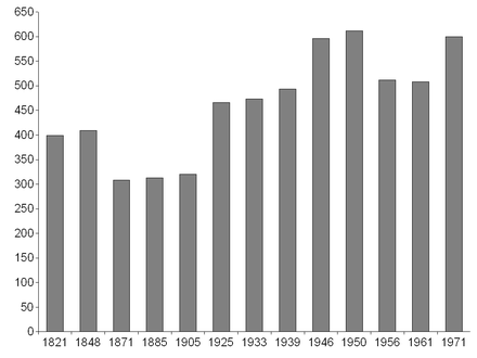
Population development
|
Culture and sights
societies
- Choral society "Frohsinn"
- Rural youth
- Music association "Wehmer Musikanten"
- Nicholas Association
- Shooting club
- SV Oak Wehm
- Tractor friends Wehm
Web links
Individual evidence
- ↑ Geodata Center - Wehm
- ^ Federal Statistical Office (ed.): Historical municipality directory for the Federal Republic of Germany. Name, border and key number changes in municipalities, counties and administrative districts from May 27, 1970 to December 31, 1982 . W. Kohlhammer GmbH, Stuttgart and Mainz 1983, ISBN 3-17-003263-1 , p. 252 .

