Hüven
| coat of arms | Germany map | |
|---|---|---|

|
Coordinates: 52 ° 47 ' N , 7 ° 33' E |
|
| Basic data | ||
| State : | Lower Saxony | |
| County : | Emsland | |
| Joint municipality : | Sögel | |
| Height : | 30 m above sea level NHN | |
| Area : | 15.24 km 2 | |
| Residents: | 542 (Dec. 31, 2019) | |
| Population density : | 36 inhabitants per km 2 | |
| Postal code : | 49751 | |
| Area code : | 05952 | |
| License plate : | Tbsp | |
| Community key : | 03 4 54 023 | |
| Address of the municipal administration: |
Schulstr. 3 49751 Hüven |
|
| Website : | ||
| Mayoress : | Simone Borgmann ( CDU ) | |
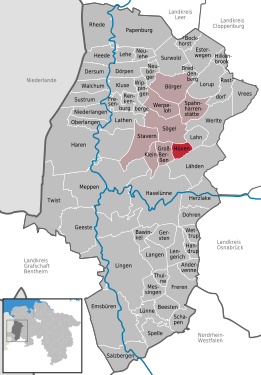
| Location of the community of Hüven in the district of Emsland | ||
Hüven is a municipality in the Emsland district in Lower Saxony . It belongs to the Sögel municipality , which has its administrative headquarters in the Sögel municipality .
The municipality, which extends over 15.24 km², has 558 inhabitants.
geography
Geographical location
Hüven is a few kilometers south of the hilly geest landscape of the Hümmling . It is located between Papenburg in the north-north-west and Haselünne in the south and between the Nordradde in the north-west and the Mittelradde in the south-east.
Neighboring communities
Neighboring communities in the north are the communities Sögel, in the east the communities Lahn in the integrated community Werlte , in the south the community Lähden in the integrated community Herzlake and in the west the communities Groß Berßen .
history
The surrounding area is characterized by numerous megalithic relics of the funnel cup culture, including passage graves (Volbers Hünensteine Sprockhoff No. 842). The community was first mentioned in 919 as Huveni .
politics
Municipal council
The community council from Hüven consists of nine councilors.
mayor
The mayoress Simone Borgmann was elected in September 2016.
Culture and sights
Buildings
- The Hüvener Mühle , built in 1802/1852, is the last remaining combined wind and water mill in Europe.
- Around the place are megalithic graves like Volber's Hünensteine .
literature
- Werner Kaemling: Atlas on the history of Lower Saxony. Gerd J. Holtzmeyer Verlag, Braunschweig 1987, ISBN 3-923722-44-3
- Hermann Abels: The place names of the Emsland, in their linguistic and cultural-historical significance. Ferdinand Schöningh Verlag, Paderborn 1929
- Ernst Förstemann, Hermann Jellinghaus (Hrsg.): Old German name book. Volume II, 1 and 2: Place names , Bonn 1913/1916 (Reprint: Volume II, 2, Hildesheim 1967/1983, ISBN 3-487-01733-4 )


