
Hare (river)

The Hase is a 169.6 km long, eastern and orographically right tributary of the middle Ems in the district of Osnabrück , in the independent city of Osnabrück , in the district of Cloppenburg and in the district of Emsland (all in Lower Saxony ) and in the district of Steinfurt (in North Rhine-Westphalia ) . Its catchment area is 3086 km².
Near Gesmold , in the artificially created Hase-Else bifurcation, the Else branches off from the Hase , whereby part of its water also flows into the river system of the Weser . Much further north, the Hase branches off at Quakenbrück as part of an inland delta that begins there , the Hasedelta , into the Großer Hase and Kleine Hase .
Surname
The Haase spelling was common until the late 19th century . The name of the river has nothing to do with the animal rabbit . The name is derived from a Germanic * haswa (gray), continued, for example, in Anglo-Saxon hasu or Old Icelandic hǫss (gray-brown), also in the popular name Chasuarii (residents of the hare), which is documented in Tacitus 34.1 , among others . Naming a river by a color is not uncommon; compare, for example, the name of the Elbe , which is related to the Latin albus, -a, -um (white).
history
In the 19th century, the course of the river was shortened in the course of straightening. A number of oxbow lakes were built from the upper reaches of Essen / Oldenburg to the mouth in Meppen.
geography
course
Source in the Teutoburg Forest

The hare rises within the district of Osnabrück in the Teutoburg Forest directly on the city limits of Dissen in the southwest and Melle in the northeast. Its source , the Hasequelle , is located within the TERRA.vita nature and geopark in the Puschkental around 3 km south of the Wellingholzhausen district of Mell , between the Steinbrink (approx. 209 m ), an offshoot of the Hankenüll (approx. 307 m ), in the southwest and the Kerßenbrocker Berg (approx. 185 m ) in the east; About 1.5 km north of the Hasequelle (approx. 163 m ) rises the Beutling (approx. 220 m ), on which there is an observation tower.
Source – Hase-Else bifurcation
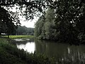
Initially, the hare flows northwest to take in the water from the Black Wave spring (also called Alma spring ), a little more than 1 km below its source . Shortly afterwards it flows around the Kronensee , which is 111 m above sea level and is fed by Hasewater via a canal , after which it is fed by the Rehbach , which gets its water from the Great Deer Spring and the Small Deer Spring , among others .
From now on, the hare runs north, flowing past Wellingholzhausen a little west. A little further north, the artificially created Else branches off from the river striving towards the Ems near the Gesmold district of Melle in the Hase-Else bifurcation , whose water reaches the Weser through the Werre .

Hasequelle in the Teutoburg Forest near the Hankenüll

The hare at Kronensee near Wellingholzhausen

Hare secondary source: Black Wave (Alma Spring)


Hase-Else-Bifurcation – Osnabrück


Shortly below the Hase-Else bifurcation, the Hase crosses under the federal highway 30 , after passing the Bissendorf district of Nemden , turning again to the northwest and passing Ledenburg Castle to the east near the mouth of the Hüppelbruchgraben in the river . It then flows parallel to the Löhne – Rheine railway line , after the confluence of the Wierau , past Wissingen and Lüstringen to the south and, after crossing under the federal motorway 33 , through the core city of Osnabrück . After crossing under the Löhne – Rheine railway line there, the Klöckner Hase ( ⊙ ), which runs north of the railway line, branches off from the Hase flowing south of the railway line (also called Neue Hase here ) at a weir . Above Osnabrück Central Station , the Klöckner Hase ( ⊙ ) joins the Hase; a little below it is the hare weir ( ⊙ ). After flowing through the city center of Osnabrück , the river runs between the city port of Osnabrück to the east, with the Osnabrück branch canal initially running north-west, and the Oldenburg – Osnabrück railway line in the west, north-west to the city limits near Büren .
_Haseuferweg_Kloeckner-Hase_im_Schinkel_in_Osnabr%C3%BCck.jpg)
_Haseuferweg_mit_der_M%C3%BCndung_der_Kloeckner-Hase_in_Osnabr%C3%BCck.jpg)
_Haseuferweg_in_Osnabr%C3%BCck_Richtung_Neumarkt.jpg)

_Pernickelm%C3%BChle_in_Osnabr%C3%BCck.jpg)
_mit_der_Angers-Br%C3%BCcke_in_Osnabr%C3%BCck.jpg)
Osnabrück – Mittelland Canal
After leaving the Osnabrück urban area, the Hase continues between the branch canal in the east and the railway line in the west after the confluence of the Düte past Halen (Steinfurt district) in the west and Hollage (Osnabrück district) in the east, turning to the north. The Hase then crosses under the Mittelland Canal at the Achmer district of Bramsch in Hase düker , in which the Osnabrück branch canal ends around 300 m further east.
_unweit_des_Stichkanals_in_Hollage.jpg)
Mittelland Canal – Bramsche – Bersenbrück


A little further to the northeast, it flows through the core town of Bramsche , located in the district of Osnabrück, between Gehn in the northwest and the Wiehengebirge in the southeast , where it passes the Hasesee , located on the right-hand valley ditch , about 100 m to the west. From then on the river turns north.
Between the Bramscher districts Epe and Pure Kamp the hare running distributed to the Schlippenstraße to the start of the eastern defensive depth Hase (usually only rabbit ; called ⊙ ) and the incipient at the western military channel feeders (on maps partly hare called; ⊙ ) on : The Deep Hase passes the Alfsee reservoir, located between the Ankumer Höhe in the west and the Dammer Mountains in the east near Alfhausen , about 2 km to the east and flows through Rieste . The water of the feeder, which runs east to Hesepe (Bramsche) after its beginning , flows through the reservoir; the first feed line said conduit opens below the Alfsee, now with arresters (i.e. on maps partly Hase ) designated in the rabbit. A few meters after the start of the Tiefen Hase , the Sögelner Mühlenbach ( ⊙ ) branches off from it, which floods around Haus Sögeln to the west and meets the Tief Hase above Rieste . About 170 m after the start of the Tiefen Hase , this takes up the right-hand valley ditch ( ⊙ ), which feeds the Hohe Hase ( ⊙ ) through a bridge ( ⊙ ) beginning about 250 m south of this point next to a bridge on the Schlippenstrasse . This serves to flood the Malgarten monastery (Bramscher district Epe-Malgarten) and the upcoming situation (also known as the Lage Kloster ; municipality of Rieste). The Wulfert Graben, which existed until a few decades ago, can be seen on old maps in the municipality of Rieste . This tributary of the Hohe Hase was mainly used to irrigate meadows. Another branch in the Riester area is the Alte Hase (also called birch), which runs through the Hammer residential area, among other things. The Tief Hase and Hohe Hase unite ( ⊙ ) a little below Rieste- Hülsort and a little northwest of the Lage monastery. Shortly after the run in from the southeast zoom flowing nuns Bach the rabbit takes the water of coming from the Alfsee arrester ( ⊙ on), after which the rabbit (meantime twice abandoned) TERRA.vita Nature Park (final) and leaves Bersenbrueck achieved.
Bersenbrück – Badbergen

In Bersenbrueck, where up to the Hase to its mouth in the EMS through the recreation area Hasetal flows, branches off from the flow of a tidal fence of rabbit channel ( ⊙ ; initially, mill Umflut , Bersenbrücker Wiesbaden channel , field mill Bach , Hase fraction withdrawal or mill rabbit and in the middle and lower part also called old hand ). It was laid out in 1293 to supply the Bersenbrück monastery and the associated mill and runs a little west of the main river. East of Badbergen it flows into the Hase ( ⊙ ). Below the village, the Hase runs through the eastern foothills of the Artland .
Badbergen – Quakenbrück – Löningen – Herzlake


Hasedelta :
Already above Bersenbrück, the water of the Hase has the opportunity to flow over secondary routes, for example over the Alte Hase and the Grother Canal ( ⊙ ) that branches off from it into the Kleine Hase below Quakenbrück . Hasewasser also flows to the right in several places above the former Schützenhof weir into the Wrau . However, the "Hasedelta" is primarily the area below the point where the Hase on the border of the Badbergen community with the town of Quakenbrück near the Quakenbrücker Schützenhof a few meters south of the former Haseüberfall (Schützenhofwehr; ⊙ ) into the Große Hase and the Kleine Bunny divides:
Große Hase :
Near Badbergen, the Wrau ( ⊙ ), which flows east parallel to it, branches off from the Hase and initially takes up the Heller Binnenbach (Möllwiesenbach) and in Quakenbrück to the attack hare ( ⊙ ), which begins a few meters south of the former Hase attack ( ⊙ ) as part of the Großer Hase transfers; the latter forms the main arm of the hare on the right-hand side from the beginning of the hare delta. Until the reunification with the Little Hare , waters essentially flow into this arm from the left, which represent a cross-connection to the Little Hare . After about 1.7 km of flow, the Wrau ( ⊙ ) joins the attack hare. To the northeast of Quakenbrück, the Bünne-Wehdeler Grenzkanal ( ⊙ ) flows into the watercourse, which is also known as the Essen Canal or Neue Hase . A little further north west which happens Large Rabbit food , according to which from the district of Vechta coming Lager Hase ( ⊙ ) opens. Later, the flowing water, henceforth only known as the Große Hase , runs through Löningen , where it receives the Löninger Mühlenbach .
Kleine Hase :
The Kleine Hase ( ⊙ ), which begins at the beginning of the Hasedeltas as a branch on the left side of the hare, flows westwards through Quakenbrück. Derivatives to the right usually flow into the Great Hare . About 2 Little Hare river kilometer below the branching of their Trent bearing channel hits ( ⊙ ) of the old rabbit coming Grother channel west of Quakenbrueck from the left to the Little Rabbit . Further tributaries from the south are the Reitbach , Eggermühlenbach and Kaulkebach . Below Menslage , after the confluence of the Hahler Beeke , the Kleine Hase forms the 16.15 km long Hahnenmoorkanal , which flows north of the Hahlener Moors and the Hahnenmoors , takes in the Renslager Canal from the south and its water after reaching the Emsland district a little west below Herzlake feeds the former Aselage estate into the Große Hase ( ⊙ ). The Kleine Hase and the Hahnenmoorkanal are together 24 km long. If the "Hase Inland Delta" is defined as the area in which the Hase has branched out by itself without human intervention, then the area north of the Hahnenmoorkanal does not belong to the Hase Inland Delta.
Cross connections : In the Hasedelta - between Quakenbrück and Herzlake - there are several cross connections from the small to the large hare ; in particular these are:
The Deichhase ( ⊙ ) flows north-west into downtown Quakenbrück. A few meters southwest of the Quakenbrück outdoor pool, it divides into three arms ( ⊙ ), the left of which leads to the Kleiner Hase . The middle arm, into which the right arm is returned after a short distance, is called the Great Mill Hare ; it flows through the settlement core of the core city first in a westerly, then in a northerly direction. The Große Mühlenhase crosses under the federal highway 68 , flows east past Hengelage and meets ( ⊙ ) west of the Brokhagen-Stau weir on the Essen Canal . Before this man-made hydraulic structure existed (it was built in the last quarter of the 18th century), the Große Mühlenhase continued to flow until Easter. Before the hare regulation began, it absorbed the majority of the water masses of the hare and was therefore the forerunner of the large hare , which flowed past the center of Essen (in the bed of today's Hase camp ). By diverting the Großer Hase to the Raid Hase and the Essen Canal , not only Quakenbrück, but also Essen was protected from flooding.
The Trentlager Canal branches off to the right on the western edge of Quakenbrück at the point ( ⊙ ) from the Kleiner Hase , where it forms the border between the town of Quakenbrück and the municipality of Menslage. The canal approaches the Great Hare in a north-westerly direction. It forms the border between the joint municipality of Artland and the district of Osnabrück on the one hand and the municipality of Essen and the district of Cloppenburg on the other. On its last section, it separates the municipality of Essen from the city of Löningen and meets ( ⊙ ) the Großer Hase on both borders . The Trentlager Canal essentially emerged from the regulation of the former Stumborger Bach .
Another cross connection is the Bühnenbach , which branches off from the Kleine Hase immediately southeast of the center of Menslage ( ⊙ ), flows through Röpke and reaches the Große Hase southwest of gusts ( ⊙ ). Before the construction of the Hahnenmoor Canal , the Bühnenbach represented the lower reaches of the Kleiner Hase , so that at that time the Hasedelta ended at its mouth.

Beginning of the hare delta: on the left the little hare, in the background the attack hare

The Deichhase above the Quakenbrücker Stadtpark
The hare in Löningen
The bunny in a heart sheet
The hare in Meppen, shortly before it merged with the Dortmund-Ems Canal


Herzlake – Meppen
To the west below Herzlake, the Hase flows to the confluence of Südradde and Lager Bach through Haselünne , after which it picks up Lotter Beeke . A little below Haselünne, the Bawinkler Bach flows into the Hase near Hamm and the Mittelradde between Lehrte -Kreyenborg and Dörgen . After passing Bokeloh , it absorbs the water of the Teglinger Bach . Shortly afterwards, the river crosses under the Emsland route when it reaches the core town of Meppen , after which a remnant of the Ems-Hase Canal (Alter Ems Canal) branches off as a short branch canal from the south .
Estuary in Meppen

Somewhat south-southeast of the Emshafen near Meppen city center , the basin of which is located in an arm of the Old Hase , the Hase flows into the Dortmund-Ems Canal and about 600 meters northwest of it into the North Sea tributary Ems , which comes from there from the south ; The river and canal therefore share the flow stretch near the mouth.
Hare-Else bifurcation
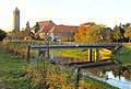
At the Hase-Else bifurcation ( ⊙ ) located near Melle- Gesmold in the border area of the Uhlenberg and Dratum-Ausbergen farmers at 79.8 m above sea level, the river divides into the Hase, which strives towards the Ems in the west, and the Hase that branches off from it and the Water system of the Weser belonging Else to the east, so that each arm on both sides of the Weser-Ems watershed has a different river system as its destination. Around two thirds of the water runs in a mainly north-westerly direction than Hase to Meppen zur Ems, around a third of the water flows as Else in a predominantly eastward direction near Kirchlengern into the Werre , which also flows eastward into the Weser .
The Hase-Else bifurcation did not arise naturally, but rather the result of a dispute over water rights. First, a ditch was dug in the 16th century in order to be able to operate the mill at Gesmold Castle better. Only later did the name Else appear for the artificially diverted water and led to a kind of bifurcation euphoria in the 19th and 20th centuries, because it was believed to be able to refer to a unique natural phenomenon.
Catchment area and tributaries
The catchment area of the Hase is 3086 km². Their tributaries include, with orographic allocation (l = left-hand side, r = right-hand side) and the point of discharge, considered downstream:
- l; Rehbach (above Wellingholzhausen )
- l; Königsbach (between Wellingholzhausen and Gesmold )
- r; Alte Hase ( Schnatgraben ) (between Nemden and Wissingen )
- r; Flöthegraben (between Nemden and Wissingen)
- r; Wierau (above Wissingen)
- l; Rosenmühlenbach (near Lüstringen )
- l; Sandforter Bach (in Osnabrück )
- r; Belmer Bach (in Osnabrück- Fledder )
- r; Nice (in Osnabrück at the harbor)
- l; Eversburger Landwehrgraben (on the western border of Osnabrück; coming from the Rubbenbruchsee )
- l; Düte (near Halen )
- l; Ueffelner Aue (in Alfhausen via the Alfsee drain)
- l; Heeker Mühlenbach (in Alfhausen via the Alfsee drain)
- r; Nonnenbach (below Rieste )
- r; Bünne-Wehdeler Grenzkanal (into the Große Hase ; border of the districts of Osnabrück and Cloppenburg)
- r; Lager Hase (in the Große Hase ; below Essen )
- l; Bühnenbach (in the Große Hase ; above Löningen )
- r; Löninger Mühlenbach (in the Große Hase ; in Löningen)
- l; Reitbach (in the Kleine Hase ; above Menslage )
- l; Eggermühlenbach (in the Kleine Hase ; above Menslage)
- r; Südradde (below Herzlake )
- l; Camp Bach (above Haselünne )
- l; Lotter Beeke (below Haselünne)
- l; Bawinkler Bach (near Bückelte )
- r; Mittelradde (between Lehrte and Dörgen )
- r; Dörgener Beeke (between Lehrte and Dörgen)
- l; Kamphausgraben (above Bokeloh )
- l; Teglinger Bach (below Bokeloh)
Localities
The localities on the Hase include:
- Melle - Wellingholzhausen - nearby Hasequelle
- Melle- Gesmold - Hase-Else bifurcation
- Osnabrück
- Bramsche - Distribution in Depth Hase and Alfsee- feeders / arrester ; some of which branch out further, u. a. in the high hare
- Rieste - flowed through u. a. of rivers / tributaries of the Tief Hase and Hohe Hase
- Alfhausen
- Bersenbrück - branch of the Hase Canal
- Gehrde
- Badbergen - mouth of the Hase Canal; Branch of the Wrau
- Quakenbrück - division u. a. in Big Hare and Little Hare at the Hase attack (Schützenhofwehr)
- Menslage - channeled as a little rabbit ; Mouth of the Wrau
- Essen , Löningen - channeled as a big rabbit
- Herzlake - to the east above it is the convergence of the Großer Hase and Kleiner Hase
- Haselünne - tributary of the Südradde
- Haselünne- Dörgen - tributary of the Mittelradde
- Haselünne- Lehrte
- Bokeloh
- Meppen - confluence with the Dortmund-Ems Canal / Ems
Floods and aquatic ecology
The slope of the Hase is 72 cm / km between the bifurcation and Bersenbrück. On the further stretch of the river to Quakenbrück, it decreases to 30 cm / km and then to 14 cm / km up to the confluence with the Ems (near Meppen). Due to the small difference in altitude and the associated low flow speed of the water in the middle and lower reaches of the Hase, natural damming effects occurred again and again before the construction of the Alfsee (especially during the time when the Hahnenmoorkanal was still used to bypass the bottleneck below Löningen did not exist), so that in the past the Hare and its tributaries often overflowed their banks. For centuries people have come to terms with this. A farmer from the Haselünne area describes the situation with the words:
- “Floods were part of everyday life. Our ancestors also lived there. These old Hasedörfer like Lahre, Huden, there they are intentionally drawn in to use this flood as fertilizer. These were very popular farms here on the Hase or on the Ems. "
The flood often stopped at the edge of the village and then slowly withdrew. But sometimes the villages were also flooded. The floods also offered good protection from robbing and plundering hordes. At the same time, the river bed was naturally cleaned, which today has to be done through costly maintenance measures. After the hare had been dyed, the farmers created artificial irrigation systems, the trickle meadows, so that the hare's natural fertilizer could continue to grow on their land. In the last few decades, however, fertilizer has changed from a coveted raw material to an abundance of problematic substances, and any flooding of agricultural land has become a disadvantage for farmers, so that attempts have been made to avoid it through water management measures, among other things. The last major flooding in the Haseaue took place in 1981 before the Alfsee came into operation.

As early as 1683 the first weir was built at today's Schützenhof in Quakenbrück, the Hase attack , with the help of which the Große Hase, which had previously flowed through the town center of Quakenbrück, was diverted around the city. Since then, a variety of measures have been taken to protect the people and their property at the Hase from flooding. In the 1950s and 1960s in particular, the river was diked and straightened, and river loops were cut off to allow the water to drain more quickly. In parts, the hare resembles a canal, even a “Grand Canyon” by increasing the flow speed and deepening the river bed. Larger water masses were diverted to fields at certain times by means of gates in order to supply them with minerals; "Rieselwiesen" formed.
To major flooding prevention, originated from 1972, the 2.2 square kilometers large Alfsee between Rieste and Alfhausen that up to 13 million cubic meters can accommodate Hase water; In addition, a reserve basin can hold 8 million m³ of water. The reserve basin is located in the reserve basin Alfhausen-Rieste nature reserve .

As part of the "International Management Plan according to Article 13 of the Water Framework Directive [of the EU ] for the Ems River Basin 2010–2015", the ecological quality of the Hase and its floodplains was consistently rated as at least "unsatisfactory". A survey in 2004 had already criticized: “Due to straightening, deepening, widening, walling, damming and the removal of the natural wood on the banks, most of the bodies of water in the study area have largely lost their function as natural habitats. Only about 10% are 'slightly' or 'moderately changed' (GKL II or III), but almost half of the bodies of water are classified in structural quality classes VI and VII ('very strongly' or 'completely changed' water sections). “In the past few years, some hydraulic engineering measures from the past have been reversed in order to mitigate the negative ecological consequences of the interventions. For example, the hare attack was converted into a sole slide , which allows fish and other aquatic organisms to migrate up and down the river in the attack hare, provided that it is possible in practice to prevent the hare from being caught by fish at any point flows faster than 1.5 m per second.
The waters flowing from the south into the Kleine Hase and the Hahnenmoorkanal are grouped together in the FFH area Bächen in Artland .
use
shipping
The hare never played a special role in shipping. Only the lower course is navigable for around 50 kilometers. So-called Emspünten, a type of ship that was able to cope with most shallows with its flat bottom and was therefore still used on shallow rivers until the 1920s, operated. The barges were usually made of oak and equipped with a sail and usually had to be towed on the hare .
The last 1.6 km of the Hase (Ha) in Meppen are designated as a federal waterway , of which almost 600 m of the estuary run together with the Dortmund-Ems Canal . The Meppen Waterways and Shipping Office is responsible for this .

water sports
The hare is widely used by water sports enthusiasts, especially canoeists , rowers and dinghy drivers. At the Alfsee , which is fed by the water of the Hase, there is a water ski facility and a boat harbor with a slipway for sailing ships. At Quakenbrück , canoe polo is played on the rabbit .
Fishing
According to the Lower Saxony Fisheries Act of 1978, the hare is divided into three fishing districts, namely:
- Hase I (from the Bietendorfer mill near Wellingholzhausen to the intersection with the Mittelland Canal near Bramsche)
- Hase II (from the intersection with the Mittelland Canal to the Brokhagen dam below Quakenbrück)
- Hase III (from Brokhagen-Stau to the confluence with the Dortmund-Ems Canal)
The European Water Framework Directive obliges all member states to improve the ecological status of their rivers by 2015 and thereby achieve the "restoration of ecological continuity" for fish. The hare is already livelier than it was before the renaturation measures began. Even in the Osnabrück urban area, despite massive interventions in the past, there are still around 30 species of fish in the hare, most of the fish being stocking fish that anglers release. You can fish along almost the entire hare with a fishing license or guest card .
Long-distance cycle path
The Hase-Ems-Tour long-distance cycle route runs from the source to the mouth of the Hase. Cyclists who complete the tour accompany the hare along its bank in sections, in other sections they move away from it.
- Trivia
As a child, Erich Maria Remarque had parts of this path to school. As the author of the novel Nothing New in the West , he used this route for the soldier Paul Bäumer on home leave.
literature
- Heinrich Böning: Along the hare. From Osnabrück via Quakenbrück to Meppen. Sutton-Verlag, 2004. ISBN 3-89702-750-X .
- Contributions to the limnology of the upper and middle rabbits. In: Osnabrücker Naturwissenschaftliche Mitteilungen. 4.1976, ISSN 0340-4781
- Werner Dobelmann : The hare shaped the north of Osnabrück. Geographical and historical aspects , in: Am heimatlichen Herd - Heimatblatt 37 (1986), No. 1 (March 1986), pp. 1–4 (posthumously)
- Werner Dobelmann : Siedlungen an der Hase , in: Am heimatlichen Herd - Heimatblatt 38 (1987), No. 3 (July 1987), pp. 10-12 (posthumously)
Individual evidence
- ↑ a b c German Hydrological Yearbook Weser-Ems 2008 Lower Saxony State Agency for Water Management, Coastal Protection and Nature Conservation, accessed on January 22, 2016 (PDF, German, 6184 kB).
- ↑ a b The bifurcation in Gesmold (Hase-Else-Bifurkation), on bifurkation.de
- ↑ According to Dutch etymologists, the animal name rabbit is also derived from this Indo-European word stem; the animal, like the river, was named after its gray color. Source: www.etymologiebank.nl Digital Etymology of the NL. Language, prof. Dr. N. van der Sijs ca, meeting word: Haas (hare)
- ↑ Minden Waterways and Shipping Office: culverts and passages , on wsa-minden.de
- ↑ Water body data sheet: 02064 Hahnenmoorkanal , Lower Saxony State Agency for Water Management, Coastal and Nature Conservation (NLWKN), November 2012 (PDF; 87.42 kB)
- ↑ show District 13 in: . Classification of watercourses second order in shop districts with the actors Representative for the term of office from 01.01.2003-31.12.2007 ( Memento of 24 December 2014 Internet Archive ), the entertainment Association 97 Medium hare, on uhv97.de, P. 7 (PDF; 27.41 kB)
- ↑ a b c Wilhelm Müller-Wille: Floor sculpture and natural spaces in Westphalia . 1966. p. 266 (PDF; 4.89 MB)
- ↑ Map services of the Federal Agency for Nature Conservation ( information )
- ↑ Stefan Kröger: Das Osnabrück-Lexikon , 2004, p. 27
- ↑ Horst Neumann: Hydrological data on the hare and its catchment area with 4 tables . Osnabrück natural science communications . 1976, p. 11 (PDF; 8.77 MB)
- ↑ Ita Niehaus: The beaver followed the excavator. The revitalization of the Haseauen in Emsland . Germany radio . March 10, 2009
- ↑ Artland Gymnasium: Quakenbrück Water and Nature Trail , on bio.artland-gym.de
- ↑ Quakenbrück: Sohl slide instead of weir at the Schützenhof , in: Neue Osnabrücker Zeitung , from April 18, 2011
- ^ Matthias Ellmann: The hare on the way to the Grand Canyon Münsterländische Tageszeitung . December 13, 2012 (PDF; 1.45 MB)
- ^ Heinrich Böning: Along the hare. From Osnabrück via Quakenbrück to Meppen , p. 8 (see section Literature )
- ↑ Lower Saxony State Office for Water Management, Coastal Protection and Nature Conservation (NLWKN) Meppen office: International management plan in accordance with Article 13 of the Water Framework Directive for the Ems river basin district 2010-2015 ( Memento of the original from October 22, 2014 in the Internet Archive ) Info: The archive link was automatically inserted and not yet checked. Please check the original and archive link according to the instructions and then remove this notice. . 2009. p. 229 (PDF; 15.73 MB)
- ↑ Lower Saxony State Agency for Water Management, Coastal Protection and Nature Conservation (NLWKN): Water body data sheets for waters with priority 4: WK02013 Hase - Große Hase . September 2012
- ↑ Bezirksregierung Weser-Ems / NLWKN: Inventory of the implementation of the EU Water Framework Directive. Surface waters - Hase processing area . 2004. p. 9 (PDF; 327.37 kB)
- ↑ First test run - Hare attack in Quakenbrück finished at the end of September . Neue Osnabrücker Zeitung , September 5, 2013, on noz.de
- ↑ Nature and Geopark terra.vita: FFH area “ Bächen im Artland” ( Memento of the original from March 5, 2016 in the Internet Archive ) Info: The archive link has been inserted automatically and has not yet been checked. Please check the original and archive link according to the instructions and then remove this notice. (PDF; 2.35 MB)
- ↑ The course of the hare from the source to the mouth , on Umweltbildung.uni-osnabrueck.de
- ^ Association for the Promotion of Historical Ems Shipping e. V. ( Memento of the original from January 1, 2009 in the Internet Archive ) Info: The archive link was inserted automatically and has not yet been checked. Please check the original and archive link according to the instructions and then remove this notice. , on emssaga.de
- ↑ Lengths (in km) of the main shipping lanes (main routes and certain secondary routes) of the federal inland waterways ( memento of the original from January 21, 2016 in the Internet Archive ) Info: The archive link was inserted automatically and has not yet been checked. Please check the original and archive link according to the instructions and then remove this notice. , Federal Waterways and Shipping Administration, on wsv.de.
- ↑ Directory E, Ser. Nos. 19 and 7 as well as directory F of the chronicle ( memento of the original from July 22, 2016 in the Internet Archive ) Info: The archive link was inserted automatically and has not yet been checked. Please check the original and archive link according to the instructions and then remove this notice. , Federal Waterways and Shipping Administration, on wsv.de.
- ↑ Ludwig Ellerbrake / Jochen Kruse: Hase . German Rowing Association , 2012, on gewaesser.rudern.de
- ↑ Appendix 2 Nds. FischG - (on Section 18 Paragraph 1) ( Memento of October 21, 2012 in the Internet Archive ) (Annex 2 to the Lower Saxony Fisheries Act on Section 18 Paragraph 1), p. 25 ff, from pachtverein.de (PDF; 155.42 kB)
- ↑ Project Lebendige Hase , on lebige-hase.de
- ↑ Christoph Beyer: Osnabrücker Land - naturally diverse, world history and forest stories. Gmeiner Verlag, 2015, p. 19
Web links
- Project Lebendige Hase , on Lebendige-hase.de
- Education for sustainable development: Rediscovering the rabbit (environmental education at the University of Osnabrück), at Umweltbildung.uni-osnabrueck.de
- Association for the revitalization of Haseauen e. V. , on haseauenverein.de
- Hase-Else bifurcation at Melle-Gesmold , at bifurkation.de
- Assessment of the implementation of the EU Water Framework Directive - processing area Hase (PDF; 327.3 kB), on wrrl-kommunal.de
- Flood - hazard map of the district of Osnabrück, on landkreis-osnabrueck.de
- Osnabrück: Still many dead fish in the rabbit on July 28, 2020 on ndr.de, accessed on July 28, 2020