
Camp bunny
| Camp bunny | ||
 Bank of the Hase camp near Essen / Oldenburg |
||
| Data | ||
| location | In Lower Saxony (districts of Vechta and Cloppenburg ) | |
| River system | Ems | |
| Drain over | Hase → Ems → North Sea | |
| source | Confluence of Dinklager Mühlenbach and Aue 52 ° 42 ′ 3 ″ N , 8 ° 4 ′ 13 ″ E |
|
| muzzle | near Essen / Oldenburg in the Große Hase Coordinates: 52 ° 43 ′ 6 " N , 7 ° 54 ′ 33" E 52 ° 43 ′ 6 " N , 7 ° 54 ′ 33" E
|
|
| Small towns | Dinklage | |
| Communities | Essen / Oldenburg | |
The Lager Hase is a 12.2 km long river, which arises on the border between the city of Dinklage and the municipality of Essen / Oldenburg from the confluence of the Dinklager Mühlenbach and the floodplain and 2 km west of the center of Essen with the Essen Canal to the Große Hase combined to give the waters for part of Hase - inland Delta is. Occasionally the 3.2 km long section of the Dinklager Mühlenbach between the confluence of the Hopener Mühlenbach and the floodplain of the Lager Hase is included, which is 15.4 km long according to this definition.
course
From the confluence of the Dinklager Mühlenbach and the Aue, the Lager Hase flows westwards and forms the border between the districts of Vechta and Cloppenburg . After a kilometer, the river passes the Lage Gut , from which it owes its name. The next larger body of water flowing 2.7 km downstream is the Fladder Canal , today the continuation of the Vechta Moorbach under a different name. On their way through the area of the municipality of Essen, after 700 m the Calhorner Mühlenbach and 3 km away from it the Blocksmühlenbach flow from the right into the camp Hase , before this 3 km west touches the center of Essen in the south and after another 2 km as a large one Bunny continues to flow.
Naming
Despite its name, the Hase camp does not form part of the Hase Inland Delta today , as it does not absorb water from the upper reaches of the Hase. Carl Heinrich Nieberding points out, however, that a watercourse he called the “Vechtaer Bach” had flowed to Osteressen before 1840. As can be seen from his further description, Nieberding means by Vechtaer Bach a watercourse that was not interrupted at the time, whose upper course was the Vechta Moorbach , whose middle course was the floodplain and whose lower course was the camp Hase . Until the last quarter of the 18th century, this so-called Vechta Bach met the "Osnabrücksche Haase" at Easter, but it was moved westward before 1800 and via a "new Haase Canal" (i.e. the Neue Hase or the Essen Canal ) was directed. Accordingly, at least the section of the Hase camp below Osteressen would have previously belonged to the Hase inland delta.
Attractions
A section of the Hase-Ems-Tour long-distance cycle path (namely the section south of the Essen town center immediately west of Bundesstraße 68 ) runs 1.1 km along the Hase camp, and one of the works of art that were displayed along the route is in this area, namely the sandstone sculpture “in the river” by Regine Meyer zu Strohe.
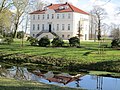
Good location with moat near the Hase camp

Sculpture “in the river” on the banks of the Hase camp near Essen


Development status and water quality
The Lager Hase has been straightened, expanded and diked along the entire length of 12 km from the confluence of the Aue and Dinklager Mühlenbach to its confluence with the Große Hase near Essen. In the urban area of Essen, the dike serves to protect the village against flooding. Here, the dike was laid back in parts to enable the creation of a flood retention basin and succession areas. Due to the expansion and the lack of wood on the banks, the river bed dynamics of the Hase camp has been severely damaged. Only in sections in which the bank reinforcement made of stakes and wicker fences is slowly deteriorating was it rated better. Due to the dyke, the floodplain, which is mainly used for agriculture, is cut off from the river.
The ecological condition of Lager Hase was rated “unsatisfactory” in 2009 by the Lower Saxony State Agency for Water Management, Coastal and Nature Conservation (NLWKN).
Traffic routes crossing the river
The federal road 68 from Essen to Quakenbrück and the country roads from Bevern to Quakenbrück and from Addrup or Lüsche to Wulfenau lead via the Hase camps . The Oldenburg – Osnabrück railway also crosses the Hase camp.
Individual evidence
- ↑ z. B. Geoview: Camp Bunny
- ^ Carl Heinrich Nieberding: History of the former Niederstift Munster and the adjacent counties . 1st volume. CH Fauvel, Vechta 1840, p. 9 ( online )
- ↑ Lower Saxony State Office for Water Management and Coastal Protection (NLWKN), Cloppenburg office: Regional structural quality report of the NLWK Cloppenburg office, section Lager Hase / Dinklager Mühlenbach (GKZ 364) ( Memento of the original from October 16, 2014 in the Internet Archive ) Info: The archive link was inserted automatically and not yet tested. Please check the original and archive link according to the instructions and then remove this notice. . 2000, p. 34
- ↑ Lower Saxony State Office for Water Management, Coastal Protection and Nature Conservation (NLWKN) Meppen office: International management plan in accordance with Article 13 of the Water Framework Directive for the Ems river basin district 2010-2015 ( Memento of the original from October 22, 2014 in the Internet Archive ) Info: The archive link was automatically inserted and not yet checked. Please check the original and archive link according to the instructions and then remove this notice. . 2009. p. 230