
Hopener Mühlenbach
| Hopener Mühlenbach | ||
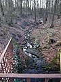
 The lowest pond in the Lohner city park through which the Hopener Mühlenbach flows |
||
| Data | ||
| location | In Lower Saxony ( Vechta district ) | |
| River system | Ems | |
| Drain over | Dinklager Mühlenbach → Lager Hase → Hase → Ems → North Sea | |
| source | in the area of the city of Lohne 52 ° 39 ′ 39 ″ N , 8 ° 15 ′ 9 ″ E |
|
| muzzle | northwest of Dinklage confluence with the Dinklager Mühlenbach Coordinates: 52 ° 40 ′ 30 " N , 8 ° 5 ′ 14" E 52 ° 40 ′ 30 " N , 8 ° 5 ′ 14" E
|
|
| Small towns | Pay , Dinklage | |
The Hopener Mühlenbach is an approx. 13 km long body of water that rises at the foothills of the Dammer Mountains in the area of the town of Lohne in the Lower Saxony district of Vechta , flows through the settlement core of the town of Lohne in a westerly direction and in the northwest of the town of Dinklage into the Dinklager Mühlenbach flows out. The catchment area of the Hopener Mühlenbach and its tributaries covers 33 km².
course
In a gorge up to eight meters deep, southeast of the town center of Lohne, several springs arise in a wood that led to the early settlement of Lohne in the 10th century. The spring water reaches the Lohner city park after a few meters. Several retention basins have been created here. At the edge of the city park, the water of the Mühlenbach drives an undershot water mill, the pastor's mill, built in 1859. Today it is used as an exhibition space by the "Kunstverein Wassermühle Lohne".
Flowing further west, the brook reaches the Hopener Burgwald and the Wasserburg Hopen , with sections piped in between . Beyond the Delmenhorst – Hesepe railway operated by the Nordwestbahn , the Hopener Mühlenbach first crosses a forest and meadow area and then the Runenbrock recreational area. Several fish ponds have been created in this section south of the stream. The western branch of the Brückenradweg , a long-distance cycle path that connects Bremen with Osnabrück , runs along the section between the railway line and the Südring, the new Lohnes Südtangente .
After crossing under the southern ring, the Hopener Mühlenbach reaches Brockdorf , which it crosses in a west-north-westerly direction. Many businesses have settled in this area, which was originally characterized by agriculture. After changing to the northern side of the motorway feeder, the L 845, the Hopener Mühlenbach reaches the federal motorway 1 , west of which it changes to the area of the city of Dinklage. Several flood protection areas have been designated in Dinklage.
The stream essentially limits the settlement core of the city of Dinklage to the north, maintaining its west-northwest flow direction. It runs on a section northeast of the city center parallel to the new Dinklage bypass, the L 845. Since 1967 and 1973, the Hopener Mühlenbach has been feeding two fish ponds in the “Wild Pool” area, which are managed by the Dinklage fishing association. A new residential area, “Mühlenbachtal”, is being built west of Quakenbrücker Straße, immediately south of the lowest section of the Hopener Mühlenbach . 5.9 km downstream of the motorway it flows into the Dinklager Mühlenbach . The surface water of the Hopener Mühlenbach is fed to the North Sea via the camps Hase , the Hase and the Ems .
Headwaters of the Hopener Mühlenbach stream

Pastoratsmühle (water mill) in the Lohner city park

Warehouse of the plastics company RPC Bramlage on the Dinklager section of the stream


ecology

The Hopener Mühlenbach belongs to the area in the water system of the Hase, the condition of which was rated negatively in 2004 by the then Weser-Ems district government and the Lower Saxony State Agency for Water Management, Coastal and Nature Conservation (NLWKN) (in 2009 the creek was given a "moderate ecological condition") certified). In order to enhance the ecological quality of the Hopener Mühlenbach and its floodplains and thus comply with the water framework directive of the European Union from the year 2000, the “Integrated Rural Development Concept (ILEK) Vechta Middle / South” 2006 included the project “Hopener Mühlenbach and tributaries”. recorded. Through this, a revitalization of the stream, the creation of biological continuity and the creation of near-natural retention areas with permanent grassland in the floodplain should be achieved and the water quality improved. The excessively deep receiving water in the Burgwald Hopen should be reduced, a nature-friendly groundwater level should be restored and biotopes should be networked. A nature-friendly local recreation was aimed for.
It is controversial whether the achievement of the stated goals was impaired by the expansion of industrial areas in Lohne and Dinklage as well as by the construction of bypasses in both cities. The administration of the city of Lohne justified the clearance of areas immediately south of the Hopener Mühlenbach for the construction of commercial buildings with the fact that "the southern area [...] is characterized by a significantly elevated position". “A flood area stipulated by law - or even a natural flood area - is not recorded here. In this respect, the city is not assuming a valuable and mandatory protection of alluvial areas in the present plan. "
Individual evidence
- ^ Lower Saxony Ministry for Climate, Energy and Environmental Protection: Area directory for the Lower Saxony hydrographic map . P. 16
- ↑ Regional management in the district of Vechta: Discovery tour to almost forgotten sources on August 11, 2013
- ^ Working group Mühlenstrasse of the Mühlenvereinigung Niedersachsen-Bremen eV: Wassermühle Pastoratsmühle Lohne
- ^ Vechta district: Floodplain of the Hopener Mühlenbach
- ↑ Fischereiverein Dinklage eV: Chronicle
- ↑ City of Dinklage: Mühlenbachtal residential area ( Memento of the original from September 23, 2015 in the Internet Archive ) Info: The archive link was inserted automatically and has not yet been checked. Please check the original and archive link according to the instructions and then remove this notice.
- ↑ Bezirksregierung Weser-Ems / NLWKN: Inventory of the implementation of the EU Water Framework Directive. Surface waters - Hase processing area - . 2004. p. 9
- ↑ Lower Saxony State Office for Water Management, Coastal Protection and Nature Conservation (NLWKN) Meppen office: International management plan in accordance with Article 13 of the Water Framework Directive for the Ems river basin district 2010-2015 ( Memento of the original from October 22, 2014 in the Internet Archive ) Info: The archive link was automatically inserted and not yet checked. Please check the original and archive link according to the instructions and then remove this notice. . 2009, p. 189
- ↑ GfL Planungs- und Ingenieurgesellschaft GmbH: Integrated rural development concept (ILEK) Vechta Mitte / Süd ( Memento of the original from November 25, 2011 in the Internet Archive ) Info: The archive link was automatically inserted and not yet checked. Please check the original and archive link according to the instructions and then remove this notice. . December 18, 2006, p. 122
- ^ City of Lohne: Opinion on the draft of the 62nd amendment to the zoning plan and the development plan no. 134 "Brockdorf - north of Langweger Straße" . Submission for the meeting of the Construction, Transport, Planning and Environment Committee on October 14, 2010