
Bridge cycle path
| Bridge cycle path | |||||||||||||||||||||||||||||||||||||||||||||||||||||||||||||||||||||||||||||||||
|---|---|---|---|---|---|---|---|---|---|---|---|---|---|---|---|---|---|---|---|---|---|---|---|---|---|---|---|---|---|---|---|---|---|---|---|---|---|---|---|---|---|---|---|---|---|---|---|---|---|---|---|---|---|---|---|---|---|---|---|---|---|---|---|---|---|---|---|---|---|---|---|---|---|---|---|---|---|---|---|---|---|

|
|||||||||||||||||||||||||||||||||||||||||||||||||||||||||||||||||||||||||||||||||
| overall length | 314 km | ||||||||||||||||||||||||||||||||||||||||||||||||||||||||||||||||||||||||||||||||
| location |
|
||||||||||||||||||||||||||||||||||||||||||||||||||||||||||||||||||||||||||||||||
| map | |||||||||||||||||||||||||||||||||||||||||||||||||||||||||||||||||||||||||||||||||
| Map section | |||||||||||||||||||||||||||||||||||||||||||||||||||||||||||||||||||||||||||||||||
| Flooring | mostly paved or paved; few sections on unpaved forest trails | ||||||||||||||||||||||||||||||||||||||||||||||||||||||||||||||||||||||||||||||||
| Height difference | 571 m; lowest point: 1 m; highest point: 156 m |
||||||||||||||||||||||||||||||||||||||||||||||||||||||||||||||||||||||||||||||||
| difficulty | low | ||||||||||||||||||||||||||||||||||||||||||||||||||||||||||||||||||||||||||||||||
| Website URL | brueckenradweg.de | ||||||||||||||||||||||||||||||||||||||||||||||||||||||||||||||||||||||||||||||||
|
Route
|
|||||||||||||||||||||||||||||||||||||||||||||||||||||||||||||||||||||||||||||||||
The bridge cycle path is a long-distance cycle path of around 314 kilometers in west-northwestern Lower Saxony and Bremen , which connects the Hanseatic city of Bremen and the former Hanseatic city of Osnabrück on two largely parallel routes. This way, this path builds a bridge between the two cities, but its name also stands for the many individual bridges that have to be crossed in the course of the two partial routes.
The 149-kilometer east route runs through Bassum , Twistringen , Barnstorf and Diepholz . The 165-kilometer west route touches Harpstedt , Goldenstedt , Vechta , Lohne , Steinfeld and Damme .
Scenic highlights of the largely flat stretch are the Mittelland Canal , the Dümmer Nature Park , a section of the Hunte , the Wildeshauser Geest Nature Park and the city of Bremen. In the rather hilly southern part, the forests of the Dammer Mountains , the Museum of the Varus Battle in Kalkriese , the nature and geopark TERRA.vita and Osnabrück , the city of the Peace of Westphalia, beckon .
The sign symbol shows a stylized cyclist crossing a bridge arch.
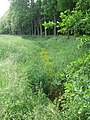
Lot along the Hopener Mühlenbach in Lohne

At the Great Sierhauser Schanze near Damme


See also
literature
- Bridge cycle path Osnabrück-Bremen: from the Peace City to the Weser metropolis, Verlag Esterbauer, Rodingersdorf 2011, ISBN 978-3-85000-303-2
Web links
- BicycleRoutes & Tours: Bridge cycle path , with map, GPS download, elevation profile, sights and accommodations
Individual evidence
- ↑ a b bridge cycle path. Retrieved June 3, 2020 . , on osnabruecker-land.de
- ↑ Bridge cycle path signs. Retrieved May 26, 2010 .