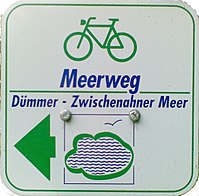
Sea way
| Sea way | |||||||||||||||||||||||||||||||||||||||||||||||||||||||||
|---|---|---|---|---|---|---|---|---|---|---|---|---|---|---|---|---|---|---|---|---|---|---|---|---|---|---|---|---|---|---|---|---|---|---|---|---|---|---|---|---|---|---|---|---|---|---|---|---|---|---|---|---|---|---|---|---|---|

|
|||||||||||||||||||||||||||||||||||||||||||||||||||||||||
| overall length | 288 km | ||||||||||||||||||||||||||||||||||||||||||||||||||||||||
| location |
|
||||||||||||||||||||||||||||||||||||||||||||||||||||||||
| Starting point |
Neustadt am Rübenberge 52 ° 30 ′ 11 ″ N , 9 ° 27 ′ 26 ″ E |
||||||||||||||||||||||||||||||||||||||||||||||||||||||||
| Target point |
Wilhelmshaven 53 ° 31 ′ 19 ″ N , 8 ° 6 ′ 27 ″ E |
||||||||||||||||||||||||||||||||||||||||||||||||||||||||
| difficulty | light | ||||||||||||||||||||||||||||||||||||||||||||||||||||||||
| Traffic volume | low | ||||||||||||||||||||||||||||||||||||||||||||||||||||||||
| Website URL | nordwestreisemagazin.de | ||||||||||||||||||||||||||||||||||||||||||||||||||||||||
|
Route
|
|||||||||||||||||||||||||||||||||||||||||||||||||||||||||
The Meerweg is a 288 km long cycle path from the Steinhuder Meer to the Jade Bay in Wilhelmshaven . It thus connects the three Lower Saxon "seas" Steinhuder Meer, Dümmer and Zwischenahner Meer with the North Sea . The route is divided into five (day) stages.
- 1st stage: Steinhuder Meer Nature Park to the Great Moor
- 3rd stage: Diepholzer Moor - Wildeshauser Geest Nature Park
- 4th stage: Oldenburg - Zwischenahner Meer
- 5th stage: Ammerland - Wilhelmshaven
The route is well signposted in both directions and has little physical fitness demands.
See also
Web links
Wikivoyage: Sea route - travel guide
- Meerweg in the ADFC tour portal ( Memento from March 4, 2016 in the Internet Archive )
- Meerweg on nordwestreisemagazin.de
literature
- Meerweg cycle route map, 1: 50,000, Publicpress-Verlag. ISBN 978-3-89920-265-6
- City of Oldenburg (Oldb.) And concept center verlag gmbh [Hrsg.]: Map set Meerweg. Oldenburg 2007. ISBN 3-934606-24-5 .
Individual evidence
- ↑ a b Meerweg ( Memento from March 4, 2016 in the Internet Archive ) on www.adfc-tourenportal.de. Retrieved December 30, 2017.