
Lerwick
|
Lerwick Scottish Gaelic Liùrabhaig |
|||
|---|---|---|---|
 |
|||
| Coordinates | 60 ° 9 ′ N , 1 ° 9 ′ W | ||
|
|||
| Residents | 6958 2011 census | ||
| surface | 12.783 km² (4.94 mi² ) | ||
| Population density: | 544 inhabitants per km² | ||
| administration | |||
| Post town | SHETLAND | ||
| ZIP code section | ZE1 | ||
| prefix | 01595 | ||
| Part of the country | Scotland | ||
| Council area | Shetland | ||
| British Parliament | Orkney and Shetland | ||
| Scottish Parliament | Shetland | ||

The 6958 inhabitants, Lerwick (pronounced / ləːwɪk / or / lər (w) ɪk /) is the largest city and county seat of about Scotland belonging Shetland Islands .
history
Lerwick was founded in the 17th century. During this time its port served as a port of call for Dutch herring fishermen . In 1701 the Civil Parish Lerwick was separated from the Civil parish Tingwall and in 1708 Scalloway (still part of Tingwall) was the capital of the Shetland Islands. In 1891, due to the Local Government (Scotland) Act 1889, the Civil parish Lerwick was expanded to include Burra (islands in the southwest), Gulberwick and Quarff to the south and thus reached its current area of 32.2 km². However, since the Local Government (Scotland) Act 1929 , the civil parishes in Scotland no longer have an administrative function. The current community council area of Lerwick has a much smaller surface area, does not include Burra, Gulberwick and Quarff, but essentially Lerwick in its original Parish delimitation. The population of 6959 at the 2011 census refers to the smaller area and does not include the entire Parish. The total Parish had a population of 8,607, including Gulberwick and Quarff 827, and Burra 852 (West Burra 776 and East Burra 76).
In the 18th century benefited from Lerwick Greenland - whaling and the Gin smuggling with the Netherlands . At the end of the 19th century, the city experienced another herring boom. In 1905, 1 million barrels of herring were salted and exported.
In 1971 petroleum was found east of the Shetland Islands . The oil field known as the East Shetland Basin holds an estimated 4,500 million tonnes of oil (this is enough, for example, to supply the UK with oil for 45 years at current consumption rates). Lerwick and the entire Shetland Islands benefit from the oil discovery.
port
The strategic proximity of the port of Lerwick to the oil production facilities of the northern North Sea , to the fishing grounds of the Atlantic and its location in the center of the Shetland Islands lead to a high frequency of ships in the oil industry, fishing fleets, pleasure craft and cruise ships .
According to the operating company Lerwick Port Authority , the port was visited by 5006 ships in 2005. 110,992 tons of fish valued at £ 57 million and 864,735 tons of cargo were handled. 146,959 passengers used NorthLink Ferries' ferry services to and from Aberdeen (Scotland), Hanstholm ( Denmark ), Kirkwall (Scotland) and from Smyril Line to Tórshavn ( Faroe Islands ). The connection to Tórshavn has since been discontinued.
In 2008, 36 cruise ships were expected to use Lerwick as a starting point for a tour of the Shetland Islands. Among the ships are the Amadea , the Hanseatic and the Norwegian Jewel . Lerwick has not been served by the Smyril Line since 2009. Since then there are only ferry connections with Northlink Ferries to Scotland and the Orkney Islands .
The port complies with the requirements of the International Ship and Port Facility Security Code . It can be approached in any weather regardless of the tide . The entire port area has two entrances and an extension of nine nautical miles along the north-south direction. The entire length of the quay is 3200 meters with a water depth of up to 12.5 meters. Other parts of the port consist of the facilities of the Oil Service Base and those of the company SBS Logistics .
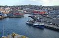
The harbor and town of Lerwick
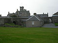
At Fort Charlotte


Attractions
- Fort Charlotte , built in 1665 to protect the harbor from the Dutch fleet ,
- the Shetland Museum ,
- the Böd of Gremista , a restored fish house from the 18th century and
- the Broch of Clickhimin from the 7th century BC. Chr.
Regular events
Regular events include the annual Shetland Folk Festival and the Shetland Accordion and Fiddle Festival.
Every year on the last Tuesday in January, the Up Helly Aa takes place as the high point of tradition .
Sons and Daughters of Lerwick
- Norman Stewart Hughson Lamont, Baron Lamont of Lerwick * 1942, British politician
gallery

Cruise ship in the harbor and masts of a sailing yacht on a stopover from Reykjavík to Hamburg.

Looking into the streets of Lerwick.

Typical houses near the port (May 1992)


Climate table
| Lerwick | ||||||||||||||||||||||||||||||||||||||||||||||||
|---|---|---|---|---|---|---|---|---|---|---|---|---|---|---|---|---|---|---|---|---|---|---|---|---|---|---|---|---|---|---|---|---|---|---|---|---|---|---|---|---|---|---|---|---|---|---|---|---|
| Climate diagram | ||||||||||||||||||||||||||||||||||||||||||||||||
| ||||||||||||||||||||||||||||||||||||||||||||||||
|
Average monthly temperatures and rainfall for Lerwick
Source: wetterkontor.de
|
|||||||||||||||||||||||||||||||||||||||||||||||||||||||||||||||||||||||||||||||||||||||||||||||||||||||||||||||||||||||||||||||||||||||||||||||||||||||||||||||||||||
literature
- Neil Wilson, Alan Murphy: Scotland. MairDumont, Ostfildern 2006, ISBN 3-8297-1568-4 .
- Peter Sager: Scotland. Architecture and landscape, history and literature. DuMont, Cologne 1997, ISBN 3-7701-3550-4 .
- Lerwick Port Authority: Strategy and Business Plan 2006/2007.
Web links
- www.visitshetland.com / Lerwick
- Lerwick Community Council , official city council website
- Lerwick Port Authority
Individual evidence
- ↑ a b 1901 - Ordnance gazetteer of Scotland (1065) Page 1057 ( 3158-8 acres )
- ↑ 2011 census
- ↑ Shetland Place Standard Final Report, The Lerwick & Bressay Area, April 2017 : Map (without Bressay )
- ↑ Shetland Islands in Statistics, 2014 , p. 10 (Population of Shetland by Area based on Census)