Bressay
| Bressay | |
|---|---|
| Overview: Mainland, Bressay and Noss, complete map here | |
| Waters | North Sea |
| Archipelago | Shetland Islands |
| Geographical location | 60 ° 8 ′ 45 ″ N , 1 ° 5 ′ 11 ″ W |
| length | 9 km |
| width | 5 km |
| surface | 28 km² |
| Highest elevation | Ward of Bressay 226 m |
| Residents | 368 (2011) 13 inhabitants / km² |
| main place | Maryfield |
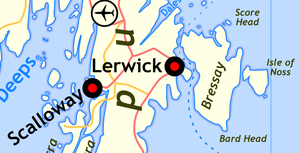
The Scottish island of Bressay belongs to the group of Shetland Islands and is separated by the Bressay Sound, only a few hundred meters east of the main island Mainland . After Lerwick , the capital of the islands is a regular ferry that takes a few minutes.
Bressay is about nine kilometers long, up to five kilometers wide and has an area of 28 km². The practically treeless island reaches a height of 226 meters in the Ward of Bressay , here is the radio and telecommunications tower for the Shetland Islands.
The island experienced its heyday in the 18th century with herring fishing . Today 368 inhabitants live here (census on May 27, 2011) scattered across the island. Agriculture (cattle breeding) still plays a certain role, but a number of farms have been abandoned for a long time and are in ruins. Tourism is not yet very developed, so that accommodation is only available to a limited extent. Numerous species of birds breed on the island's cliffs. You can take a dinghy to cross over to the neighboring island of Noss , which is under nature protection and where many seabirds also breed.
Attractions
- Lighthouse On the southwest coast is the Bressay lighthouse , built in 1858 by David Stevenson and Thomas Stevenson .
- Remnants of the Broch at Noss Sound,
- the basement of Wadbister on the Loch of Grimsetter
- some ancient cooking places like Cruester, the Bressay Stone
- the menhir of Cruetoun.
A list of the cultural monuments on Bressay can be found under List of Listed Buildings on Bressay .
See also
Web links
- Bressay at Undiscovered Scotland (English)
Individual evidence
- ↑ National Records of Scotland, Statistical Bulletin, Date: 15 August 2013, Geographical Area: Scotland, Postcode, Census Output Area, Data Zone, Inhabited Island, Theme: Population and Household estimates, 2011 Census: First Results on Population and Household Estimates for Scotland - Release 1C (Part Two)
- ↑ Northern Lighthouse Board - Portrait: Bressay Lighthouse (Eng.) Retrieved January 30, 2009


