Isle of Noss
| Isle of Noss | |
|---|---|
| View of the Isle of Noss from the island of Bressay | |
| Waters | North Sea |
| Archipelago | Shetland Islands |
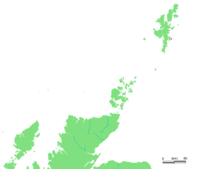
| Geographical location | 60 ° 8 ′ 49 " N , 1 ° 1 ′ 4" W |
| length | 2.9 km |
| width | 1.8 km |
| surface | 3.43 km² |
| Highest elevation |
Noss Head 181 m ASL |
| Residents | uninhabited |
| Overview: Mainland, Bressey and Noss, complete map here | |
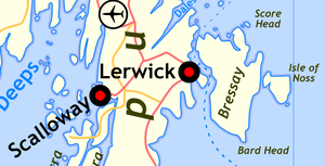
The Scottish Isle of Noss (in older publications also Ness ) belongs to the Shetland Islands , it lies east of the larger island of Bressay and is uninhabited. The name goes back to the Norwegian expression for nose .
Geography and geology
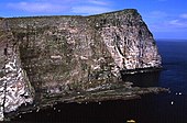
The Isle of Noss can be divided geographically and geologically into two parts. The larger, eastern one has the shape of a triangle with an extension of a good two kilometers in north-south and one and a half kilometers in east-west direction. The geological subsurface is essentially made up of rocks from the Bressay Flagstone Formation, which was formed in the middle and late Devonian Mountains: sandstone layers that are deposited under fluvial conditions and interspersed with individual, dark-colored intermediate layers of siltstone , which are classified as Old Red sandstones . The surface consists of heathland , the coast is rocky. To the east, the terrain rises to the 181-meter-high Noss Head . It is located directly on the east coast and breaks off steeply to the sea. This cliff is called the Noup of Noss .
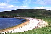
In the northwest, delimited from the main part by a low depression and the bay Voe of the Mels, a peninsula connects. It is strongly divided by further bays called Nestie Voe, Booths Voe and Papil Geo. The highest point here is the 30 meter high Hill of Papilgeo. With the exception of the north, the coast is flat and there are sandy beaches in the bays. To the west, the peninsula is bounded by Noss Sound, a strait around 180 wide that separates the Isle of Noss from the Isle of Bressay. This is also where Noss's only village, Gungstie , was located, today a desert . The peninsula lies in the area of the east of two geological fault zones that accompany the east coast of the Shetlands in this area. Here there are breccias from the surrounding sedimentary rocks , on the northwest coast is aegirinhaltiger Trachyt found.
Flora and fauna
Numerous species of seabirds breed on the cliffs of the island , while other bird species breed in the interior of the island. The Isle of Noss has been a National Nature Reserve since 1955 , a Site of Special Scientific Interest since 1983 and a protected area under the European Union's Birds Directive since 1996 . Important for the classification are populations of fulmars (Fulmarus glacialis) , gannets (Morus bassanus) , guillemots (Uria aalge) , Great Skua (Stercorarius skua) , Arctic Skua (Stercorarius parasiticus) , puffins (Fratercula arctica) and kittiwakes (Rissa tridactyla) , with the latter three on the decline.
Most of the island is characterized by the heather family , and many-flowered cornices , black crowberry and narrow-leaved cottongrass as well as occasional lice herbs , spotted orchid and common finial can also be found . Out of reach of the sheep and fertilized by bird droppings, rose root , rock catchfly and red carnation can be found in the cliff area .
history
The oldest traces of human activity on the island are the remains of a Burnt Mound from the Bronze Age. The settlement history is largely unknown, but archaeological finds can be in the area of the cemetery of Gungstie suspect that this is already in the early Middle Ages by Picts and subsequently by Vikings was used. In 1633 the residents built a small cable car to the island of Holm of Ness in the southeast . This subsequently led to an increase in the popularity of the island and prompted the writer Walter Scott to pay a visit in 1814. The population, which was 24 in 1841, 14 in 1861, and 24 in 1871, fell to 3 by 1881.
In 1870, George Vane-Tempest , the 5th Marquess of Londonderry , leased the entire island to raise pit horses for use in his coal mines in County Durham . The Gungstie Farm established by him was the first stud farm for the targeted breeding of Shetland ponies . The company was given up again in 1900.
In 1939 the Isle of Noss had around 25 inhabitants, today it is uninhabited , with the exception of two bird sanctuaries in the summer. At the local level, the island has always formed a unit with Bressay: initially as a Civil Parish , which has only been used for statistical purposes since 1929 , today as a Community Council Area.
Noss Island is visited annually by between 1000 and 2000 tourists as part of day trips, the ferry connection shown in the maps is the inflatable boat of the two bird sanctuaries. The island is used agriculturally by keeping herds of sheep .
literature
- Noss. National Nature Reserve. Scottish Natural Heritage brochure , digitized on the SNH website, PDF file, 886 kB (English)
- Glen Tyler, Emma Philip: The Story of Noss National Nature Reserve. Booklet of Scottish Natural Heritage, 2nd edition, digitized on the SNH website, PDF file, 1.3 MB (English)
- Andrew Denton, Craig Nisbet: Noss NNR Annual Report 2016. Annual report on the nature reserve, digitized on the website of the administration of the Shetland Islands, PDF file, 5.2 MB (English)
Web links
- Noss National Nature Reserve Island information on a Shetland Natural History website
- Isle of Noss in the Gazetteer of Scotland (English)
Individual evidence
- ^ So in A Topographical Dictionary of Scotland by Samuel Lewis from 1846.
- ^ Bressay Flagstone Formation in the Lexicon of Named Rock Units of the British Geological Survey .
- ↑ Old Red Sandstone of Shetland, Eastern outcrops in the Earthwise Wiki of the British Geological Survey, accessed on August 17, 2017 (English)
- ↑ Volcanic breccias and vents and associated mineralization, Shetland in the Earthwise Wiki of the British Geological Survey, accessed on August 17, 2017 (English)
- ↑ Noss National Nature Reserve on the Scottish Natural Heritage website , accessed August 17, 2017
- ↑ Noss Special Protection Area on the Scottish Natural Heritage website, accessed August 17, 2017
- ↑ Noss Site of Special Scientific Interest on the Scottish Natural Heritage website, accessed August 17, 2017


