Papa Stour
| Papa Stour | |
|---|---|
| Aesha Head on Papa Stour | |
| Waters | Atlantic Ocean |
| Archipelago | Shetland Islands |
| Geographical location | 60 ° 19 '58 " N , 1 ° 41' 46" W |
| length | 5.4 km |
| width | 3 km |
| surface | 8.28 km² |
| Highest elevation | Virda Field 86 m |
| Residents | 15th (2011) 1.8 inhabitants / km² |
| main place | Biggings |
| Historical map by Papa Stour | |
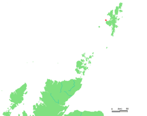
The Shetland island of Papa Stour, which belongs to Scotland, is located just a few kilometers northwest of the main island Mainland , from which it is separated by the Sound of Papa and 32 kilometers from the capital Lerwick . There are regular ferry and (infrequent) flight connections to the mainland.
Papa Stour is at most 4.5 km long and 3 km long and has an area of around 8 km². The highest elevation of the hilly and treeless island is 86 meters.
history
The population of 15 inhabitants (as of 2011) lives in the eastern part of the island mainly from cattle breeding. After the island became more and more depopulated in the 1950s, the government started an initially successful project to repopulate the island. However, in recent years the population has been falling again.
The name of the island Papa Stour indicates an early settlement of Christian priests. About 5000 years old, sparse remains are evidence of pre-Christian settlement in the Neolithic period.
In the uninhabited south of the island (the airport Papa Stour ) there is the Neolithic chamber grave ( English chambered tomb ) (also called Round Hill) Papa Stour the stone circle Doom ring and numerous rare plant and bird species. Numerous seabirds breed on the steep and sometimes bizarre shore cliffs (here a rock needle and an archway in the sea are worth mentioning).


