
Delme
| Delme | ||
 Delme near Delmenhorst |
||
| Data | ||
| Water code | EN : 4928 | |
| location | Lower Saxony | |
| River system | Weser | |
| Drain over | Ochtum → Weser → North Sea | |
| source | in Twistringen 52 ° 48 ′ 10 ″ N , 8 ° 37 ′ 53 ″ E |
|
| Source height | 53 m above sea level NHN | |
| muzzle | on the outskirts of Bremen in the Ochtum coordinates: 53 ° 5 ′ 17 " N , 8 ° 40 ′ 18" E 53 ° 5 ′ 17 " N , 8 ° 40 ′ 18" E |
|
| Mouth height | 2 m above sea level NHN | |
| Height difference | 51 m | |
| Bottom slope | 1.1 ‰ | |
| length | 46 km | |
| Catchment area | 247.86 km² | |
| Discharge at the Holzkamp A Eo gauge : 103 km². Location: 12.4 km above the mouth |
NNQ (08/13/1973) MNQ 1967/2014 MQ 1967/2014 Mq 1967/2014 MHQ 1967/2014 HHQ (10/29/1998) |
200 l / s 331 l / s 941 l / s 9.1 l / (s km²) 7.08 m³ / s 25.7 m³ / s |
| Left tributaries | Ellernbäke, Steinbach , Eschenbach , Kleine Beeke, Welse , Randgraben | |
| Right tributaries | Rote Riede, Röhenbeeke, Purrmühlenbach , Heidkruger Bäke | |
| Medium-sized cities | Delmenhorst | |
| Small towns | Twist rings | |
| Communities | Köbbinghausen, Beckeln , Groß Köhren, Klein Köhren, Harpstedt , Horstedt | |
The Delme is a 46 km long flowing water in Lower Saxony southwest of Bremen .
course
The river rises underground in Twistringen , but comes to the surface a few meters later. The source location was marked with a boulder bearing the inscription "Delmequelle - 44 km to the mouth". The river crosses the city center underground and runs through Harpstedt through the urban area of Delmenhorst . There the Delme feeds the graft system of the former Delmenhorst Castle on an island with its water . On the edge of Bremen the Delme flows into the Ochtum , a tributary of the Weser on the left . The Delme overcomes a height difference of almost 50 m along its course.
In 1995 a fish pass was set up in the Delme am Delmegarten in Delmenhorst in order to enable biological water passage from the sea to the source region again.
Flood protection
To protect the city of Delmenhorst from flooding by the Delme, as last happened in October 1998, a flood retention basin was built near Schlutter (municipality of Ganderkesee ) on an area of 125 hectares . This offers storage space for 1.8 million cubic meters of water. The project, which cost around 20 million euros and was started in 2004, was completed in spring 2014. 70 percent of the costs were borne by the state of Lower Saxony and 30 percent by Delmenhorst. The flood retention basin is maintained and operated by the Ochtumverband. It is also known as "Germany's northernmost dam".
Further south in Holzkamp , the NLWKN operates a gauge whose measured values it makes available online.
River name
The name Delme probably goes back to the Indo-European term “tel” or “stel” meaning “let something flow”.
The name Delme has not yet been interpreted with certainty. Its formation with "- (m) ana" or "- (m) end - / (m) and-" is to be assumed. The Indo-European "dhelbh-" can be assumed. It means "deepen, hollow out". Descriptions of the Delme river confirm its origin: "Geest rivers such as the Delme and the catfish have cut deeply into this base moraine with their flood plains".
Photo gallery

Delmequelle in Twistringen

Source in Twistringen
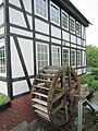
Harpstedt watermill on the Delme

At the ocean bridge

The "Kleine Delme" near Holzkamp

Delme retention basin under construction (April 2013)


Web links
- Water quality maps Weser-Nord - sub-catchment area Ochtum / Delme-Süd; therein: Delme
- Excursion destinations - Delmequelle in Twistringen
- Salmon and sea trout reintroduction
- Ochtumverband Projects - Measures using the Delme as an example
Individual evidence
- ^ Environment Lower Saxony - Area Directory Weser.
- ^ German Hydrological Yearbook Weser-Ems 2014. Lower Saxony State Agency for Water Management, Coastal Protection and Nature Conservation, p. 204, accessed on October 4, 2017 (PDF, German, 8805 kB).
- ↑ Flood protection for Delmenhorst. Lower Saxony State Agency for Water Management, Coastal Protection and Nature Conservation.
- ↑ Retention basin is "basically ready for use". NWZ-Online.
- ↑ Holzkamp gauge. NLWKN level online.
- ^ Name researcher. In: website NDR 1 Lower Saxony . Archived from the original on June 12, 2010 ; accessed on March 11, 2019 .
- ^ Jürgen Udolph (research): The "place name researcher". In: website NDR 1 Lower Saxony . Archived from the original on January 26, 2016 ; accessed on March 11, 2019 .