Ochtum
| Ochtum | ||
|
The Ochtum in Weyhe - Kirchweyhe |
||
| Data | ||
| Water code | EN : 492 | |
| location | Lower Saxony / Bremen | |
| River system | Weser | |
| Drain over | Weser → North Sea | |
| origin | Confluence of the Hache (longer) and Süstedter Bach (stronger) in the Kirchweyher See 52 ° 59 ′ 49 ″ N , 8 ° 52 ′ 47 ″ E |
|
| Source height | 5 m | |
| muzzle | between Lemwerder -Altenesch and Bremen-Seehausen in the Weser Coordinates: 53 ° 7 '36 " N , 8 ° 38' 49" E 53 ° 7 '36 " N , 8 ° 38' 49" E |
|
| Mouth height | 2 m | |
| Height difference | 3 m | |
| Bottom slope | 0.12 ‰ | |
| length | 25.6 km , with a Hache 59 km | |
| Catchment area | 917 km² | |
| Discharge at the mouth A Eo : 916.94 km² |
MQ Mq |
6.63 m³ / s 7.2 l / (s km²) |
| Left tributaries | Hombach , Stuhrgraben , Huchtinger Fleet, Varreler Bäke , Delme | |
| Big cities | Bremen | |
| Medium-sized cities | Weyhe , Stuhr , Delmenhorst | |
| Communities | Lemwerder | |
| Residents in the catchment area | 251000 | |
|
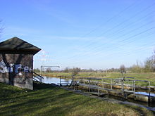
The river at the Ochtum barrier near Lemwerder |
||
The Ochtum , together with its longest source river, is around 59 kilometers long on the left tributary of the Weser . The Ochtum flows in Lower Saxony and Bremen on the southwestern edge of the Wesermarsch northwest parallel to the slope of the Syker Geest , from which most of its tributaries flow to it.
course
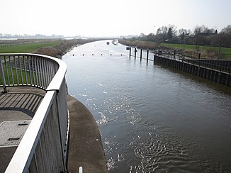
The Ochtum is created in Lower Saxony about 10 kilometers south-east of Bremen city center near Weyhe through the union of the Süstedter Bach , which is here widened to the Kirchweyher See , with the somewhat smaller but longer Hache . After a good 4 kilometers northwest it forms the border between Lower Saxony and the state of Bremen . It flows through or passes the Bremen city and districts Kattenesch , Huchting and Strom . The Links der Weser park and the nature reserve Ochtumniederung at Brokhuchting flows through it. Over time, the Ochtum was redesigned several times. An old Ochtumarm runs east of Grolland and joins the new main course (Neue Ochtum) in the nature reserve near Brokhuchting. The relocation became necessary around 1990 to expand the Bremen airport. The Ochtum touched Delmenhorst -Hasbergen and Delmenhorst-Deichhausen and opens between Lemwerder- Altenesch and Bremen-Seehausen about Ochtumsperrwerk at Unterweser -Flusskilometer 12,85 in the Weser. Their mean water flow here is a good 6.6 m³ / s. To the west of the estuary there is an oxbow lake, the Alte Ochtum , from the time before the river was straightened .
Storage polder
Below Huchting, the Ochtum lowlands in front of the main dykes are characterized by a system of storage polders protected by summer dykes , which are filled in sections by fixed overflow points on the side facing away from the west and north-west winds during floods. This system of summer polders ensures that floods only reach the main dike lines with a significant delay. However , this was ineffective during the storm surge in 1962 , as the polders were already completely filled during the vortide on the early afternoon of February 16 and could not empty in the subsequent ebb. The main tide on the night of February 16-17 thus met completely filled polders.
Due to the existence of this system of storage polders, it was possible to dispense with the construction of an additional pumping station in the mouth area during the construction of the Ochtum barrier. Since the barrage was put into operation, the storage polders have been tasked with absorbing the water brought in from the tributaries of the Ochtum in the event of a storm surge.
history
The settlement of Vieland is documented in 1158 in the Bremen document book (IS 46), when Emperor Friedrich I (Barbarossa) allowed the cultivation of the breaches of the insula Bremensis between the Weser and Ochtmund (= Ochtum estuary). The name insula Bremensis indicates that the river probably still had a tributary to the Weser near Arsten. The Ochtum was later also written Ochen , Ochtmoni or Oggen .
In 1234 the battle of Altenesch took place.
From Arsten to the estuary, the Ochtum became part of the Bremen Landwehr around 1309 with the Arster Tower, the Kattenturm ( Kattenthorn ) and the Warturm ( Torn to de Warebrughen ). The consent of the Counts of Oldenburg to broaden the ochtum had already been obtained in 1297.
The first of the Ochtum regulations was in 1400. In
1571 the Ochtum dyke broke due to a flood coming from the Upper and Middle Weser area.
In 1833 the Ochtum was relocated to a side bed in the Warfelde, whereby it lost many of its curves. The drainage of the water has been improved.
During a severe flood of the Middle Weser in 1881 the dike at Hoya broke , so that a large part of the flood was discharged via the Ochtum.
The Weser correction from around 1900 by Ludwig Franzius led to a dramatic increase in the influence of the tides in the Ochtum. Many fords were only passable to a limited extent or could no longer be used at all. At today's Ochtum Bridge in Bremen-Strom , the ford was replaced by a ferry.
A heavy flood coming from the Upper Weser area flowed over the Ochtum lowlands in 1926.
Between Bremen-Strom and Deichhausen, a road connection was built in 1937 over an embankment and the Stedinger Bridge was built.
Heavy ice in 1941 led to the destruction of bridges and weirs.
During the storm surge series from December 19 to 24, 1954 , the entire Ochtum lowland between the mouth and Bremen-Huchting was flooded.
The 1956 flood in July from the Upper and Middle Weser area flooded the dikes at Wienbergen and Oiste and flooded the Ochtum lowlands.
During the storm surge in 1962 on the German North Sea coast on the night of February 17, large areas of the Bremen urban area to the left of the Weser were flooded via the Ochtum and the connection from Neustadt to Huchting was cut. Several people were killed in the allotment garden areas of Huchting, which were inhabited by the bombed out. (see also map of the flooded areas)
On January 28, 1966 just before 19:00 that overthrew Convair CV-440 D-ACAT of Lufthansa during a go-around maneuver to Kladdinger meadows of Ochtum south. All 46 occupants of flight LH 005 were killed, including a team from the Italian Olympic swimming team and actress Ada Chekhova .

In November and December 1973, several storm surges caused severe damage in the area between the mouth and the Bremen district of Huchting. A person was killed in the process.
In January 1976, two very severe storm surges caused severe damage between Huchting and the Ochtum estuary. On January 3, 1976, the storm surge caused by the Capella storm exceeded the extreme values of the flood catastrophe in 1962.
On June 2, 1976, the Ochtum barrage near Altenesch was completed, for which the Lower Saxony State Agency for Water Management, Coastal and Nature Conservation ( NLWKN ) was responsible. The previous state port of Ochtum was relocated to its current location below the Ochtum barrage. Commercial shipping on the Ochtum was discontinued.
In 1989/1990, a 5.4 km long section of the Ochtum was laid through the park to the left of the Weser so that the existing runway at Bremen Airport could be fully used. The approximately 5 km long course of the Ochtum north of Grolland remained. It is fed underground with water from the relocated Ochtum and emerges on the northern edge of the airport.
environment

In 1989/1990 the Ochtum was relocated on a section with extensive renaturation measures and significant involvement of the Bremen Water Management Office . A meandering river course was created with near-natural bank and shallow water zones and formed the backbone of the “ Ochtumpark ”.
According to the water quality map of the state of Bremen from 2000, the Ochtum was classified in quality class II , moderately polluted, up to the Bremen electricity area. In May 2002 the fish population was examined in Huchting; accordingly, bream are the most common fish, along with roach , eel and white bream . The river is influenced by the tide through the Weser . In the event of flooding , the Ochtum barrage prevents the neighboring lands from being flooded.
In 2019, fish from the Ochtum were examined for per- and polyfluorinated alkyl compounds (PFAS). Due to the heavy exposure to perfluorooctanoic acid , we do not recommend consuming the fish.
Economy and Transport
Until the 1950s, the Ochtum was used as a traffic route for the transport of goods - especially for the transport of peat from the Teufelsmoor, which was used as fuel. Reloading points were u. a. at the Hasberger Stau der Delme , below the Hasberger watermill and in Bremen-Strom. For this reason, both the Hasberger Delmestau and the Ochtumstau in Bremen-Strom were provided with locks when they were built. The traffic took place for centuries with the hallways common in the region. Later, motorized Tjalken were also used, which led to private loading areas in the river section up to the Hasberger Ochtumstau.
Another port used by commercial shipping was located directly at Ochtum. Until the mid-1970s it was used for handling building materials, especially sand and gravel. After the construction of the Ochtum barrage, this port was relocated to the area below the barrage in the summer of 1976. This transshipment point has been used for the loading of rotor blades for offshore wind turbines since the end of 2011. The entire river area above the barrage is closed to commercial shipping. The only exception to this are vehicles for fairway maintenance .
Today the Ochtum is only used by water sports clubs and occasionally by passenger shipping (charter shipping) as a traffic route. The paths on the Ochtum dykes are popular bicycle and inline skating paths .
Trivia
The Ochtum is also mentioned in the song Delmenhorst by Element of Crime .
See also
Individual evidence
- ↑ Free Hanseatic City of Bremen: Detailed description of the waters with catchment areas> 10 km² , implementation of the EU Water Framework Directive in the State of Bremen, 2004; accessed on November 1, 2013 (pdf; 3.8 MB)
- ↑ Sum of the gauge values Steimke (Hache), Südweyhe (Süstedter Bach), Kirchseelte (Klosterbach) and Holzkamp (Delme) increased by the drainage of the remaining catchment area (6.5 / s.km² on 34.15 km²), derived from neighboring gauge catchment areas and from the Hydrological Atlas of Germany - Annual discharge height
- ↑ Weser river basin community: Weser river basin management plan 2005 - inventory of sub-area Tideweser
- ↑ Ludwig Deike: The emergence of manorial rule in the elder colonies on the Niederweser . In: Publications from the State Archives of the Free Hanseatic City of Bremen Issue 27, Schünemann, Bremen 1959, p. 27.
- ↑ Bremer Urkundenbuch, Vol. I No. 516 of February 2, 1297
- ^ Deichverband on the right bank of the Weser: Map of the flooded areas in Bremen 1962
- ↑ Final report on the examination of fish in Lower Saxony's Ochtum for perfluorinated alkyl substances (PFAS) in 2019. (PDF; 1 MB) In: laves.niedersachsen.de . 2019, accessed December 19, 2019 .


