Weser correction

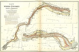
→ This map in landscape format
Under Weser correction is straightening the lower Weser between the orifice in the North Sea in Bremerhaven and the ports in Bremen understood, the end of the 19th century by the City of Bremen was performed. It enabled seagoing vessels with a draft of up to 5 meters to reach the Bremen ports in one pass at high tide .
history
Up until the High Middle Ages , the Weser in Bremen was up to 8 m deep. The high medieval colonization led to the loss of forest land and the expansion of arable land to a strong increase in erosion in the catchment area of the river Weser. Since around 1400, the siltation of the Lower Weser was so strong that loaded large seagoing ships could no longer reach the port on the Bremen Schlachte . The port of Vegesack , located 20 km downstream, was temporarily the port of call, and since 1830 Bremerhaven . Here or in the middle of the Unterweser the ships were unloaded and the goods to smaller Weser barges or barge unloaded. Any reloading outside of the Bremen warehouses and offices was a competitive disadvantage for Bremen. So modern ocean-going ships should be able to sail the Lower Weser as far as Bremen.
This task was taken over in 1875 by the Bremen senior construction director Ludwig Franzius . For years he collected data on the course of the river, had the speed and direction of the flow observed and the amount of water measured. Exact maps of the region were drawn up in 1878/1879 , see figure on the right. At the end of 1881, the plans were ready to be implemented. However, the construction work did not begin until July 1887, after Bremen had already built its "Freeport I", today's "Europahafen".
Huge amounts of earth had to be moved. Large excavators removed 30 million cubic meters of sand from the river bed , the channel of which was deepened to five meters. Loops were cut off, the banks paved with 1.2 million cubic meters of bushes and stone packings, and the flow cross-section reduced by groynes . From an overgrown river bed in the marshland with sandbanks and side arms, a long canal with smoother banks was created in almost eight years of work, which narrowed more and more and led the flood stream in a concentrated manner up to Bremen.
When the measures were completed in April 1895, Franzius had realized his idea of a straight, funnel-shaped lower course of the river . The cost of the correction was 30 million marks from Bremerhaven to Bremen and again as much on the stretch of the Outer Weser from Bremerhaven to the open sea.
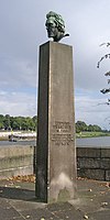
The monument of the hydraulic engineer stands in Bremen directly on the Weser near the Wilhelm-Kaisen-Bridge , with the inscription: "Ludwig Franzius [...] he opened the way to the city of Bremen for world shipping" .
The expansion of the Lower Weser resulted in deep erosion in the course and above the expanded river with considerable sand discharge. The tidal range had slowly sunk to 20 cm since Bremen was founded. At the gauge at the Great Weser Bridge , the spring tide was 30 cm, the nip tide 0 cm. After the very first measures, an average tidal range of 40 cm was measured there in 1890, then 145 cm after the work was completed in 1900. After further deepening the Weser, it is now up to 5 meters ( Oslebshausen gauge ). In order to prevent the bed erosion from progressing into the Mittelweser, the Weser weir in Bremen- Hastedt was built between 1906 and 1911 (replaced by a new one in 1993).
Web links
swell
- Ludwig Franzius: The correction of the Lower Weser (1888), plus a map portfolio
- also includes the full text of his work Project of the Correction of the Lower Weser , published in 1882 ,
- is available in the reading room of the Bremen State Archives without pre-order
- Fixed number of the journal of the Association of German Engineers for the 55th Annual General Meeting. Bremen 1914, pp. 1–27 and map attachment
See also
Individual evidence
- ^ Telephone information from the Bremen Waterways and Shipping Office , subject area Hydrology, from March 26, 2014

