
Groepelingen
| District of Bremen Groepelingen |
||
|---|---|---|
  |
||
| Basic data | rank | |
| Surface: | 9.791 km² | 16/23 |
| Residents : | 37,187 | 5/23 |
| Population density : | 3,798 inhabitants per km² | 6/23 |
| Proportion of foreigners: | 32.5% | 2/23 |
| Unemployment rate: | 26.1% | 2/23 |
| Coordinates : | 53 ° 8 ' N , 8 ° 45' E | |
| Districts: |
Lindenhof Gröpelingen Ohlenhof In den Wischen Oslebshausen |
|
| Postcodes : | 28237, 28239 | |
| District : | west | |
| Local office : | west | |
| Website: | West local office | |
| All area information as of December 31, 2014. All demographic information as of December 31, 2016. |
||
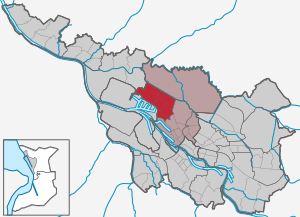
Gröpelingen ( Low German Gröpeln ) is a district of Bremen and belongs to Bremen's western district.
Geography and districts
Gröpelingen is located on the right bank of the Weser approx. 5 km west of the center of Bremen.
The neighboring districts are Walle in the east, harbors in the south, Burglesum in the west and Blockland in the north.
Groepelingen

Area: 1.47 km², 8928 inhabitants
Until the construction of the neighboring ports and industrial plants in the 19th century, Gröpelingen was initially characterized by a village. This part of the town was greatly changed by industrialization. Many employees who worked in the port industry lived here. As a result of the conversion to containers and the shipyard crisis, there were major changes in the port industry, which also affected the structure of this district. The district is characterized by a mixture of commercial and residential properties.
Lindenhof

Area: 0.74 km², 7977 inhabitants
The Lindenhof district has developed into a multicultural district due to the influx of guest workers and other immigrants since the 1960s. The Fatih Mosque , the largest mosque in Bremen, was built for Muslim immigrants from Turkey on the edge of the port . Since the beginning of the 21st century, the district has also been preferred as a place of residence by students and artists.
Ohlenhof
Area: 1.32 km², 9488 inhabitants
The district of Ohlenhof has the most inhabitants and, in contrast to the other districts in Gröpelingen, has developed into a residential area. In addition to several schools, the Ohlenhof adventure farm is also located here . This adventure farm offers children, young people and interested adults the opportunity to meet animals and a natural environment. The facility should also serve to improve the promotion and leisure activities in the west of Bremen.
In the wipes
Area: 2.16 km², 14 inhabitants
Oslebshausen

Area: 3.97 km², 8653 inhabitants
The small village of Oslebshausen ( Low German Oshuusen ) changed its face completely after the construction of the neighboring ports and industrial companies. A district developed with single houses, terraced houses and mainly three to four-story apartment blocks for the residents who work in the ports.
In 1823 the doctor Hirschfeld laid out an estate with a park, which the judge Wilhelm Focke and then Johann Ludwig Schrage acquired. In 1890 he set up the Adelenstift here, named after his wife Adele. When the manor house burned down in 1901, an existing new building was built. The Adelenhaus had a close connection to the Diakonissenhaus ( Diako Bremen ) of the Bremen Diakonie . The Adelenstift of the Ludwig Schrage Foundation became a day-care center after the Second World War. The Diakonie Hospital was built on parts of the site .
The penal and correctional facility with its widely visible prison church was built from 1871 to 1874 in the neo-Gothic style from bricks according to plans by the architect Alexander Schröder and then considerably expanded. Most of it is a listed building.
The old school building on Oslebshauser Heerstraße was built in 1907 as the Oslebshausen community school .
The Protestant Nikolaikirche Oslebshausen was built in 1929/30 according to plans by Walter Görig .
Politics, administration
Advisory Board
The Gröpelingen Advisory Board is also responsible for the industrial ports district in the ports district . It meets regularly and usually in public in the local office or in other institutions such as B. Schools. The advisory board is composed of the representatives of the political parties or individual candidates elected at the district level. The advisory board elections take place every four years, at the same time as the elections for the Bremen citizenship . The advisory board discusses all issues of the district that are of public interest and makes decisions on this, which are passed on to the administration, the state government and the townspeople. He forms specialist committees for his work. The advisory board has its own budget for district-related measures.
Since 2008 the district council has also supported the formation of a youth council.
Advisory board spokesman is Dieter Adam (SPD). His deputy is Raimund Gaebelein (DIE LINKE).
Local office
The local office has been a local administrative authority since 1946. In 1979 the West Local Office was set up for the Advisory Councils Gröpelingen, Walle and Findorff. It supports the advisory board in its political work. It is intended to participate in all local tasks that are of public interest. It is led by a local office manager proposed by the advisory board and confirmed by the Senate.
The head of the local office is Ulrike Pala (SPD).
history
Surname
The name Gröpelingen is derived from the old word “gropen” or “grüppe” for ditch and “linga” for “the people of”, as the first inhabitants settled on a dune ridge that was next to a natural drainage ditch to the Weser. The “Gropelinge” settler clan was the one who lived by a ditch. The later dynasty of the Knights of Gröpelingen adopted this name, but, ignorant of the etymological meaning of the word, chose a Grapen (pronounced: Groopen), a kettle with three feet, as a coat of arms symbol. The names Gröpelingen, Gröpeln or similar also appear as names for other places in northern Germany that are located on an elevation next to a ditch. These are the places Gröblingen near Warendorf on the Ems and Gräpeln near Oldendorf north of Bremervörde. The name Oslebshausen went through many changes over the centuries; its origin is therefore difficult to interpret. Since the etymologically “younger” ending -hausen, in contrast to -lingen, indicates an area that has already been settled, the name could be derived from the house of a settler called “Oslev”.
Middle Ages to 1800
860 was the first documentary mention of Oslebshausen. Gröpelingen was first mentioned in a document in 1218 as the land of the Knights of Gröpelingen. In the 13th century, a branch of the family belonged to the upper class in Bremen, so u. a. Luder van Gropelinghe . The knight and councilor of Bremen Arnd von Gröpelingen , murdered in 1304, became famous for the unrest that went with it.
The villages of Gröpelingen and Oslebshausen were in the Goh Werderland. A hundred years later, the Gröpelinger Church was first mentioned in a document in 1331. With the extinction of the Gröpelinger knight family in the 15th century, the country came under the rule of the Bremen council . Since 1691 there was a mill in the village of Gröpelingen, which burned down in 1788 and was then rebuilt.
From 1741 to 1803 Oslebshausen and Wischhusen belonged to the Electorate of Braunschweig-Lüneburg - later named the Electorate of Hanover - and then returned to Bremen in 1803.
1800 to 1900
In 1812 Gröpelingen had 342 and Oslebshausen 199 inhabitants. In 1817 Gröpelingen and Oslebshausen were subordinated to the landlord in the Bremen council. The construction of the Chaussee - today Heerstraße - as far as Oslebshausen took place from 1820 to 1821. Bremen merchants now set up their summer residences in Gröpelingen and Oslebshausen and excursion restaurants were created. The innkeeper Keese built the Flora amusement park during this time , the hall of which was popular for dancing and other events. In the 1930s, violent riots between the political parties were to take place here. The flora existed until 1945. A single-class parish school in Gröpelingen therefore had to be renewed in 1822 and expanded by one class in 1848. In 1874 the school was expanded to 4 classrooms and in 1881 there were 6 classes. In 1842 Gröpelingen with Wischhusen had 613 inhabitants and in 1885 it had 1,710 inhabitants. In 1879 the miller Garbade operated the windmill (motorized from 1890) on Luchtbergstrasse. This mill changed hands and burned down in World War II.
The penal and correctional facility in Oslebshausen was built from 1871 to 1874 as a " penitentiary " according to plans by Alexander Schröder in neo-Gothic style. With the sand from the Weser correction, the depressions in the Gröpelinger dune range could be filled from 1883 to 1886. It was now possible to develop further on Gröpelingen.
From 1885 to 1914 the ports were built and industry settled. Gröpelingen is changing fundamentally. The village with its farms, summer houses and tourist restaurants is disappearing. Simple residential buildings in dense development for the immigrant port workers from Germany, Eastern Europe and Italy emerged. The church school was taken over by the political community in 1889. Further new school buildings were necessary in 1897 and 1901 for further 4 and 6 classes. In 1891 and 1902 respectively, Gröpelingen was incorporated into the city of Bremen, first in the southern part and then all areas. The school was taken over by the city in 1902.
From 1900


The massive development made it necessary to run the tram line to Oslebshausen from 1901 to 1903. In the years 1902 to 1905 the small shipyard AG "Weser" moved from the Stephanikirchweide to Gröpelingen. The shipyard, often referred to as "Use Akschen" by long-established Bremen residents - a street of the same name now runs next to the former shipyard site, has become one of the largest shipbuilding companies in Germany and the largest employer in Gröpelingen. The preserved administration building of the shipyard was built between 1903 and 1905.
In 1905 Gröpelingen had 5,335 and Oslebshausen 1,461 inhabitants. The first multi-storey residential complex in Breitenbachhof was built by the Eisenbahn Spar- und Bauverein from 1913 to 1915. The Bremer Schützengilde was founded in 1904 and resided in the new Schützenhof, Bromberger Straße 117. From 1931 to 1943 there was still an inn here, in 1908 the General Gröpelinger Sportverein was founded with around 180 members. To relieve the school on Kirchenallee, a new school had to be opened at the Ohlenhof in 1908, initially with 6 classes, which was later expanded to 10 and finally to 16 classes in 1919. The school building was destroyed in the air raids on Bremen during World War II . 1914 at the Wischhusen Street and the former Gabriel Street, later Pestalozzi street, opened a "free school" with six classes for 300 students in 1919 elementary school was in 1932 and the name of school at the Pestalozzi Street received. In 1934 there was a girls 'school on Pestalozzistraße and the boys' school on Wischhusenstraße. A small bathing establishment of the AG Weser only existed from 1910 to 1914. The bathing establishment at Ohlenhof was built in 1914. The bath was expanded in 1929, then destroyed in 1945 and then rebuilt.
After the First World War , cooperatives or the state quickly built further housing estates as social housing. The working-class suburb of Groepelingen was a stronghold of the SPD and KPD during the Weimar Republic, with nicknames like Little Moscow and Rotes Groepelingen . Numerous militant conflicts took place with supporters of the NSDAP from 1930 onwards . In 1921 Oslebshausen was incorporated into the city of Bremen. In 1926 the tram depot was built according to plans by Rudolf Jacobs and converted in 1992. The neo-Gothic Protestant church in Oslebshausen - based on plans by Walter Görig - was inaugurated in 1930. The Catholics formed the St. Marien church community around 1920. The Protestant Thank You Church in Gröpelingen, built in 1935, was destroyed by bombs in 1944.
"Third Reich"
After the seizure of power of Hitler in early 1933 the majority of the workers of the AG Weser was the Nazi regime skeptical about. During the war years, around 200 shipyard workers were illegally organized in the resistance against National Socialism .
During the November pogroms in 1938 , SA men attacked the Jewish retirement home at Rosenak-Haus on the corner of Gröpelinger Heerstrasse and Morgenlandstrasse and drove the elderly out into the streets. A plaque reminds us that many of them were victims of the Shoah .
During the Second World War, almost 19% of the workforce at the AG Weser were foreign prisoners of war and forced or “ Eastern workers ”. In 1944 an additional 1,500 prisoners from the Neuengamme concentration camp were deployed. They lived in the barracks of the satellite camps a . a. on the Gröpelinger Schützenhof site. The premises of the BREMER rifle guild was confiscated at the beginning of the war, the wash house and kitchen and four barracks were built in which Indian seamen were initially interned, followed by 132 Sinti in February 1940, who were transported to the Belzec extermination camp . In December 1944, 700 concentration camp prisoners from Neuengamme were interned here, 267 of whom died before the death march on April 7, 1945, mainly Jews from Hungary and Poland, as well as Belgians, including 6 residents of the Meensel-Kiezegem community in Flemish- Brabant, in which SS raids took place on August 1 and 11, 1944, during which 68 of the 900 inhabitants were deported to Neuengamme. During the air raids on Bremen in 1944, many buildings and facilities were destroyed in the ports and residential areas of Walle and Gröpelingen, including the Gröpelingen village church from the Middle Ages.
reconstruction
As early as the 1950s to 1970s, the typical working-class district was rapidly rebuilt with new apartment blocks and row houses. The school on Kirchallee - used operationally by AG Weser during the war - was from 1946 a vocational school again, then a secondary school and finally a primary school. New schools emerged. The St. Andreas Church in Lindenhof on Danziger Straße was built from 1948 to 1949, expanded to include the parish hall from 1955 and the St. Philippus church on Seewenjestraße with the parish hall from 1967 based on plans by Fritz Schumacher and C. Hübner. The double-towered, modern Catholic Nikolaus-Kirche, Beim Ohlenhof 19, was built in 1958/59 as a concrete frame structure with red stone infills and a kindergarten was added. Then in 1969 the red-stone, Catholic St. Joseph Church was consecrated in Oslebshausen, Alter Heerweg 37.
In 1960 Gröpelingen had 48,744 inhabitants in all parts of it. From the late 1960s, with the arrival of Turkish workers, a Turkish-speaking milieu emerged with grocery stores, travel agencies, sports clubs, doctors and lawyers. The area around Lindenhofstraße was later colloquially called "Little Istanbul ".
The Hafenrandstrasse was mostly expanded to four lanes from Walle to Oslebshausen in the early 1980s. The independent tram route came in the middle of the street. In 1982 the old Gröpelinger school on Kirchallee, which last served as a primary school, had to be demolished.
Closure of AG Weser
Werft AG "Weser" was by far the most important company in Gröpelingen. From 1975 onwards, due to deficits in productivity, shipbuilding also shifted for German shipowners to countries such as Japan or South Korea , where state subsidies enabled systematic investment in modern production structures. A shipyard crisis captured the German shipbuilding. In 1983 the Krupp Group was no longer able to avert the bankruptcy of AG “Weser” due to its reluctant sources of finance. After long, ultimately failed negotiations and workers occupying the shipyard, the shipyard was closed at the end of 1983. Its end had far-reaching consequences for the district - Gröpelingen became a problem district .
City district in transition
From 1990 the redevelopment of the district took place with the help of various funding programs for urban development , through the EU program URBAN , through the state program WiN (Living in Neighborhood), through the federal state program Die Soziale Stadt and through an emergency program of Bremen. In 2008 the general funding program was completed.
In 1995 the district with 34,982 inhabitants had significantly fewer than 1960. In 1999 the inauguration of the Fatih Mosque took place in Stapelfeldtstrasse in the district of Gröpelingen. In 1999 the West District Library was opened in a new building on Lindenhofstrasse . The opening of the Torhaus Nord as a new cultural center in Gröpelingen took place in 2001. Around 2002, the 44,000 m² Bremen Space Center was built for 170 million euros; a ride and amusement, leisure and shopping center that was hoping for 1.4 million visitors a year. A large part of the shops could not be rented out. The modern adventure center did not have the expected success and in October 2004 it had to be closed again eight months after its opening due to a lack of visitor numbers. In October 2008, the now pure shopping center Waterfront Bremen opened in the converted building complex .
An international storytelling festival, the Traces of Fire, has been taking place in Lindenhofstrasse since 2007 and attracts several thousand visitors every year.
Population development
| Town / district | 1812 | 1842/55 | 1885 | 1905 | 1939 | 1955/60 | 1975 | 1995 | 2007 |
|---|---|---|---|---|---|---|---|---|---|
| Groepelingen | 802 | 613 | 1,710 | 5,335 | 36,537 | 10,480 | 8,947 | 8,975 | |
| Oslebshausen | 199 | 256 | 736 | 1,461 | 10,700 | 13,351 | 8,492 | 9,029 | 8,585 |
| Lindenhof | 8,387 | 7,744 | 7,963 | ||||||
| Ohlenhof | 10,677 | 9,395 | 9,475 | ||||||
| In the wipes | 369 | 59 | 15th | ||||||
| district | - | - | - | - | - | 48,744 | 38,403 | 35,174 | 35,013 |
Gröpelingen district: different sources for 1812, information for 1842, in 1960 also for the districts of Lindenhof, Ohlenhof and In den Wischen
Culture and sights

Buildings
- The administration building of AG Weser was built from 1903 to 1905 according to plans by Diedrich Tölken.
- The Andreas Church in Lindenhof, Danziger Straße 20, was built from 1948 to 1949 according to plans by Otto Bartning and Friedrich Schumacher .
- The neo-Gothic prison in Oslebshausen was built from 1871 to 1874 according to plans by Alexander Schröder and Johannes Rippe .
- The Espabau's Breitenbachhof was built according to plans by Rudolf Jacobs in the reform style from 1915 to 1919.
- The Feierabendweg (Bremen) estate was built in 1914 as a terraced house with a garden corridor in Ohlenhof
- The Wohlers Eichen residential complex from 1971/73 of the Bremer Treuhand, Wohlers Eichen 30, Architectural Association Team 4.
- The settlement on the Kruge in the Ohlenhofviertel from 1997 of the Bremen Society, Maria-Krüger-Straße / Auf dem Kruge, architects Manfred Schomers and Rainer Schürmann.
Monuments, art


- To the shift , bronze sculpturefrom 1983 by Waldemar Otto as a reminder of the working life as well as the political struggles and shipyard occupation of the former shipyard workers of the AG Weser .
- Working hands , bronze sculptureon the Bürgermeister-Ehlers-Platz on Pastorenweg from 1987 by Bernd Altenstein as a reminder of the Großwerft AG Weser.
- Mural to commemorate the persecution and resistance in the Nazi dictatorship ; by Jürgen Walter, attached in 1978 to the bunker Pastorenweg 70 / Grasberger Straße
- Memorial stone in memory of the 162 Jews from Bremen who had to march from the old grammar school to the Oslebshausen prison during the November pogrom in 1938 ; Erected in 1988 at the entrance to Oslebshausen prison
- Memorial stone in memory of around 4,000 forced laborers and prisoners of war in World War II ; built at Nonnenberg 40 in Oslebshausen
- Memorial plaque with a relief by Holger Voigts in memory of the prisoners of the Riespott concentration camp there at the time ; attached in 1984 to a building of the Klöckner-Hütte
- Memorial for the Dutch slave laborer Homme Hoekstra (1911–1944) Rear of the building on Schwarzen Weg 92 from May 6, 1999 (former Tirpitz camp)
- Memorial plaques at the former Schützenhof concentration camp, Bromberger Strasse 117, for the interned Indian seamen, the 132 Sinti deported to Belzec, the 267 dead of the external concentration camp on April 29, 2002, plaque for the dead of the Belgian community of Meensel-Kiezegem on August 29 2004, stumbling block for the Hungarian Jew László Schächter (1909–1945)
Parks, green areas
- The Oslebshauser Park from was developed in 1931.
- The west green corridor from Oslebshausen through Gröpelingen to Walle was built in 1953.
- The large allotment gardens range from In den Wischen to Waller Feldmarksee with its bathing beach.
Public facilities
General

- West local office, Waller Heerstraße 99 at the Walle-Center
- City Library West , Gröpelinger Bibliotheksplatz
- Police station Gröpelingen, Gohgräfenstrasse 49
- Police station Oslebshausen, Sperberstrasse 21
- Neighborhood house Helene Kaisen in Gröpelingen, Beim Ohlenhof 10 has been a Bremen town house since 1952
- Bürgerhaus Oslebshausen e. V. , Am Nonnenberg 40, has been a Bremen community center since 1977 .
- Correctional facility Oslebshausen of the correctional facility Bremen (JVA), Sonnemannstrasse 2
schools
- Oberschule Ohlenhof Halmerweg, Oberschule since 2012.
- Oberschule im Park All-day school and high school since 2011.
- School on Fischerhuder Strasse , elementary school.
- School on Oslebshauser Heerstraße , elementary school as an all-day school, Oslebshauser Heerstraße 115.
- School on Pastorenweg in Lindenhof, elementary school.
- School on the hay , elementary school as an all-day school.
- School on Halmerweg , Ohlenhof, elementary school.
- New high school Gröpelingen , Ernst-Waldau-Str. 1, all-day school since August 2010 (formerly Johann Heinrich Pestalozzi School).
- Comprehensive school Bremen-West at Lissaer Straße 7 in Walle, all-day comprehensive school and secondary school with approx. 530 students.
- Vocational school for metal technology , Reiherstrasse 80 in Oslebshausen
- Nursing school of the Evangelical Diakonissenanstalt , Gröpelinger Heerstraße 406/408
- vhs West of the Bremen Adult Education Center , Gröpelinger Heerstraße 226
- Private school Mentor gGmbH , Schwarzer Weg 96 in Ohlenhof, grammar school.
- The Catholic elementary school St. Joseph School , Alter Heerweg 35 in Oslebshausen, was closed at the end of the 2013/2014 school year.
Social
- about 13 kindergartens
- Youth hostel Gröpelingen , Marienwerderstraße 6
- Youth hostel Oslebshausen , Oslebshauser Heerstraße 224
- Community building on Stuhmer Strasse
- AWO - Service Center Gröpelingen , Gröpelinger Heerstr. 248
- Service Center West , Gröpelinger Heerstr. 248
- AHB Residenz Oslebscity , Am Oslebshauser Bahnhof 2
- Evangelical Deaconess Mother House Bremen , Adelenstrasse 68
- Ella-Ehlers - Haus , Social Center Bremen West, Dockstrasse 20
- Gröpelingen foundation village of the Bremer Heimstiftung , Elbinger Straße 6
- BVO - Citizens' Association Oslebshausen , Oslebshauser Heerstr. 87
Churches, religious communities


- Evangelical parish Gröpelingen and Oslebshausen , Lindenhofstraße 18 with the
- Andreas Church from 1950 in Gröpelingen, Danziger Strasse 20 / Lütjenburger Strasse, based on plans by Otto Bartning and Friedrich Schumacher
- Nikolaikirche (Oslebshausen) from 1930, Ritterhuder Heerstraße 1 / Oslebshauser Heerstraße , based on plans by Walter Görig
- Evangelical Emmaus Church of the Diakonissenkrankenhaus, Gröpelinger Heerstraße 406, church from 1961 based on plans by Eberhard Gildemeister .
- Evangelical Philippus Church , Seewenjestraße 92–98, church from 1966 based on plans by Friedrich Schumacher and Claus Hübener. In 2009 it was converted into a youth church.
- Catholic parish Sankt Josef in Oslebshausen, Alter Heerweg 37, church from 1967 based on plans by Karl-Heinz Bruns.
- Catholic St. Nicholas Church from 1959, Beim Ohlenhof 19, architect Josef Feldwisch-Drehntrup.
- Fatih Mosque Bremen from 1998, Stapelfeldtstrasse 9, architect: Asur Yilmaz.
- Mevlana Mosque , Lindenhofstrasse 33–35.
Sports
Investments
- District sports facility Lissaer Straße
- Westbad of Bremer Bäder GmbH , Waller Heerstr. 293 A
- The Gröpelinger sports mile connects the districts of Oslebshausen, Ohlenhof and Gröpelingen on its route
sports clubs
- General Gröpelinger Sports Club from 1908 ( AGSV Bremen ), Oslebshauser Heerstraße 253
- Bremen Rifle Guild from 1904 , Bromberger Strasse 117
- Bremer Sporttaucherverein Spacediver , Alter Winterweg 12
- 1. Bremer Squash Club , Johann-Kühn-Straße 27
- KSV Vatan Sport , Ortstrasse 14
- SVGO - Sportgemeinschaft Grambke-Oslebshausen , Sperberstraße 3/5
- Gymnastics and Lawn Sports Club Bremen ( TuRa Bremen ), Lissaer Straße 60
- Water sports club Gröpelingen , Sportweg 1
- Citizens' Association Oslebshausen (BVO), Oslebshauser Heerstr. 87
Economy and Transport
economy
Gröpelingen itself is essentially a residential area with a center for shopping and services in the Lindenhof district and along the Gröpelinger Heerstraße. The economy is shaped by the adjoining district of ports with the Überseestadt and its industrial and commercial operations in the port sector.
In 2008, the Waterfront shopping center opened on the Akschen industrial park near the shipyard.
The Diako Hospital of the Bremen Diakonie is located in Gröpelingen . There is an industrial area near the industrial harbors access road.
traffic
Public transport
- The tram lines 2, 3, 5 and 10 of the Bremer Straßenbahn AG (BSAG) connect the district via the Gröpelinger Heerstraße or via the so-called Hafenrandstraße with the district Walle , with Überseestadt and with the district of Bremen-Mitte .
- The bus routes 80 to 82, 90 to 93 as well as 95, 660, 680, N7 and N61 connect Gröpelingen with Bremen-Nord, the ports, the Oslebshausen train station and the northern surrounding communities.
- The Bremen-Oslebshausen stop is on the Wunstorf – Bremerhaven seaport railway line and has been served by the Bremen / Lower Saxony regional S-Bahn since December 11, 2011 .
Streets
Gröpelingen can be reached via the A 27 motorway , exit HB-Oslebshausen / Gröpelingen in the north-west and exit HB-Überseestadt in the south-east (via Walle). The A 281 motorway is still under construction and already has an exit HB-Burg-Grambke , which leads to Hafenrandstrasse (near the industrial port ) to Oslebshausen and Gröpelingen.
The main access roads of the district in the longitudinal direction are the Oslebshauser - and the Gröpelinger Heerstrasse and at the port the so-called Hafenrandstrasse with the streets Beim Industriehafen, Stapelfeldtstrasse , Werftstrasse and Bremerhavener Strasse in Walle.
Bike path
In a west-east direction, a central bike and footpath leads through an elongated green zone from Oslebshausen through Ohlenhof and the Gröpelingen district to Walle to the city center. Popular destinations for cyclists are the Blockland with the Wümme cycle path and the Blocklander Hemmstraße on the Kleine Wümme as well as the allotment garden area In den Wischen to the Waller Feldmarksee .
Ferries
Since 2013, the Weser ferry has been connecting Gröpelingen with Woltmershausen on Saturdays, Sundays and public holidays . Another mooring point in Überseestadt is the Molenturm (former customs pier ). The season runs from mid-March to September. History: In the 1950s and 1960s the Gröpeln ferry drove to the sandy beach of Bremen- Lankenau . The Gröpeln drove from the AG-Weser shipyard to the other side of the Weser from 1964 and was then used in Bremen- Blumenthal . In 1981 Bremen gave away the ferry to Nicaragua as a construction aid. The Gröpeln was shot at by ex- Sandinista in front of El Castillo around 1982 , documented in 1983 in the documentary Die Nackten Fuß Nicaraguas by Rolf Neddermann and Manfred Vosz based on a script by Günter Wallraff . The ship was scrapped in 2010.
Since spring 2013 there has been a seasonal weekend connection between Lankenauer Höft on the left side of the Weser, Überseestadt and the Waterfront shopping center in Gröpelingen. The ship Pusdorp of the Bremen shipping company Halöver serves as the Weser ferry .
Personalities
In alphabetical order
- Jan Böhmermann (* 1981), satirist, radio and television presenter, film producer, book author and journalist; born in Gröpelingen;
- Gustav Böhrnsen (1914–1998), politician ( SPD , SAPD , KPD ) and resistance fighter against National Socialism , Chairman of the Works Council of AG Weser (1954–1979), member of the Bremen citizenship (from 1955) and SPD parliamentary leader (1968–1971)
- Jens Böhrnsen (* 1949), lawyer, politician ( SPD ), member of the Bremen parliament and parliamentary group chairman (1995 / 99–2005), President of the Senate and mayor (2005–2015)
- Hermann Cordes (1931–2014), botanist and university professor
- Walter Groß (1928–2011), member of the Bremen citizenship for the SPD for 16 years
- Wilhelm Holzmeier (1864–1917), grew up in Gröpelingen, teacher, member of the Bremen citizenship (SPD)
- Willy Hundertmark (1907–2002), German communist (KPD), secretary and chairman of the Association of Victims of the Nazi Regime - Association of Antifascists (VVN) in Bremen (1975–1991)
- Hans Koschnick (1929–2016), civil servant, politician, deputy SPD chairman (1975–1979), member of the Bremen citizenship (from 1955), senator (1963–1985), president of the Senate (1967–1985), member of the German parliament Bundestag (1987-1994).
- Maria Krüger , formerly Maria Bücking, pastor's daughter, communist (KPD), member of the Bremen citizenship from 1951 to 1959 , resistance fighter against National Socialism
- Wilhelm Meyer-Buer , businessman and politician ( KPD ), 1946–1959 member of the citizenry, 1951–1959 KPD parliamentary group or group chairman, goldsmith owner in Gröpelingen
- Elard Ordemann (1866–1945), pastor at the Nikolai Church
- Hermann Prüser , politician (KPD), member of the Bremen citizenship from 1928 to 1933 (1933: last free speech), resistance fighter against National Socialism
- Friedrich Rebers (1929–2001), director of the Sparkasse Bremen , member of the Bremen citizenship
- Henning Rethfeld, pastor in Gröpelingen in the 20th century, picture collection from the district
- Peter Sakuth (* 1948), administrative officer, chairman of the Tura association in Gröpelingen, politician (SPD), interior senator.
- Reyhan Şahin (* 1980), "Lady Bitch Ray"
- Heinrich Schulz (1872–1932), grew up in Gröpelingen, teacher, politician (SPD) and member of the Reichstag (1912–1930) and State Secretary (1919–1927), editor-in-chief of the Bremer Bürgerzeitung , pioneer of shorthand .
- Franz Stapelfeldt (1877–1954), shipyard director and general director of AG Weser and Deschimag (1921–1944)
- Heinrich Tillmann (1867–1959), born in Gröpelingen, engineer, senior construction director (1922–1933)
- Bert Trautmann (1923–2013), German soccer player who played for Manchester City from 1949 and grew up in Gröpelingen.
literature
- Herbert Black Forest : The Great Bremen Lexicon . 2nd, updated, revised and expanded edition. Edition Temmen, Bremen 2003, ISBN 3-86108-693-X .
- Alwin Lonke : History of Oslebshausen. At the instigation of his citizens' association to celebrate its 25th anniversary. Winter, Bremen 1931.
- Marc Buggeln: Concentration camp prisoners as the last manpower reserve of the Bremen armaments industry. In: Labor Movement and Social History. 2003, issue 12, pp. 19-36.
- Heinz Rosenberg: Years of Terror. ... and I was left to tell you. Göttingen 1985.
- Raimund Gaebelein: Encounter without return, in search of the victims of a campaign of revenge Meense-Kiezegem-Neuengamme-Bremen 1944–2009. Donat Verlag, Bremen 2009, ISBN 978-3-938275-61-0 .
- Kirsten Tiedemann: Breitenbachhof, Gröpelingen, Bremen. Aschenbeck & Holstein, Delmenhorst 2007, ISBN 978-3-939401-27-8 .
- Kurt Lammek (edit.): Monument topography of the Federal Republic of Germany, architectural monuments in the Free Hanseatic City of Bremen, Volume 4,4: Gröpelingen district , Fischerhude 1982.
Web links
- Gröpelingen on www.bremen.de
- History workshop Gröpelingen at www.geschichtswerkstatt-groepelingen-bremen.de
Individual evidence
- ↑ Bremen small-scale information system at www.statistik-bremen.de - Table 449-01: Floor area according to type of actual use
- ↑ Bremen small-scale information system at www.statistik-bremen.de - Table 173-01: Population by gender
- ↑ Bremen small-scale information system at www.statistik-bremen.de - Table 173-61: Foreign population by nationality group and gender
- ↑ Bremen small-scale information system at www.statistik-bremen.de - Table 255-60: Unemployed according to selected groups of people and unemployment rate
- ↑ a b c d e Statistical Yearbook 2009 (PDF; 4.0 MB) State Statistical Office Bremen, pp. 9–11 , accessed on June 15, 2010 .
- ↑ afj-jugendhilfe.de
- ↑ § 1 Local Law on Advisory Boards and Local Offices. transparenz.bremen.de, accessed on April 14, 2016 .
- ↑ Memorial sites for the victims of National Socialism. A documentation, volume 1. Federal Agency for Civic Education, Bonn 1995, ISBN 3-89331-208-0 , p. 212.
- ^ S. Clasen: The flexibility of the economic production structure. Economic studies. Booklet 4, p. 21. Institute for European Economic Policy at the University of Hamburg. Vandenhoeck & Ruprecht, Göttingen. [1]
- ↑ Architecture Guide Bremen: b.zb: 125
- ↑ Architecture Guide Bremen: b.zb: 101
- ↑ https://www.stabi-hb.de/standorte/groepelingen
- ↑ St. Joseph School. Freie-schulen-bremen.de, accessed on November 22, 2017 .
- ↑ Architecture Guide Bremen: b.zb: 402
- ↑ Architecture Guide Bremen: b.zb: 417
- ↑ Architecture Guide Bremen: b.zb: 428
- ↑ Architecture Guide Bremen: b.zb: 396
- ↑ Architecture Guide Bremen: b.zb: 440
- ↑ bsag.de
- ↑ History workshop Gröpelingen: Gröpelinger ferry in distant realms. About the fate of the MS Gröpeln in Nicaragua . (online at: geschichtswerkstatt-groepelingen-bremen.de ).
- ↑ Weser ferry Überseestadt
Districts: Mitte (Bremen) | Ports (Bremen) | Neustadt (Bremen) | Obervieland | Huchting (Bremen) | Woltmershausen | Eastern suburbs | Schwachhausen | Vahr | Horn Lehe | Oberneuland | Osterholz (Bremen) | Findorff (Bremen) | Walle (Bremen) | Groepelingen | Burglesum | Vegesack | Blumenthal (Bremen) . Districts: Seehausen (Bremen) | Strom (Bremen) | Borgfeld | Hemelingen | Blockland .