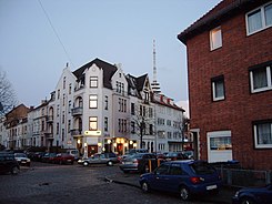
Bremerhavener Strasse
| Bremerhavener Strasse | |
|---|---|
| Street in Bremen | |
| Bremerhavener Strasse at the corner of Loxsteder Strasse | |
| Basic data | |
| city | Bremen |
| district | Walle |
| Cross streets | Wartburgstr., Vegesacker Str., Grenzstrasse, Bassumer Str., Sulinger Str., Elisabethstr., Loxstedter Str., Karl-Peters-Str., Dorumstr., Lübberstedter Str., Helgolander Str., Steffensweg, Bremervörder Str., Beverstedter Str ., Leutweinstr., Waller Ring , Neuenburger Str., An der Reling , Nordstr. , Emder Str., Alte Bremerhavener Str., Getreidestr. |
| use | |
| User groups | Cars, bikes and pedestrians |
| Road design | two and four lane roads |
| Technical specifications | |
| Street length | 2100 meters |
The Bremerhavener Straße is a street in the Bremen district Walle , districts Westend Steffensweg and Walle. It leads in a south-north direction from Wartburgstrasse to Werftstrasse and the Gröpelingen district .
It is divided into the sub-areas
- Wartburgstrasse to Nordstrasse and
- Nordstraße to Werftstraße.
The cross streets were mostly named after towns and cities as Wartburgstraße , Vegesacker Straße, Grenzstraße (1868) after the border between the field marks Utbremen and Walle, Bassumer Straße, Sulinger Straße, Elisabethstraße (1874) after the first name, Loxstedter Straße, Karl-Peters- Street to the colonial politician and Africa researcher Carl Peters , Dorumstrasse , Lübberstedter Strasse, Helgolander Strasse to the island, Steffensweg to Stephan, as the district formerly belonged to the parish of St. Stephani , Bremervörder Strasse, Beverstedter Strasse, Leutweinstrasse after the governor of German South West Africa Theodor Leutwein , Waller Ring , which is connected to the Utbremer Ring and the Osterfeuerberger Ring, Neuenburger Straße, An der Railing after a nautical term, Nordstraße , Emder Straße, Alte Bremerhavener Straße, Getreidestraße (1922) after the grain harbor and the granaries; otherwise see the link to the streets.
history
Bremerhavener Strasse was named after the seaside town of Bremerhaven , to which it leads.
development
The village of Walle was first mentioned in 1139.
At the western end, with the construction of the free port after 1888, the new district of Westend developed. The large jute spinning and weaving mill in Bremen on Nordstrasse employed over 2000 workers around 1895 who lived here. The districts of Steffensweg (today around 4,300 inhabitants) and Westend (today around 6,400 inhabitants) therefore became predominantly densely built-up residential areas. In 1885 parts of the rural community of Walle and in 1902 the other areas were incorporated.
By 1905, a primary school with 16 classes was built on the corner of Steffensweg and Bremerhavener Strasse, in 1913 the secondary school, later the Waller Ring school center as a secondary school, and in 1916 the primary school (double school) and later secondary school at Helgolander Strasse .
During the Second World War , Walle was largely destroyed in 1944. Reconstruction began in 1950. Under the name Westliche Vorstadt , from 1953 to 1955 in Utbremen, Steffensweg and Westend by Gewoba , Bremer Treuhand and Schoß, based on plans by Max Säum , Günther Hafemann , Wilhelm Wortmann , Bernhard Wessel , Werner Hebebrand , Walter Schlempp and Günther Marschall created a larger, more relaxed housing estate.
traffic
The Bremen tram runs through the street today with line 3 in the northern area from Nordstraße.
In Bremen's local traffic, bus routes 26 (Walle ↔ Huckelriede ) and 28 (Walle ↔ Findorff ↔ Wiener Str. ↔ Universität -Nord) depart from Nordstrasse .
Buildings and facilities
There are mainly three to four-story residential buildings on the street.
- Corner of Steffensweg 171: 3-storey. School on Steffensweg in the reform style from 1905 with a red clinker brick facade and two distinctive risalits with rounded tail gables based on plans by building officer Hugo Weber ; today general vocational school; next to it 3-tier modern, red school building
- No. 83 / corner Steffensweg 210: 4-gesch. Brick school center Waller Ring (secondary school) from 1913 with a semicircular gable and the large Bremen coat of arms as well as a roof turret based on plans by building officer Hugo Weber and state building officer Hans Ohnesorge .
Notable buildings and facilities
- Vegesacker Str. 14: 4-sch. Residential and commercial building with a stacked storey and rounded corner formation
- No. 12: 2-sch. Residential house with distinctive corner formation
- No. 36: 2-sch. Residential and commercial building with a round corner tower
- No. 39: 3-sch. Residential and commercial building with emphasized corner formation as a 4-storey. Gables and loggias
- No. 42: 4-sch. Newer residential and commercial building with a pronounced corner formation
- No. 48: 3-sch. Residential and commercial building with side gable risalit , mid- gable and emphasized corner formation through 4-storey. Tower markers
- No. 50: 3-sch. Residential and commercial building of the Neptun pharmacy
- No. 65: 3-sch. House with a gable
- No. 84 to 100: 3-ply preserved houses
- No. 112 to 178: mostly 2-tier Residential houses
- Between Waller Ring and Nordstrasse Allee
- No. 155/157: 1- to 3-layered New buildings from the Arbeiter-Samariter-Bund (ASB) Landesverband Bremen
- Between No. 161 / Emder Straße and Waller Friedhof also called Nordstraße
- Waller Friedhof from 1875 with tombs such as the Knoop mausoleum that are particularly interesting today
- The parallel street from Emder Strasse to Jadestrasse is called Alte Bremerhavener Strasse with the 5-storey. Storage with a gable roof (around Cuxhavener Str. 20) from J. Müller Weser GmbH and the 7-gesch. Building of the BB-Kartbahn (Cuxhavener Str. 31).
literature
- Herbert Black Forest : The Great Bremen Lexicon . 2nd, expanded and updated edition. In two volumes. Edition Temmen, Bremen 2003, ISBN 3-86108-693-X (first edition: 2002, supplementary volume A – Z. 2008, ISBN 978-3-86108-986-5 ).
- Monika Porsch: Bremer Straßenlexikon , complete edition. Schünemann, Bremen 2003, ISBN 3-7961-1850-X .
Individual evidence
Coordinates: 53 ° 6 ′ 5 ″ N , 8 ° 46 ′ 27 ″ E


