Mayor-Ehlers-Platz
| Mayor-Ehlers-Platz | |
|---|---|
| Place in Bremen | |
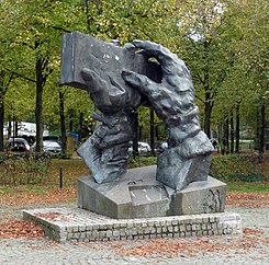
 Sculpture working hands |
|
| Basic data | |
| city | Bremen |
| district | Groepelingen |
| Created | 19th century |
| Newly designed | 1980s |
| Confluent streets | Pastorenweg , Rosenakstrasse, Goosestrasse, Hirschberger Strasse, Dockstrasse, Morgenlandstrasse, |
| use | |
| User groups | Cars, trams, pedestrians, cyclists |
The Bürgermeister-Ehlers-Platz is a square in Bremen in the Gröpelingen district, Lindenhof district, on Pastorenweg .
Streets in the square
The streets on the square were named Pastorenweg after the pastors' way to the Waller Church responsible in the church district , Rosenakstraße 1957 after Rabbi Leopold Rosenak (1868–1923), Goosestraße after the geese (ndt. Goose ) that were probably expelled here, Hirschberger Straße after the town in the former province of Silesia , Dockstraße (unofficially Green Dockstraße ) after the dock of the AG Weser and Morgenlandstraße after the field name ( Morgen = area measure).
history
Surname
The square was named after the politician, SPD senator and Bremen mayor Adolf Ehlers (1898–1978). Ehlers was a member of the Bremen citizenship from 1925 to 1927 , worked in the resistance for the Socialist Workers' Party of Germany (SAPD) from 1933 to 1945 , from August 1945 Senator for Welfare, then for Health and Welfare, and from 1948 to 1963 Senator for the Interior and from 1959 to 1963 Bremen Mayor.
development
In the village of Gröpelingen there was the paved village road and sandy field paths before 1900. The expansion of the ports and the location of Werft AG Weser changed the place extensively. Around 1906 the old Pastorenweg and other streets in the Lindenhof quarter were paved. During the Second World War, great destruction took place in the working-class district in Gröpelingen. From the 1960s / 70s onwards, mostly residential buildings were built around the rectangular square. The closure of AG Weser in 1983 was a decisive event in the district and the sculpture Working Hands from 1987 commemorates it. The course was in 1981 transformed as part of the urban development of the Foundation Cozy city and regional development of the European Union according to the plans of the planning office Team Green Plan and the Green Dockstraße to 1981 and to 2017. Today (2019) the district Lindenhof has about 8000 inhabitants.
traffic
The tram lines 2 (Gröpelingen - Sebaldsbrück) and 10 (Gröpelingen - Hauptbahnhof - Sebaldsbrück) pass by in Bremen on the nearby Gröpelinger Heerstraße .
Buildings and facilities
Two to four-story residential buildings surround the square. Part of the space is u. a. used as a weekly market, part of it as a green space and another part as a parking space with a large number of trees.
- Pastorenweg 177A, on the square: 2-storey, preserved residential and commercial building from around 1910/20 with a mansard roof , a distinctive gable and the small restaurant Pastorendiele .
- Pastorenweg 179: 2nd floor Set back house from around 1900/10 with a crooked hip roof
- Hirschberger Strasse No. 29 to at No. 35/37: 3-storey. Red stone clad houses from the 1980s
- Hirschberger Strasse No. 28 to 30: 3-storey. Houses from? with 4-tier gable
Art objects, memorials
- Bronze sculpture Working Hands from 1987 by the sculptor Bernd Altenstein as a reminder of the working life of the former shipyard workers of the AG Weser, which was closed a year earlier.
swell
- Herbert Black Forest : The Great Bremen Lexicon . 2nd, expanded and updated edition. In two volumes. Edition Temmen, Bremen 2003, ISBN 3-86108-693-X
- Monika Porsch: Bremer Straßenlexikon , complete edition. Schünemann, Bremen 2003, ISBN 3-7961-1850-X .
Individual evidence
Coordinates: 53 ° 6 ′ 47 " N , 8 ° 45 ′ 37" E