Ostercappeln
| coat of arms | Germany map | |
|---|---|---|

|
Coordinates: 52 ° 21 ' N , 8 ° 14' E |
|
| Basic data | ||
| State : | Lower Saxony | |
| County : | Osnabrück | |
| Height : | 73 m above sea level NHN | |
| Area : | 100.19 km 2 | |
| Residents: | 9694 (Dec. 31, 2019) | |
| Population density : | 97 inhabitants per km 2 | |
| Postal code : | 49179 | |
| Primaries : | 05473, 05476 | |
| License plate : | OS , BSB, MEL, WTL | |
| Community key : | 03 4 59 029 | |
| LOCODE : | DE OCP | |
| Community structure: | 3 districts | |
| Address of the municipal administration: |
Gildebrede 1 49179 Ostercappeln |
|
| Website : | ||
| Mayor : | Rainer Ellermann ( CDU ) | |
| Location of the municipality of Ostercappeln in the district of Osnabrück | ||
Ostercappeln is a municipality in the east of the Osnabrück district in Lower Saxony .
geography
Geographical location
Ostercappeln is located in the TERRA.vita nature and geopark at the transition from the northern slope of the Wiehengebirge in the southern part of the municipality of Ostercappeln to the vast moorland in the north of the municipality. The Mittelland Canal crosses the northern parts of the municipality Venne and Schwagstorf.
geology
The diverse landscape is characterized by the Wiehengebirge, Venner Moor and the fields, meadows and mixed forests of the Geest landscape.
Neighboring communities
Ostercappeln borders Bohmte and Bad Essen to the east, Bissendorf to the south, Belm and Bramsche to the west and Neuenkirchen-Vörden ( Vechta district ) to the north .
Community structure
Parts of the municipality and number of inhabitants:
- Ostercappeln (with Haaren, Hitz, Jöstinghausen and Nordhausen, approx. 5,000) - seat of the municipal administration
- Schwagstorf (approx. 2,000)
- Venne (with Broxten, Niewedde and Vorwalde, approx. 3,000)
history
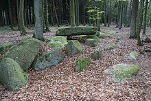
The municipality was already settled in the early days. 5000 years ago numerous megalithic tombs were erected between the Wiehengebirge and the moor , including the Darpvenner stones and the Driehauser stones on the road of megalithic culture .
At the Schnippenburg in the Schwagstorf district there was a fortification during the Iron Age . Recent research has confirmed that the facility was used in the 3rd and 2nd centuries BC. BC, the exact construction time determined by excavations is in the years 278 to 268 BC. The fortifications were completely cremated before their natural decline for reasons unknown until now. Numerous finds prove the importance of the plant in the vicinity of which iron was produced and processed. The fortification is to be seen as the center of a larger settlement area. Various indications indicate that the Schnippenburg was not only used as a settlement and trading center, but was also a place of ritual acts. This is indicated by an area with sacrificial pits that were uncovered in the course of the Schnippenburg excavation project. The research results have been presented in a traveling exhibition since 2007.
Between Bramsche and Ostercappeln is the probable location of the Varus Battle , which is important for European history , in which Germanic troops under the leadership of the Cheruscan prince Arminius defeated three Roman legions .
The district of Venne was first mentioned in 1074, Schwagstorf in 1090 and Ostercappeln in 1198.
On the night of August 1 to August 2, 1982 in Ostercappeln on the Wanne-Eickel-Hamburg railway line, the Nordexpress , which was traveling from Aachen to Copenhagen, collided with an infantry fighting vehicle from the British garrison in Osnabrück . In the accident, the two tank drivers died, the train driver and 21 passengers were injured.
Incorporations
On July 1, 1972, the municipality of Ostercappeln was reorganized through the amalgamation of the municipalities of the Samtgemeinde Ostercappeln (communities Haaren , Hitz-Jöstinghausen, Nordhausen and Ostercappeln) and the Samtgemeinde Venne (communities Broxten, Niewedde and Vorwalde) and the municipality Schwagstorf. On July 1, 1975, a part of the neighboring municipality of Bohmte was added with about 100 inhabitants at that time.
Population development
The following overview shows the population of Ostercappeln in each area and on December 31st.
The figures are updates by the State Office for Statistics and Communication Technology Lower Saxony based on the census of May 25, 1987 .
The data from 1961 (June 6) and 1970 (May 27) are the census results including the places that were incorporated on July 1, 1972. The territorial status on July 1, 1975 applies.
| year | Residents |
|---|---|
| 1961 | 6963 |
| 1970 | 7154 |
| 1987 | 7805 |
| 1990 | 8099 |
| 1995 | 8996 |
| 2000 | 9254 |
| 2005 | 9671 |
| 2010 | 9505 |
| 2011 | 9502 |
| 2015 | 9566 |
| 2015 | 9628 |
| 2018 | 9688 |
politics
Municipal council
The municipality council of the municipality of Ostercappeln consists of 24 councilors. This is the specified number for a municipality with a population between 9,001 and 10,000. The 24 council members are elected by local elections for five years each. The current term of office ends in 2021.
The full-time mayor Rainer Ellermann (CDU) is also entitled to vote in the council of the municipality.
The following table shows the local election results since 1996.
| Council of the municipality of Ostercappeln: election results and municipal councils | |||||||||||||||||||
|---|---|---|---|---|---|---|---|---|---|---|---|---|---|---|---|---|---|---|---|
| CDU | SPD | GREEN | FDP |
Wählerge- Communities |
THE LEFT | total | electoral participation |
||||||||||||
| Electoral term | % |
|
% |
|
% |
|
% |
|
% |
|
% |
|
% |
|
% | ||||
| 1996-2001 | 53.9 | 13 | 31.5 | 8th | 7.0 | 1 | - | - | 7.6 | 1 | - | - | 100 | 23 | 69.4 | ||||
| 2001-2006 | 54.1 | 14th | 36.9 | 10 | 3.4 | 0 | 3.3 | 0 | 2.3 | 0 | - | - | 100 | 24 | 64.8 | ||||
| 2006-2011 | 56.0 | 14th | 38.7 | 9 | - | - | 5.3 | 1 | - | - | - | - | 100 | 24 | 56.6 | ||||
| 2011-2016 | 49.47 | 12 | 33.81 | 8th | 12.82 | 3 | 1.67 | 0 | - | - | 2.24 | 1 | 100 | 24 | 55.83 | ||||
| 2016-2021 | 54.45 | 13 | 27.24 | 6th | 10.62 | 3 | 3.67 | 1 | - | - | 4.03 | 1 | 100 | 24 | 58.06 | ||||
|
Percentages rounded. Sources: State Office for Statistics and Communication Technology Lower Saxony, District Osnabrück. In the case of different information in the sources mentioned, the data from the State Office for Statistics and Communication Technology were used, as they are generally more plausible. |
|||||||||||||||||||
mayor
The full-time mayor of the Ostercappeln community is Rainer Ellermann (CDU). In the last mayoral election on May 25, 2014, he was re-elected as incumbent with 63.5% of the vote. His opponent Johannes Klecker (SPD) received 36.5%. The turnout was 56.5%. Ellermann began his further term of office on November 1, 2014.
- since 2001 Rainer Ellermann (CDU)
- 2001 Günter Schröder (CDU)
- 1984-2001 Heinz Schockmann (CDU)
coat of arms
The coat of arms of the municipality of Ostercappeln shows a black ring, which is reminiscent of the first letter of the place name and the Osnabrücker wheel. The eight red diamonds refer to the former independent municipalities of Haaren, Hitz-Jöstingshausen, Nordhausen, Ostercappeln (joint municipality of Ostercappeln), Broxten, Vorwalde, Niewedde (joint municipality of Venne) and Schwagstorf. The coat of arms was commissioned by the Ostercappeln local council as part of the regional and administrative reform of 1972.
Town twinning
- Bolbec (France)
Culture and sights
music
Venne is considered a folk music center. The International Venner Folk Spring takes place here on Mother's Day weekend in May.
Buildings

The place where today's Catholic Church of St. Lambertus stands in the center of the village is probably the site of the oldest church in Ostercappeln. The hall church was built in the neo-Gothic style in 1873 , the Romanesque tower comes from the previous building from the 14th century, the nave of which was demolished in 1872. The church is furnished with an altar, ambo and tabernacle by the Osnabrück sculptor Walter Mellmann .
Archaeological sights include the Darpvenn megalithic graves, the Iron Age Schnippenburg, the reconstructed Iron Age house in Darpvenne and the ancient battlefield of the Varus Battle between Bramsche and Ostercappeln . The municipality of Ostercappeln has no part in marketing the event, however, as the Kalkriese museum and park are entirely located in the area of the town of Bramsche. In the Großer Moor, not far from the Beinker Inn, what are probably the world's oldest plank paths have been exposed.
The Museum Island in Venne is also worth seeing. Ostercappeln is a stage on the Route of Megalithic Culture and is located on the DiVa Walk .
Sports
You can play golf at the Varus Golf Club. A public 3-hole short course and an 18 -hole course are available there. You can experience nature in the Kronensee leisure park, which has a camping and mobile home park. Water sports are possible in the 40 hectare Kronensee . The signposted cycling and hiking network includes a guidance system with various themed routes. You can fish in the ponds of the Petkenburg.
Stumbling blocks
November 9, 2008 marked the 70th anniversary of the Reichspogromnacht . For this reason, six stumbling blocks by the Cologne artist Gunter Demnig were laid in Ostercappeln on November 11, 2008 . They are intended to commemorate the victims of the National Socialist dictatorship and are moved in front of their former homes or workplaces.
Economy and Infrastructure
traffic
The federal highways federal highways B 51 and B 65 cross the southern part of the municipality Ostercappeln on a common route (Bremer Straße) in an east-west direction. The B 218 crosses the northern parts of the municipality Venne and Schwagstorf from north-west to south-east.
The districts of Venne, Schwagstorf and Ostercappeln have hourly local transport connections to and from Osnabrück (line X275 of VOS-NordOst ) on weekdays . There is also a night bus to and from Osnabrück on Friday and Saturday. Ostercappeln is connected via the N276 line. Venne and Schwagstorf are connected via the N273. There is also an hourly bus connection to Bad Essen, Pr. Oldendorf.
The Osnabrück – Bremen railway line runs through the municipality. However, the train station in the Ostercappeln district is no longer in operation.
The Mittelland Canal runs through the community from west to east.
education
- Primary schools in Ostercappeln, Venne and Schwagstorf
- Secondary and secondary school in Ostercappeln
- music school
Personalities
Sons and daughters of Ostercappeln
- Johann Ernst von Hanxleden (* 1681; † 1732), Jesuit, orientalist and missionary in India
- Franz Hermann Glandorff (* 1687; † 1763), Jesuit, missionary to the Tarahumara in Mexico
- Johannes Heinrich Beckmann (* 1802; † 1878), Bishop of Osnabrück
- Ludwig Windthorst (* 1812 at Gut Caldenhof; † 1891), politician
- Haupt (organ builder) (between 1838 and 1898), family organ builder
- Sabine Bulthaup (* 1962), presenter and actress
- Lisei Caspers (* 1983), documentary filmmaker
- Michael Hohnstedt (* 1988), soccer player
- Moritz von Zeddelmann (* 1988), actor
- Timo Beermann (* 1990), soccer player
- Malte Beermann (* 1992), soccer player
- Bennet Poniewaz (* 1993), volleyball and beach volleyball player
- David Poniewaz (* 1993), volleyball and beach volleyball player
- Moritz Heyer (* 1995), soccer player
Other personalities associated with the city
- Helene Freifrau von Bothmer (1908–1996), German museum curator and US model
- Irmel Weyer (* 1927), German doctor and development worker
literature
- Römisch-Germanisches Zentralmuseum Mainz (ed.): Guide to prehistoric and early historical monuments - Das Osnabrücker Land III , Vol. 44, Verlag Philipp von Zabern, Mainz 1979, ISBN 3-8053-0313-0
- Helmut Schönrock: Ostercappeln . In: Norbert de Lange and Diether Stonjek (eds.): Osnabrück and the Osnabrücker Land - district, cities and municipalities (= cultural region Osnabrück ). tape 22 . Rasch, Bramsche 2004, ISBN 3-89946-035-9 , pp. 241-248 .
Web links
Individual evidence
- ↑ State Office for Statistics Lower Saxony, LSN-Online regional database, Table 12411: Update of the population, as of December 31, 2019 ( help ).
- ↑ traveling exhibition
- ↑ In Ibbenbürener Volkszeitung of August 3, 1982: "Stolen tank got under the express train"
- ↑ a b Federal Statistical Office (ed.): Historical municipality register for the Federal Republic of Germany. Name, border and key number changes in municipalities, counties and administrative districts from May 27, 1970 to December 31, 1982 . W. Kohlhammer GmbH, Stuttgart / Mainz 1983, ISBN 3-17-003263-1 , p. 259 .
- ↑ State Office for Statistics and Communication Technology Lower Saxony, population update
- ^ Lower Saxony Municipal Constitutional Law (NKomVG) in the version of December 17, 2010; Section 46 - Number of MPs , accessed on December 6, 2014.
- ↑ Local elections on September 11, 2016 . In: Ostercappeln.de . Retrieved October 22, 2018.
- ↑ State Office for Statistics and Communication Technology Lower Saxony, Table 5000311
- ↑ Landkreis Osnabrück, official final results of the district election on September 9, 2001 ( Memento from May 25, 2005 in the Internet Archive ) (PDF; 528 kB)
- ^ The local elections for the district of Osnabrück on September 11, 2011 (also includes 2006 results). (PDF 8.0MB p. 52 column "Municipal elections") Osnabrück district, accessed on March 6, 2016 .
- ↑ Individual results of the direct elections on May 25, 2014 in Lower Saxony , accessed on November 8, 2014
- ↑ https://www.noz.de/archiv/vermischtes/artikel/308332/ein-mann-des-ausgleichs-der-die-gemeinde-gepugt-hat Neue Osnabrücker Zeitung on March 3, 2001: "A man of compensation who shaped the community "; accessed on September 28, 2018
- ^ Ostercappeln community - Our community: Ostercappeln village , accessed on November 9, 2014
- ↑ http://eisenzeithaus.de/
- ↑ www.strassedermegalithkultur.de
- ↑ Stolpersteine in Ostercappeln
- ↑ Night bus in and around Osnabrück


