Hilter at the Teutoburg Forest
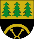
| coat of arms | Germany map | |
|---|---|---|

|
Coordinates: 52 ° 8 ' N , 8 ° 9' E |
|
| Basic data | ||
| State : | Lower Saxony | |
| County : | Osnabrück | |
| Height : | 198 m above sea level NHN | |
| Area : | 52.59 km 2 | |
| Residents: | 10,388 (Dec. 31, 2019) | |
| Population density : | 198 inhabitants per km 2 | |
| Postal code : | 49176 | |
| Primaries : | 05424, 05409 | |
| License plate : | OS , BSB, MEL, WTL | |
| Community key : | 03 4 59 022 | |
| Community structure: | 8 districts | |
| Address of the municipal administration: |
Osnabrücker Strasse 1 49176 Hilter am Teutoburg Forest |
|
| Website : | ||
| Mayor : | Marc Schewski ( CDU ) | |
| Location of the community Hilter in the Teutoburg Forest in the district of Osnabrück | ||

Hilter am Teutoburger Wald (Hilter aTW) is a municipality in the south of the Osnabrück district in Lower Saxony .
origin of the name
There are different interpretations of the name. On the one hand it is said that the basic word ter is included in the name Hilter . This means a tree or bush standing on a root. The old Helderi means something like : the place where lilac trees stand. But there is also the following version: Prefix Hil = Helle ("Hiele") = mountain height, related to Hüls, hils = mountain; tere means green tree (see above). Hilter would then be the "village on the green forest heights".
geography
Geographical location
Hilter is located in the western Teutoburg Forest . The highest point is the Hohnangel (262 m) in the southeast of the municipality. The Limberg , where the Zeppelin LZ 7 "Germany" crashed in 1910, is part of the Hilters area . There, coal was mined in the Hilterberg colliery between 1885 and 1903.
Neighboring communities
Hilter borders in the north on Georgsmarienhütte and Bissendorf , in the east on Melle , in the south on Dissen , Bad Rothenfelde and Bad Laer and in the west on Bad Iburg .
Community structure
Parts of the municipality and number of inhabitants:
- Allendorf (207)
- Borgloh (1782)
- Ebbendorf (731)
- Eppendorf (296)
- Hankenberge (676)
- Hilter (4730) - seat of the municipal administration
- Natrup (included in the population of Hilter)
- Uphöfen (220)
- Wellendorf (1567)
(As of June 20, 2011)
history
The district of Borgloh was first mentioned in a document in 1068; Hilter is first mentioned in 1144.
Incorporations
On April 1, 1937, the community of Natrup-Hilter was incorporated into Hilter. On July 1, 1970, the municipality of Borgloh was created through the merger of the previously independent municipalities of Allendorf, Borgloh-Wellendorf, Ebbendorf, Eppendorf and Uphöfen. On July 1, 1972, this community was incorporated together with Hankenberge into the community of Hilter am Teutoburg Forest.
Population development
The following overview shows the population of Hilter in the respective territories and on December 31st.
The figures are updates by the State Office for Statistics and Communication Technology Lower Saxony based on the census of May 25, 1987 .
The data from 1961 (June 6) and 1970 (May 27) are the census results including the places that were incorporated on July 1, 1972.
| year | Residents |
|---|---|
| 1961 | 7,443 |
| 1970 | 8,275 |
| 1987 | 8,614 |
| 1990 | 8,908 |
| 1995 | 9,640 |
| 2000 | 9,957 |
| 2005 | 10.174 |
| 2010 | 10,228 |
| 2011 | 10,267 |
| 2015 | 10,243 |
| 2017 | 10,383 |
| 2018 | 10,361 |
politics
Municipal council
The parish council currently has 24 members from five parties or groups. In addition, the mayor is a voting member of the council.
The following table shows the local election results since 1996.
| Hilter municipality council: election results and municipal councils | |||||||||||||||||||
|---|---|---|---|---|---|---|---|---|---|---|---|---|---|---|---|---|---|---|---|
| CDU | SPD | Green | FDP | Wählerge- Communities |
Individual applicants |
Others | total | electoral participation |
|||||||||||
| Electoral term | % |
|
% |
|
% |
|
% |
|
% |
|
% |
|
% |
|
% |
|
% | ||
| 1996-2001 | 53.1 | 14th | 33.5 | 9 | 4.7 | 1 | 5.1 | 1 | 3.5 | 0 | - | - | - | - | 100 | 25th | 71.0 | ||
| 2001-2006 | 57.5 | 15th | 33.3 | 8th | 3.7 | 0 | 5.6 | 1 | - | - | - | - | - | - | 100 | 24 | 60.6 | ||
| 2006-2011 | 50.9 | 13 | 34.8 | 8th | 3.7 | 1 | 5.3 | 1 | 2.9 | 1 | 2.3 | 0 | - | - | 100 | 24 | 61.8 | ||
| 2011-2016 | 50.7 | 13 | 31.7 | 7th | 9.0 | 2 | 3.7 | 1 | 4.7 | 1 | - | - | - | - | 100 | 24 | 53.4 | ||
| 2016-2021 | 55.44 | 13 | 29.96 | 7th | 7.68 | 2 | - | - | 6.93 | 2 | - | - | - | - | 24 | 56.31 | |||
|
Percentages rounded. Sources: State Office for Statistics and Communication Technology Lower Saxony, District Osnabrück, Municipality Hilter . In the case of different information in the sources mentioned, the data from the State Office for Statistics and Communication Technology were used, as they are generally more plausible. |
|||||||||||||||||||
mayor
| Period | mayor | choice |
|---|---|---|
| until 10.2006 | Hans Bernhard Bussmann (CDU) | He had been the full-time mayor since May 1997. |
| 11.2006-03.2013 | Wilhelm Wellinghaus (independent) | He emerged victorious from a runoff election on September 24, 2006. |
| since 04.2013 | Marc Schewski (CDU) | He emerged victorious in the mayoral election on January 20, 2013. |
Culture and sights
Buildings
To the west of the Borgloh district is a water tower and observation tower built in 1961 .
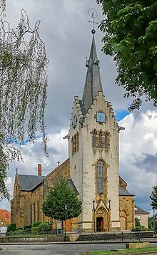
The Church of St. John the Baptist is in the Hilter district . The parish church of the Ev.-luth. The parish was built from 1857 to 1859 in neo-Gothic style based on plans by the architect Conrad Wilhelm Hase .
Regular events
Two weeks after Easter, the spring concert of the Borgloh brass orchestra takes place every year.
Every year in August the MSC Osnabrück hosts the Hilter-Borgloh on Uphöfener Mountain Osnabrücker hillclimb .
The ocher market takes place every year in October. Then the through-town is closed and reserved for pedestrians as an ocher mile . Local groups such as the Hilter volunteer fire brigade , the men's choir and the nationally known Devil's Quartet are represented here.
Infrastructure and economy
economy

In the early 18th century, hard coal mining was the most important line of business in Hilter. He was sponsored by the Osnabrück Prince-Bishop Ernst August II . In addition Hilter was Hilter ocher mined. In 1903 Walter Rau, who bought the local Meierhof , founded the Walter Rau Lebensmittelwerke . The food industry company was taken over by the US-American Bunge group in February 2008 . Agriculture still plays an important role in Hilter; 56.3 percent of the total area of the municipality is used for agriculture.
traffic
Hilter is connected to the trunk road network via the federal highway A 33 , which crosses the local area in a north-south direction . State road 756 continues through the village. (Former federal road 68)
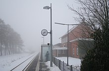
The Hilter stop and Wellendorf train station are on the Osnabrück – Bielefeld line ( KBS 402 ), on which the “ Haller Willem ” RB 75 regional train runs every hour . There was also a Hankenberge train stop (until the 1950s a train station, later a stop within the meaning of the Railway Operating Regulations ), which was very much appreciated by hikers because it was on the ridge of the Teutoburg Forest and therefore was one of the highest train stations in northwest Germany. Local rail passenger transport is carried out by NordWestBahn , which uses Talent diesel multiple units.
A regional bus line connects Hilter with Dissen, Bad Rothenfelde , Georgsmarienhütte and Osnabrück.
The tariff of the Verkehrsgemeinschaft Osnabrück (VOS) applies to bus transport in the Osnabrück district . The VOS-Plus network tariff can be used in the “Haller Willem” and a transitional tariff to the Westphalian tariff (limited to the “TeutoOWL” network of OWL Verkehr GmbH to Bielefeld) can be used in the direction of Bielefeld .
Personalities
Sons and daughters of the church
- Heinrich Struck (1825–1902), personal physician to Otto von Bismarck
- Karl Ahrens (1924–2015), politician (SPD), Member of the Bundestag
- Irmgard Vogelsang (1946–2019), politician (CDU), MdL
- Dirk Konerding (* 1969), footballer
People connected to the community
- Wolfgang Seegrün (* 1934), historian and Roman Catholic theologian; 1966 pastor in Hilter
- Wurst-Achim (* 1963), barker
- Robin Schulz (* 1987), musician
Web links
Individual evidence
- ↑ State Office for Statistics Lower Saxony, LSN-Online regional database, Table 12411: Update of the population, as of December 31, 2019 ( help ).
- ↑ First mention of Borgloh and Hilter
- ↑ a b Federal Statistical Office (ed.): Historical municipality register for the Federal Republic of Germany. Name, border and key number changes in municipalities, counties and administrative districts from May 27, 1970 to December 31, 1982 . W. Kohlhammer GmbH, Stuttgart / Mainz 1983, ISBN 3-17-003263-1 , p. 258 and 259 .
- ↑ State Office for Statistics and Communication Technology Lower Saxony, population update ( page no longer available , search in web archives ) Info: The link was automatically marked as defective. Please check the link according to the instructions and then remove this notice.
- ↑ State Office for Statistics and Communication Technology Lower Saxony, Table 5000311
- ↑ Landkreis Osnabrück, official final results of the district election on September 9, 2001 ( Memento from May 25, 2005 in the Internet Archive ) (PDF; 528 kB)
- ^ The local elections for the district of Osnabrück on September 11, 2011 (also includes 2006 results). (PDF 8.0MB p. 70 column "Municipal elections") Osnabrück district, accessed on March 6, 2016 .
- ↑ Quick report on municipal elections on September 11, 2016. Hilter municipality, accessed on March 26, 2019 .
- ↑ The water tower on the website of the Heimatverein der Samtgemeinde Borgloh e. V.
- ^ Prince-Bishop Ernst August II promoted mining
- ↑ Query of course book route 402 at Deutsche Bahn.


