
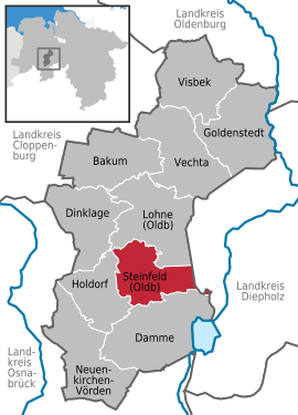
Steinfeld (Oldenburg)
| coat of arms | Germany map | |
|---|---|---|

|
Coordinates: 52 ° 35 ' N , 8 ° 13' E |
|
| Basic data | ||
| State : | Lower Saxony | |
| County : | Vechta | |
| Height : | 47 m above sea level NHN | |
| Area : | 59.83 km 2 | |
| Residents: | 10,240 (Dec. 31, 2019) | |
| Population density : | 171 inhabitants per km 2 | |
| Postal code : | 49439 | |
| Area code : | 05492 | |
| License plate : | VEC | |
| Community key : | 03 4 60 008 | |
| Community structure: | 10 districts | |
| Address of the municipal administration: |
Am Rathausplatz 13 49439 Steinfeld |
|
| Website : | ||
| Mayoress : | Manuela Honkomp ( independent ) | |
| Location of the municipality of Steinfeld in the district of Vechta | ||
 _in_VEC.svg) |
||

Steinfeld (Oldenburg) is a municipality in the district of Vechta in Lower Saxony . The Vechta region is known as a horse region, Steinfeld is also known beyond the regional borders thanks to its district Mühlen for equestrian activities.
geography
Geographical location
Steinfeld is located in the Oldenburger Münsterland between Osnabrück and Bremen. The watershed between the Hase and thus the Ems and the Hunte and thus the Weser runs over the foothills of the Dammer Mountains , which run through Steinfeld from south to north . In the southeast the ridge merges into the Dümmerniederung . In the northeast of Steinfeld is the Steinfelder Moor , a large, connected nature reserve that extends to Kroge-Ehrendorf in the north . The direct neighboring communities and cities include Damme , Holdorf , Lohne and Diepholz .
Community structure
Steinfeld has several districts:
- Baring
- Brokamp-Wieferich
- Düpe
- Harpendorf
- Holthausen
- Muds
- Mills
- Ondrup
- Schemde
- Steinfeld-South
- Steinfeld-Mitte
climate
Temperate maritime climate influenced by humid northwest winds from the North Sea. On a long-term average, the air temperature in Steinfeld reaches 8.5 ° C – 9.0 ° C and about 700 mm of precipitation falls. Between May and August, an average of 20-25 summer days can be expected.
religion
The community's population is predominantly Catholic . The Catholic parish church of St. John and the Protestant Church of the Resurrection are located in the community . The Catholic St. Bonaventure Church is located in the village of Mühlen.
politics

_Ortsmitte_Kirche.jpg)
Municipal council
The council of the municipality of Steinfeld consists of 22 councilors. This is the specified number for a municipality with a population between 9001 and 10,000 inhabitants. The 22 council members are elected for five years each by local elections. The current term of office began on November 1, 2016 and ends on October 31, 2021.
The full-time mayor Manuela Honkomp is also entitled to vote in the municipal council.
The last local election on September 11, 2016 resulted in the following:
| Political party | Proportional votes | Number of seats | Change voices | Change seats |
|---|---|---|---|---|
| CDU | 68.03% | 15th | −3.49% | −1 |
| UWG | 24.04% | 5 | + 2.95% | 0 |
| SPD | 7.91% | 1 | +0.53% | 0 |
The turnout in the 2016 local elections was 55.84%, slightly above the Lower Saxony average of 55.5%. For comparison - in the previous municipal election on September 11, 2011, the turnout was 54.58%.
mayor
The non-party candidate Manuela Honkomp won the runoff election on September 24, 2006 against the CDU challenger Udo Koschate with 54.79% of the votes cast. This makes Manuela Honkomp the first woman in the office of full-time mayor in the Vechta district. In the last mayoral election on May 25, 2014, she was re-elected with 73.17% against two opposing candidates. The turnout was 55.59%. Honkomp began her further term on November 1, 2014.
coat of arms
The coat of arms of the municipality of Steinfeld shows:
- 1st field, top left (heraldic right): the old count's coat of arms (2 red bars on a yellow background).
- 2nd field, top right (heraldic left): St. John the Baptist, the patron saint of the church in Steinfeld, behind his head lies the sword as a sign of martyrdom.
- 3rd field, bottom left (heraldic right): five stylized stones to echo the name Steinfeld, in the colored heraldic shield the white stones will be on a green background.
- 4th field, bottom right (heraldic left): Delmenhorster Cross (yellow on a blue background).
Fields 2 and 3 contain the peculiarities of the municipality of Steinfeld (Oldb), fields 1 and 4 indicate that it belonged to the former Grand Duchy of Oldenburg.
Town twinning
A town partnership exists with the Polish city of Jastrowie .
Culture and sights
In 2004 the “Steinfeld Horse Road” campaign was initiated: 75 brightly painted horse models pointed out the sights of the Steinfeld community. In 2006, 14 horses were part of the cultural program of the soccer world championship in the city of Hanover. Ten models painted with the jerseys of the national soccer teams playing in Hanover stood at the Dicken Stein in Steinfeld in 2007. Today, individual models of the “horse road” can be found scattered throughout the municipality, but also partially in the neighboring municipalities of Steinfeld.

2004: Opening of the "Steinfelder Horse Street"

"Thick stone"
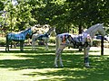
2005: Original horse models placed at the “Dicken Stein”

2007: Horse models returned from Hanover from the 2006 World Cup


Museums
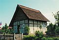
The former seafaring school in the Steinfeld district of Mühlen
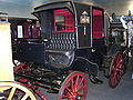
One of many carriages in the Steinfelder Carriage Museum

The historical "tannery" in which the local archive is located


Parks


The "Dammer Mountains" extend to the south of the municipality. The landscape, richly blessed by nature, is one of the most beautiful in the Oldenburger Münsterland. In this wooded area with its miles of hiking trails you can find peace and relaxation. The “Schemder Bergmark” recreation center offers further leisure opportunities.
brewery
Steinfeld owned his own brewery from the end of 2007 to the end of 2012, in which the "Lüken Topp" beer was brewed.
Regular events
The New Year's Eve run takes place in Mühlen on New Year's Eve.
The three-day Steinfelder Schützenfest takes place on the first weekend in July, the climax of which is the proclamation of the new king on Monday evening around 7 p.m. Approx. 1000 shooters take part in the parades.
traffic
Steinfeld is close to the A 1 motorway , Holdorf junction, and the B 214 federal road . The Delmenhorst – Hesepe railway also runs through Steinfeld. The trains of the NordWestBahn run every hour as RB 58 from Osnabrück to Bremen. Due to the traffic situation and the good infrastructure, Steinfeld is characterized by a high demand for commercial and industrial space. The last few decades have been characterized by intensive workplace development and settlement.
economy
Steinfeld is located in the southern Oldenburger Münsterland, which developed into a boom region in Lower Saxony in the 1990s. Since 1994 the gross domestic product has grown by 62%, the value added of services by 63%. The industrial turnover has increased by 48% since 1997 to 6.5 billion euros, the export turnover by 137%.
The unemployment rate in Oldenburger Münsterland of a good 3.5% (Steinfeld approx. 4%) is one of the lowest, and the home ownership rate of over 80% is one of the highest in Germany. The density of single-family houses is also one of the highest in the whole of Germany.
The total area of all industrial and commercial areas in Steinfeld is approx. 100 hectares. The community has a rural character, which means that the agricultural sector is given special attention. Various slaughterhouses are located in Steinfeld. The plastics processing industry is represented in the entire municipality by medium-sized and international companies.
media
- Magazine of the sports club "Falken-Echo"
education
In the church there is
- four kindergartens
- two primary schools,
- a high school
Buildings


- 134 meter high telecommunications tower of Deutsche Telekom AG at 52 ° 33'30 "N 8 ° 12'38" E
- Military telecommunications tower on the Signalberg at 52 ° 33'10 "N 8 ° 12'56" E
- Catholic parish church St. Johannes Baptist , 1897–1899 (architect: Wilhelm Rincklake , Münster; construction work: August Rincklake , Münster; cycle of colored glass windows from the glass painting workshop of Dr. Heinrich Oidtmann , Linnich).
- Evangelical Parish Church of the Resurrection
- Pöhlking watermill
- Watermill Schemde
- Meyer watermill in mills
Tourism routes
The holiday routes “ pit stop route ” and “ Niedersächsische Mühlenstrasse ” run through the Steinfeld area . The Pickerweg , which is part of the Jakobsweg network , also runs through Steinfeld . This makes the Pickerweg part of the oldest European cultural route .
Shooting club
In addition to other cultural associations, there are three rifle clubs in Steinfeld (Schützenverein Steinfeld from 1845 eV, Schützenverein Mühlen from 1919 eV and the Schützenverein Harpendorf-Düpe from 1965 eV). The Schützenverein Steinfeld von 1845 eV celebrates its annual traditional shooting festival on the 1st Sunday in July.
Personalities
- Andreas Bergmann (born June 18, 1959 in Steinfeld), football coach; u. a. FC St. Pauli , Hannover 96 and VfL Bochum
- Rainer-Maria Halbedel b. Ruhnke (born December 15, 1948 in Steinfeld) cook in Bad Godesberg
- Josef von der Heide (born July 19, 1903 in Ondrup; † April 26, 1985 in Steinfeld), politician ( center )
- Clemens-August Krapp (born July 23, 1938 in Steinfeld), politician and entrepreneur in the hardware trade; Member of the Lower Landtag from 1974 to 1994 ( CDU ); District Administrator of the Vechta district from 1972 to 2001
- Otto Krapp (born May 19, 1903 in Steinfeld; † October 9, 1996), politician, lawyer and notary, public prosecutor, member of the Lower Parliament of the 1st and 2nd electoral periods until December 8, 1953 (center), June 7, 1950 to October 12, 1950: Lower Saxony Minister for Special Tasks, August 21, 1950 to December 1, 1953: Lower Saxony Minister of Justice
- Jürgen Krogmann (born November 14, 1963 in Steinfeld), journalist, politician ( SPD ), member of the Lower Saxony state parliament for the 16th electoral period, Lord Mayor of Oldenburg (Oldb) since 2014
- Carl Heinrich Nieberding (born October 1, 1779 in Steinfeld, † April 11, 1851 in Lohne (Oldenburg) ), politician and historian
- Mareike Nieberding (* 1987 in Steinfeld), journalist
- Engelbert Rehling (born June 29, 1906 in Düpe, † November 25, 1976 in Aachen ), Catholic religious chaplain ( OMI ), who was imprisoned in Dachau concentration camp in 1941 because of his critical attitude towards the Nazi regime
- Michael Ruhnke (born May 19, 1958 in Steinfeld), author and journalist
- Alwin Schockemöhle (born May 29, 1937 in Meppen ), former show jumper ; Olympic champion in Rome in 1960 and Olympic champion in Montreal in 1976
- Paul Schockemöhle (born March 22, 1945 in Steinfeld), former show jumper (three-time European champion) and entrepreneur.
- Werner Schockemöhle (born November 2, 1939 - February 1, 2000), entrepreneur, horse breeder, lawyer and notary
- Theo Schönhöft (born May 9, 1932 - † July 26, 1976), football player
- Anton Themann (born September 18, 1886 - † April 4, 1965 in Refrath ), politician (CDU)
Individual evidence
- ↑ State Office for Statistics Lower Saxony, LSN-Online regional database, Table 12411: Update of the population, as of December 31, 2019 ( help ).
- ↑ www.steinfeld.de ( Memento of the original from October 16, 2016 in the Internet Archive ) Info: The archive link was inserted automatically and has not yet been checked. Please check the original and archive link according to the instructions and then remove this notice. , Riding and driving club
- ↑ Climatological term for days on which the maximum temperature exceeds 25 ° C
- ^ Lower Saxony Municipal Constitutional Law (NKomVG) in the version of December 17, 2010; Section 46 - Number of MPs , accessed on January 11, 2017.
- ↑ a b c Municipality of Steinfeld - overall results of the 2016 municipal council election , accessed on January 11, 2017
- ↑ The CDU gets the most votes nationwide. September 12, 2016. Retrieved January 11, 2017 .
- ↑ Steinfeld: Mayor election 2014 - preliminary overall result of mayor election 2014 May 25, 2014 , accessed on August 31, 2014
- ↑ St. John the Baptist. Historicism stained glass. Steinfeld in Oldenburg. Festschrift Hundred Years of the Catholic Parish Church Steinfeld November 16, 1899-16. Nov. 1999, Ed .: Franz Ortmann, Druckhaus Friedr. Schmücker, Löningen 1999, ISBN 3-9806575-2-3 .
- ↑ Mühlenstraße working group in the Mühlenvereinigung Niedersachsen - Bremen eV: Wassermühle Pöhlking, Steinfeld
- ^ Mühlenstrasse working group in the Mühlenvereinigung Niedersachsen - Bremen eV: Wassermühle Schemde / Steinfeld
- ↑ Mühlenstrasse working group in the Mühlenvereinigung Niedersachsen - Bremen eV: Wassermühle Meyer in Mühlen / Steinfeld
- ↑ Map of the pit stop route on archive.org (2.2 MB PDF) ( Memento from October 28, 2007 in the Internet Archive ), accessed on October 18, 2013
- ↑ Steinfelder stations of the pit stop route http://www.boxenstopp-route.de/index.php?pageId=3&treg=2&preg=21
- ↑ Map of the mills in the Vechta district http://www.niedersaechsische-muehlenstrasse.de/index.php?id=322
- ↑ Map of the Way of St. James http://www.via-regia.org/kulturstrasse/karte.php
Web links
Bakum | Dam | Dinklage | Goldenstedt | Holdorf | Lohne (Oldenburg) | Neuenkirchen-Vörden | Steinfeld (Oldenburg) | Vechta | Visbek