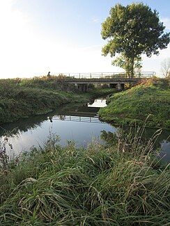
Dinklager Mühlenbach
| Dinklager Mühlenbach | ||
|
The Barkhoffsbach flows into the Dinklager Mühlenbach immediately east of the A 1 |
||
| Data | ||
| location | In Lower Saxony ( Vechta district ) | |
| River system | Ems | |
| Drain over | Camp Hase → Hase → Ems → North Sea | |
| source | in the area of the municipality of Holdorf 52 ° 36 ′ 14 ″ N , 8 ° 6 ′ 52 ″ E |
|
| muzzle | north of Dinklage confluence with the floodplain to Lager Hase Coordinates: 52 ° 42 ′ 4 ″ N , 8 ° 4 ′ 13 ″ E 52 ° 42 ′ 4 ″ N , 8 ° 4 ′ 13 ″ E
|
|
| Small towns | Dinklage | |
| Communities | Holdorf | |
Dinklager Mühlebach is the name of a stream that in the field of community Holdorf springs, the city Dinklage flows from south to north and to the north of the city of Aue for Lager Hase combined. The brook runs exclusively in the area of the Vechta district and belongs to the water system of the Hase and thus the Ems . The catchment area of the Dinklager Mühlenbach and its tributaries covers 136.31 km².
nomenclature
The nomenclature of official bodies is decisive for the use of language in this article, in particular the Lower Saxony State Office for Water Management, Coastal and Nature Conservation and the Vechta district. Deviating from this, the 3.2 km long section of the Dinklager Mühlenbach between the confluence of the Hopener Mühlenbach and the junction with the floodplain is sometimes considered to be the upper reaches of the Hase camp. Another deviation from the official naming is to assign the lower course of the Dinkel to the Dinklager Mühlenbach and at the same time to allow the Jansbach to flow up to km 5.5 (where, according to official usage, the Dinkel flows into the Dinklager Mühlenbach ).
course
The sources of the Dinklager Mühlenbach are not far east of the federal motorway 1 north of the center of Holdorf on the foothills of the Dammer Mountains . From the beginning, the stream runs roughly parallel to the motorway in a northerly direction and forms the border between the municipality of Holdorf in the east and the town of Dinklage in the west for long stretches. It takes the Sievenbach, the Kreuzbach and the Barkhoffsbach (at km 10.9) from the right. At its confluence, the Dinklager Mühlenbach is pivoted to the west and (at km 10.8) passed under the motorway. It then flows north and shortly afterwards in a north-westerly direction and takes the Trenkampsbach (at km 6.9) - also called Mühl (en) er Mühlenbach - from the right and left (at km 5.7) the Brookbach. Until it joins the floodplain, the stream then maintains its northward direction of flow. Shortly after the Brookbach, coming from the right at 5.5 km, the Dinkel flows into the Dinklager Mühlenbach . It follows, coming from the right, (at km 4.1) the Plaggenriehe and (at km 3.2) the Hopener Mühlenbach, at km 1.9 the Bünner Bach from the left and the Höner Markgraben from the right, before the brook the northern city limits of Dinklage and thus the border to the district of Cloppenburg reached.
According to the official nomenclature, the Jansbach is a left tributary of the Barkhoffsbach.
ecology
In their 2004 pilot report, the Weser-Ems district government and the NLWKN found out about the sandy tributaries to the central Hase that the left tributaries of the Hase and the waters that do not flow to it from the district of Vechta are the "structurally better waters". The waters of Bakumer Bach, Dinklager Mühlenbach , Aue and Bokerner Bach flowing from the district of Vechta are rated worse because of their “high quality losses”.
For the area northwest of Autobahn 1, floodplains of the Dinklager Mühlenbach were officially established.
Individual evidence
- ^ Lower Saxony Ministry for Climate, Energy and Environmental Protection: Area directory for the Lower Saxony hydrographic map . P. 16
- ↑ z. B. Geoview: Camp Bunny
- ↑ The kilometers are opposite to the direction of flow of the Dinklager Mühlenbach, starting at its confluence with the floodplain
- ↑ This assignment can be found on the printed maps issued by the ADAC .
- ↑ Dinklage fishing association Dinklager Mühlenbach with tributaries
- ↑ Bezirksregierung Weser-Ems / NLWKN: Inventory of the implementation of the EU Water Framework Directive. Surface waters - Hase processing area - . 2004. p. 20
- ↑ cf. also Lower Saxony State Agency for Water Management, Coastal Protection and Nature Conservation (NLWKN) Meppen office: International management plan according to Article 13 of the Water Framework Directive for the Ems river basin district 2010–2015 . 2009. pp. 189 and 229f.
- ↑ District of Vechta: floodplain of the camps Hase and the Dinklager Mühlenbach as well as the district of Cloppenburg: [1] , [2] , [3] and [4]
