
Fladder Canal
| Fladder Canal | ||
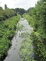
 Fladder Canal south of the Lüsche polder |
||
| Data | ||
| location | In Lower Saxony (districts of Vechta and Cloppenburg ) | |
| River system | Ems | |
| Drain over | Camp Hase → Hase → Ems → North Sea | |
| source | Confluence of Vechtaer Moorbach and Spredaer Bach 52 ° 43 ′ 14 ″ N , 8 ° 14 ′ 28 ″ E |
|
| muzzle |
Lager Bunny Coordinates: 52 ° 42 ′ 18 " N , 8 ° 1 ′ 11" E 52 ° 42 ′ 18 " N , 8 ° 1 ′ 11" E
|
|
| length | 15.3 km | |
| Flowing lakes | Polder Lüsche | |
| Communities | Bakum , Essen / Oldenburg | |
Fladder Canal is the name of a 15.3 km long artificial body of water in Lower Saxony , which runs below the confluence of the Vechtaer Moorbach and the Spredaer Bach in a westerly direction and flows into the Hase camp in Osteressen . The name Fladderkanal refers to the "Fladder-Niederung", a natural area in the north of the Quakenbrücker basin . The Low German word "Fladder" (or also "Fledder") denotes swampy grassland.
course
To the west of Vechta , the Vechtaer Moorbach and the Spredaer Bach flow together. Today the Fladder Canal runs almost in a straight line in a westerly direction through the area of the municipality of Bakum in the district of Vechta and prevents the surface water from feeding the former lower reaches of the streams south of it with water. To the north of the Fladder Canal, the Bruchbach was diverted in a westerly direction, so that it no longer flows southeast of Hausstette into the Carumer Bach, but north of the Lüsche Polder , located immediately north of the Fladder Canal (between km 4.9 and 5.5), into the Steinbäke. This feeds the Fladder Canal southwest of the polder (at km 4.4) . After a slight turn towards the west- south- west, the Fladder Canal takes on the Bentbach (at 2.8 km) and then the Weißevehnbach (at 1.0 km) from the right. Shortly after the confluence of the Bentbach, the canal crosses the border with the Cloppenburg district and reaches the area of the Essen / Oldenburg community
nature

Fladder Canal in the Daren Forest
Fladder Canal near Rhaden

Fladder Canal at Gut Lage


In 2000, the Lower Saxony State Agency for Water Management and Coastal Protection (NLWK) stated: The Fladder Canal has been continuously straightened because it was artificially created. The banks were expanded to a standard profile that has now partially decayed. A grove of trees typical of a water body is missing even where the stream runs through the forest. Due to a deep deepening, the water is cut off from its floodplain, where mainly arable farming is carried out. The Fladder Canal is diked below the motorway to the Lüsche polder. Increasing silting up of the sole also leads to a further deterioration in the structural quality. The biological patency in the lower reaches of the Fladder Canal is interrupted several times.
history
Until the 1920s, the water from the Vechtaer Moorbach and the Spredaer Bach, meandering around today's Fladder Canal , moved towards the floodplain , which absorbed the water and, likewise strongly meandering, from km 12.0 a little south of today's Fladder Canal the camp Hase flowed towards it, which it met above the eponymous estate of Lage. Today, just south of the Fladder Canal near Südholte, the former upper course of the floodplain is blocked off. The Carumer Bach has also lost its upper course in this way (at km 8.7).
Web links
- District of Vechta: Floodplains of the Fladder Canal. 4 cards ( [1] , [2] , [3] and [4] )
- Heimatbund for the Oldenburger Münsterland: Bakum - excerpt from LeCoq's map from 1805 and Essen - excerpt from LeCoq's map from 1805
Individual evidence
- ^ Matthias Rickling: Osnabrück from A to Z Aschendorff Verlag 2007, ISBN 3-402-06554-1 . Keyword: Fledder (district)
- ↑ The kilometers are set up the canal, starting at the mouth of the Fladder Canal in the Hase camp. It follows the maps of the Vechta district (see web links)
- ↑ Dinklage fishing association: Fladder Canal
- ↑ a b Lower Saxony State Office for Water Management and Coastal Protection (NLWKN), Cloppenburg office: Regional structural quality report of the Cloppenburg NLWK office, section Fladder Canal / Vechtaer Moorbach (GKZ 3644) . 2000, p. 33