
Vechtaer Moorbach
|
Vechtaer Moorbach also: Alte Bäke (upper course), exclusively: Fladder Canal (today's lower course) or Aue (historical lower course) |
||
 |
||
| Data | ||
| Water code | DE : 36442 | |
| location | District of Vechta , Lower Saxony ( Germany ) | |
| River system | Ems | |
| Drain over | Lager Hase → Große Hase → Hase → Ems → North Sea | |
| origin | at Tiefen Schlatt near Hagstedt 52 ° 49 ′ 1 ″ N , 8 ° 16 ′ 21 ″ E |
|
| muzzle | as the Fladder Canal near Addrup in the Hase camp coordinates: 52 ° 42 ′ 18 ″ N , 8 ° 1 ′ 12 ″ E 52 ° 42 ′ 18 ″ N , 8 ° 1 ′ 12 ″ E
|
|
| Left tributaries | Lutter Mühlenbach , Hasbach , Schlochter Bäke | |
| Right tributaries | Hagstedter Bäke , Neue Bäke , Spredaer Bach , Bakumer Bach , Steinbäke | |
| Medium-sized cities | Vechta | |
The Vechtaer Moorbach is a 22 km long loess - loam shaped lowland brook and flows through the district of Vechta in the eastern catchment area of the Ems .
course
Today's course
The headwaters of the Vechta Moorbach lies directly on the Weser-Ems watershed . Its main source stream rises on the state road 873 northwest of the Tiefen Schlatt , in the northeast of the Visbeker peasantry Hagstedt , and flows from there in a south-southeast direction. Before crossing under the 334 district road, the Vechtaer Moorbach flows into the Hagstedter Bäke from the right. Before Astrup , the Vechtaer Moorbach takes its second stream from the left, coming from the corridors Hundenschlatt and Fahrenfeldskämpe to the north. In the further course the Vechtaer Moorbach forms the border between the city of Vechta (district Holzhausen ) and the community Goldenstedt (district Lutten ). Here, the Vechtaer Moorbach flows first from the east towards the Lutter Mühlenbach, the Hasbach and the Schlochter Bäke , and after its change of direction to the west, towards Vechta, the Neue Bäke from the north.
To the east of the Vechta Moorbach there are large raised bog areas , the north-western part of which is drained via the stream. In Telbrake the Vechtaer Moorbach changes direction and flows from there to the west.
The brook crosses the city center of Vechta. It splits behind the water mill into a northern and a southern arm. The southern arm flows south of the Marienhospital directly to the west, initially parallel to the Contrescarpe and then accompanies the Bokerner Damm to the western city limits of Vechta. The northern arm, called Nepomukgraben, flows north past the district court, the provost church of St. George and the Kaponier into the grounds of the citadel park . Its western moat flows into the south arm southwest of the cemetery. The last part of the Nepomuk trench was diverted in 1935 when the airfield was built; previously it had flowed on to the west via what would later be the airfield. A third arm of the moor brook, which ran from the Vechta watermill in the direction of Bremer Tor and from there flowed into the citadel area, no longer exists today.
In the municipality of Bakum the watercourse changes its name to the Fladder Canal after the confluence of the Spreda Brook in front of Gut Daren . After inflow of coming out Bakum the north Bakumer Bach immediately before passing under the Bundesautobahn 1 of Fladderkanal takes west of the Lüsche polder the coming from the northeast Steinbäke and opens in the further course in the bearing rabbit , which in turn the internal Delta the Hase , a right tributary the Ems , flows towards it.

Vechtaer Moorbach in Astrup

Vechtaer Moorbach, viewed from the Pickerweg

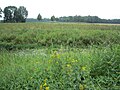
Moorbachaue at high water on the hiking trail from Immuntun to Füchtel

Well system above the cased Nepomuk ditch between Europaplatz and Kaponier

Vechtaer Moorbach during the Vechtaer Lichtertage 2015 directly above the Kaponier

Vechtaer Moorbach immediately below the Kaponiers

Vechtaer Moorbach at the sewage treatment plant
Moorbachaue in the southeast of Bakum


Previous history
Up until the 1920s, the floodplain and not the Fladder Canal formed the continuation of the Vechta Moorbach and the Spreda Bach. The floodplain, artificially shortened by the separation from the Fladder Canal, still pours a few kilometers further southeast from the confluence of the Fladder Canal in the Hase camp.
According to Carl Heinrich Nieberding , the “Vechtaer Bach” flowed until Easter in the last quarter of the 18th century . Already there he came across the "Osnabrücksche Haase", which was relocated to the west before 1800 and was directed via a "new Haase Canal" (i.e. the New Hase or the Essen Canal ). As a result, the "Vechtaer Bach" was extended to the current mouth of the Hase camp west of Essen. In Nieberding's linguistic usage, both the Aue and the Lager Hase are sections of the “Vechtaer Bach”.
Appearance
In the upper reaches, in the area between Astrup and Holtrup , the Vechtaer Moorbach initially meanders through a primeval alluvial forest. Although the brook has also been partially straightened here, you will find a much greater structural diversity here than in other smaller bodies of water in the North German Plain , as there is no intensive maintenance of the body of water. Here you can also find longer, contiguous strips of wood on the banks.
In the further course, the extent of the straightening of the Vechtaer Moorbach increases. For the most part, there are no riparian trees and edge strips as a buffer zone against the mostly agricultural use of the floodplain. The course of the brook was also greatly changed below Vechta, as can be easily seen from the name Fladder Canal. The channel has a few and only gentle turns and is west of Federal Highway 1 on both sides of dikes .
The ecological condition of the Vechtaer Moorbach was rated “bad” in 2009 by the Lower Saxony State Agency for Water Management, Coastal and Nature Conservation (NLWKN).
Historical meaning
At no point between the Hunte and the Ems is the distance between the higher areas of the Ems-Hunte-Geest (here: the Cloppenburger Geest ) and the heights to the south (here: the foothills of the Dammer Mountains ) as low as there where the Vechtaer Moorbach turns west. Since trade routes through the North German lowlands were laid as high as possible in the Middle Ages, the idea was to use the ford over the Vechtaer Moorbach near today's Vechta and to establish a long-distance trade route, a fortification and a town there. In the early Middle Ages, the northern arm of the Vechtaer Moor Bach formed the boundary between the Saxon districts Dersagau and Lerigau .
The long-distance trade route " Rheinische Straße " from Bremen to Dortmund was first mentioned in a document in 851. The first castle in Vechta was built around 1080. After the fire in the city and Vechta Castle in 1684, it was abandoned and replaced by the citadel. The castle is to be reconstructed as Castrum Vechtense between 2012 and 2022 in the Citadel Park Vechta.
Criticism of the nomenclature
The Heimatverein Oythe criticizes that "since time immemorial" the course of the Moorbach begins where the Alte Bäke and the Schlochter Bäke from Lutten meet . The correct name for the upper reaches of the Vechta Moorbach is thus Alte Bäke .
literature
- Heinz Höppner: The Moorbachtal near Vechta . In: Yearbook for the Oldenburger Münsterland 1980 . Vechta 1979, pp. 176-191.
Web links
- Marie Chantal Tajdel: Raise awareness of Moorbach. 37 hectares of compensation area in Telbrake will be renatured by early summer . Oldenburg People's Newspaper . October 28, 2011
- Water body data sheet from the Lower Saxony State Office for Water Management, Coastal Protection and Nature Conservation. November 2012
- Navigator - interactive focused on the middle course of the river. Official map service of the LGLN
Individual evidence
- ^ Rudolf Reinhardt: City Guide Vechta . Plaggenborg Verlag Vechta. 1995, p. 66.
- ^ Lower Saxony State Office for Water Management and Coastal Protection (NLWKN), Cloppenburg office: Regional structural quality report of the Cloppenburg NLWK office, section Fladder Canal / Vechtaer Moorbach (GKZ 3644) . 2000, p. 33
- ^ Carl Heinrich Nieberding: History of the former Niederstift Munster and the adjacent counties . 1st volume. CH Fauvel, Vechta 1840, p. 9 ( online )
- ↑ Lower Saxony State Agency for Water Management, Coastal Protection and Nature Conservation: Inventory for the implementation of the EU Water Framework Directive Surface Waters - Hase processing area - ( Memento of the original from September 27, 2013 in the Internet Archive ) Info: The archive link was automatically inserted and not yet checked. Please check the original and archive link according to the instructions and then remove this notice. (PDF; 335 kB). P. 10.
- ^ Lower Saxony State Agency for Water Management, Coastal Protection and Nature Conservation (NLWKN) Meppen office: International management plan according to Article 13 of the Water Framework Directive for the Ems river basin district 2010–2015 . 2009. p. 230
- ↑ Werner Klohn: Urban geography Vechta and agriculture in Südoldenburg (PDF; 4.5 MB)
- ^ City of Vechta: The Vechta Castle. From its beginnings to its demolition ( Memento from May 25, 2011 in the Internet Archive ). 2005.
- ^ Heimatverein Oythe eV: Our Oythe and its districts - Holzhausen ( Memento from October 28, 2013 in the Internet Archive )