
History of the Hare Inland Delta


The hare is on their 168 km long way from the source at Wellingholzhausen ( District of Osnabrück ) to the mouth in Meppen ( Emsland ) in Lower Saxony between Bersenbrück and Heart Lake in Quakenbrücker pool one inland delta , which Hare inland delta is called. This is largely in the north of the Osnabrück district, but also covers the south of the Cloppenburg district and the far east of the Emsland district.
definition
The term Hase Inland Delta has a narrow and a broad meaning:
- According to the narrow meaning of the term, the Hase Inland Delta is the area in which the Hare divides into several arms by nature, i.e. without human intervention. This applies to the area between the former Schützenhofwehr above Quakenbrück and the confluence of the Bühnenbach in the Große Hase above Löningen.
- According to the broad meaning of the term, the Hase Inland Delta is located in the area in which surface water today has alternative flow options, i.e. between Bersenbrück and Aselage.
Flow course and regulation
Ice Age to Middle Ages
The Hase Inland Delta is a relic of the penultimate cold period , the current ice age about 180,000 years ago. The Dammer Mountains and the Ankumer Höhe were pushed back by the glaciers . After the ice had melted, a deep trough was initially left north of these terminal moraines . In today's Artland, a large inland lake was created, sometimes up to 60 m deep, which was later partially filled up with alluvial sand. Due to the temperature changes after the end of the Ice Age, the lake silted up more and more. Due to the small difference in altitude (14 cm / km between today's Quakenbrück and the mouth of the Hase), a swampy landscape formed through which the Hare meandered with numerous arms and often looked for new paths towards the west.
The path to the north was blocked by the Cloppenburger Geest . In the east, the extensive moors of the Diepholzer Moorniederung formed a barrier that also forced the Hase tributary Vechtaer Moorbach to pass through the gap between the Delmenhorster and Cloppenburger Geest in the north on the one hand and the foothills of the Dammer Mountains in the south, on the other hand, towards the west. Ultimately, the Hahnenmoor formed an obstacle in the west that could only be overcome through a narrow pass to the north of it. As a result, masses of water often built up in the Quakenbrück basin .
The primeval landscape of the Hasetal, formed in the Ice Age, has constantly changed its face over the millennia, even without human intervention.
Middle Ages to the 19th century
Elevated bunny
As early as the 13th century, monks laid a canal parallel to the Wrau , which had previously formed the main arm of the Hase, which is now the Upper Hare . This measure was intended to increase the running of the Hase between Badbergen and the center of Quakenbrück in order to facilitate the operation of watermills. The pent-up water of the Kleiner Hase should fall to the level of the Großer Mühlenhase and thus increase the flow velocity below the raid in the right place. For the purpose of building canals, the monks mainly used excavation or landfill soil from the water and built and reinforced the dykes that became necessary. According to today's criteria, this material is actually unsuitable for building dykes and dams.

In 1683 the raid in the dyke of the elevated hare was created to create an artificial hare arm raid hare made of strong oak planks. This construction made of oak planks was torn away again by a flood on May 12, 1910. The Schützenhof weir was built as a replacement, which regulated the water levels in the Hase until 2013.
The main purpose of the Hase attack (as well as the locks that were later built along the Upscale Hase ) was to keep as much water as possible away from the center of Quakenbrück during floods. In addition to the raised hare and the attack hare, the dike hare is also marked as a new body of water on a map by the Prussian Major General Karl Ludwig von Le Coq from 1805 by the NLWKN .
Essen Canal

The Essen Canal was built in the last quarter of the 18th century. Previously, at the point where the Große Mühlenhase joins the Essen Canal today , the Große Hase continued to flow north and took in the Vechtaer Bach ( Carl Heinrich Nieberding's choice of words ) at Osteressen . A little later in his text, he shows that Nieberding was familiar with the name of the continuous watercourse, which was common back then in 1840, by speaking of the Vechtaer Moorbach downstream of the border of the city of Vechta Aue and the section behind the Gut Lage Lager Hase . In 1840, Nieberding could not have known that the Fladder Canal would later take up the water of the Vechta Moorbach.
The Große Hase continued the course of the Großer Mühlenhase in a northerly direction to Osteressen until the late 18th century , then passed the center of Essen / Oldenburg in the bed of today's Hase camp and reached its current course of the river at the point where the camps are today Hase and the Essen Canal flow together. This old course of the river can be clearly seen on the Le Coqs map.
The main purpose of the construction of the Essen Canal was to relieve Essen of the water masses from the Osnabrück region . Today only surface water flows past the Essen town center, which comes from the center of the Vechta district and the south of the Cloppenburg district.
The section of the Hase between the confluence of the Bünne-Wehdeler Grenzkanal and the confluence of the Lager Hase is now known as the Essen Canal . The water is also called the New Hare .
Trentlager Canal
The Trentlager Canal branches off to the right at the point from the Kleiner Hase , where it reaches the border between Quakenbrück and Menslage . From this it flows 8.5 km in a north-westerly direction and reaches the Große Hase where it leaves the area of the municipality of Essen on its left bank and begins to flow exclusively through Löningen.
As early as 1840, CH Nieberding wrote of the “ Stumborgs Bach coming from Quakenbrück , or new Canal”, by which he meant the Trentlager Canal , as it essentially follows the course of the former Stumborg brook . The lower course of the brook was marked as a "new brook" on the Le Coqs map as early as 1805. Le Coq Steinbergen Bach calls the then still unregulated upper course of the water .
Hahnenmoorkanal
The 16.15 km long Hahnenmoorkanal , formerly also called Menslager Canal , was created around 1790 in connection with the development of the moors south of it , in particular the Hahlener Moors and the Hahnenmoors . After there was initially hope of being able to navigate it, it has been used almost exclusively as a receiving water since the early 19th century. Today it represents the continuation of the Kleiner Hase towards the west, which only unites with the Großer Hase in the Herzlak district of Aselage in Emsland . By digging the canal, the Hase inland delta was significantly enlarged. Before the canal was built, the Kleine Hase turned north in front of Menslage . Today's Bühnenbach essentially follows the course of the earlier Kleiner Hase . This already flowed into the Große Hase above the town center of Löningen . Löningen will also be relieved of water masses by moving the delta end to the west during floods. With the construction of the 16.15 km long, largely curve-free Hahnenmoorkanals through the middle of moorland, the distance that the Hasewasser has to cover between the Schützenhof weir at Quakenbrück and Aselage is shortened to 24.3 km.

The straight course typical of a canal, the great depth of the cut and the continuous bank reinforcement by rock filling are rated negatively today.
Irritatingly, Le Coq also describes the Hasearm, now known as the Großer Mühlenbach , as a small Haase . Its “new” continuation, the Essen Canal , is called the new Haase by him , and the section of the Großer Hase downstream from the mouth of the Lager Hase is called the Alte Haase .
20th century
In the course of the 20th century, especially in the 1950s and 1960s, the inland delta of the Hase and the parts of the Quakenbrück basin to the east of it were redesigned in many ways: rivers were straightened , dykes and dams built and raised, weirs and locks in Water courses installed and additional new canals created.
In 1903 a state treaty was signed between the states of Prussia and Oldenburg , according to which the arms of the hase running through the town of Quakenbrück must be able to draw ten cubic meters of water per second. The inflow from Hasewasser to Quakenbrück via the Kleine Hase and the Deichhase has been regulated since 1901 by the weir lock III, which is directly adjacent to the Schützenhof weir. The association "Artländer Melioration " is responsible for this lock , a water and soil association in which property owners have come together. The association has been drying agricultural areas in Artland since the turn of the 20th century. The Artländer Melioration created an elaborate system of canals, ditches and locks for irrigation and drainage, at peak times up to 70 lock keepers kept this system going. The system has now largely been scaled back. Like other water and soil associations, the amelioration is limited to the drainage for the association areas through so-called waters III. To ensure order. Weir lock III was renewed in 2013.
Also around 1900, the weir lock II in Wulften, like the lock and culvert structures in the vicinity, was built in mass concrete and masonry. At lock II there is a water drain into the Wrau. In the event of a flood, water can be diverted towards the Wrau and the adjacent natural floodplain by lowering the dam. In addition, lock II was used until around 1960 to damming the hare and, accordingly, to irrigate the adjacent agricultural areas by opening the various culvert structures in the dykes and dams.
An examination of the Elevated Hase found that it did not comply with the “generally recognized rules of technology”, in particular that it did not offer a sufficient guarantee that there would be no overflow of the dams. From the 1960s, the 7 km long section of the Hase between Rüsfort and the start of the Raid Hare, running parallel to the Wrau, was rebuilt. At lock II, 45 m³ per second should be able to flow off in the direction of the Wrau, at the bottom slide at the beginning of the attack phase 49 m³ per second in the direction of the Essen Canal without damaging the dams. It should be possible to maintain the water level of 25.65 m at lock III.
The old protection boards at lock II for damming the rabbit have been removed. The first tee to the Wrau, about 5 km upstream, probably also built around 1900, at which weir sluice I used to be, has now been converted into a bed slide .

The NLWKN does not consider dismantling the Upscale Hase (i.e. relocating it back to oxbow lakes), as the groundwater conditions in the vicinity of the dams and river dikes would change. The effects of a change in the groundwater level on the subsoil and on the flora and fauna are difficult to assess. Dismantling the Upscale Hase would result in lower water levels. This would be associated with lowering of the groundwater level, which u. a. urban development issues and building foundations or pile foundations would have a negative impact. The low and medium water levels in the Upscale Hase are higher in the lower section than the adjacent area. In the event of a lowering, the arms of the hase in the town of Quakenbrück would fall dry.
In the course of road construction work, new lakes were created in the Hasedelta. Thus were for the construction of the bypass Quakenbrück the train B68 dredged in the 1970s, the 18-meter deep Feriensee and Deichsee.
21st century
In recent years, some past hydraulic engineering measures have been reversed in other parts of the Hasedelta in order to mitigate the negative ecological consequences of the interventions. The Water Framework Directive of the European Union from the year 2000, which u. a. the “restoration of ecological continuity” for fish is imperative. The then Weser-Ems district government and the NLWKN summarized the condition of the Hase and its tributaries in a “pilot report” in 2004: “Most of the bodies of water in the study area have their own due to straightening, deepening, widening, dams, and removing natural woodland Function as natural habitats largely lost. Only about 10% are 'slightly' or 'moderately changed' (GKL II or III), but almost half of the bodies of water are classified in structural quality classes VI and VII ('very strongly' or 'completely changed' water sections). "
In the area of the Löningen-Brockhöhe landscape protection area, the dike of the Großer Hase was removed and wetland biotopes created. The area can be visited since 2009 on a "Haseauen adventure trail".
In 2008, extensive revitalization measures were carried out at the confluence of the Essen Canal and Hase camp in Essen-Ahausen.
In 2013, the hare attack at Schützenhof Quakenbrück was converted into a slat that allows fish and other aquatic organisms to migrate up and down the river in the attack hare .

View from the Haseauen adventure trail Brockhöhe over the renatured Haseaue

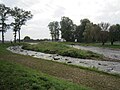
Reconstruction of the division of the hare at the former Quakenbrück rifle station
Assault hare after the conversion of the hare assault into a sole slide


Due to a planning approval decision of March 23, 2015, the dams of the Upscale Hase between Gehrde and Quakenbrück are to be rebuilt over a length of 6.5 km due to insufficient stability. They are to be widened with flatter embankments and increased in sections, and maintenance and defense routes are to be maintained on the landside. To ensure the maximum permissible water level in the Upscale Hase, two overflow sections are provided on the right-hand side in the dams and dykes to divert high water into the adjacent area.
Water quality
In 1840, Carl Heinrich Nieberding distinguished the water that flows from the east into the Hasedelta from that of the Osnabrück region:
- “ Before the merging of the Haase camps and the Haase coming from Osnabrück, one notices a big difference in the water of both rivers. Consisting of the bog areas springing or water collecting on the former retains the brownish, like the marsh water color, is harder and the grass growth may not be suitable for Beflößung the meadows and promotion, than that from the lime and Lehmgebirgen the Osnabrück country springing fertile areas by flowing Water from the Osnabrücker Haase, which is also lighter in color and softer, and therefore more useful for floating meadows. And even if the poor quality of the water from the Haase camps is alleviated by the inflow from the sand springs in the parishes of Damme , Holdorf , Steinfeld and Lohne , it is not suitable for paper manufacture, but the water from the Osnabrücker Haase is. "
In their 2004 pilot report, the Weser-Ems district government and the NLWKN stated about the sandy tributaries to the Middle Hase:
- “ The structurally better bodies of water are Eggermühlenbach , Ueffeler Aue , Reitbach and Strautbach , which, in combination with the better quality sections of the Eggermühlenbach, Bühner Bach, Ueffeler Aue and Renslager Canal, allow a relatively good assessment. Also Nonnenbach , Wrau and Möllwiesenbach be positive. This pleasing picture is expressed by the waters of Bakumer Bach , Dinklager Mühlenbach , Aue and Bokerner Bach with high quality losses. Structural and material burdens squeeze in Bakumer- and block Mühlebach an overall rating of this water body groups. "
Individual evidence
- ↑ Lower Saxony State Agency for Water Management, Coastal Protection and Nature Conservation (NLWKN): Explanatory report on the plan for the renewal of the dams and dykes on the Upscale Hase between Quakenbrück and Gehrde in the Osnabrück district . October 2013. p. 9
- ↑ Nature and Geopark terra.vita: FFH area “ Bächen im Artland” ( Memento of the original from March 5, 2016 in the Internet Archive ) Info: The archive link has been inserted automatically and has not yet been checked. Please check the original and archive link according to the instructions and then remove this notice. . P. 6f.
- ↑ Horst Neumann: Hydrological data on the hare and its catchment area with 4 tables . Osnabrück natural science communications . 1976, p. 11
- ↑ Lower Saxony State Agency for Water Management, Coastal Protection and Nature Conservation (NLWKN): Explanatory report on the plan for the renewal of the dams and dykes on the Upscale Hase between Quakenbrück and Gehrde in the Osnabrück district . October 2013. p. 9
- ↑ Lower Saxony State Agency for Water Management, Coastal Protection and Nature Conservation (NLWKN): Explanatory report on the plan for the renewal of the dams and dykes on the Upscale Hase between Quakenbrück and Gehrde in the Osnabrück district . October 2013. p. 10
- ↑ Lower Saxony State Agency for Water Management, Coastal Protection and Nature Conservation (NLWKN): Explanatory report on the plan for the renewal of the dams and dykes on the Upscale Hase between Quakenbrück and Gehrde in the Osnabrück district . October 2013. p. 11
- ↑ Lower Saxony State Agency for Water Management, Coastal Protection and Nature Conservation (NLWKN): Explanatory report on the plan for the renewal of the dams and dykes on the Upscale Hase between Quakenbrück and Gehrde in the Osnabrück district . October 2013, p. 10
- ^ Carl Heinrich Nieberding: History of the former Niederstift Munster and the adjacent counties . 1st volume. CH Fauvel, Vechta 1840, p. 8f. ( online )
- ^ Lower Saxony Ministry for Climate, Energy and Environmental Protection: Area directory for the Lower Saxony hydrographic map . P. 15
- ^ Carl Heinrich Nieberding: History of the former Niederstift Munster and the adjacent counties . 1st volume. CH Fauvel, Vechta 1840, p. 9 ( online )
- ↑ Lower Saxony State Agency for Water Management, Coastal Protection and Nature Conservation (NLWKN): Water body data sheet for waters with priority 3 . November 2012
- ^ Franz von Reden: The Kingdom of Hanover, described statistically, initially in relation to agriculture, trade and commerce, Volume 2 . Hahn'sche Hofbuchhandlung. Hanover 1839. p. 366
- ↑ Lower Saxony State Office for Water Management, Coastal Protection and Nature Conservation: Water body data sheet for waters with priority 3rd Hahnenmoorkanal . November 2012
- ^ Wilhelm Müller-Wille: Floor sculpture and natural spaces in Westphalia . 1966. p. 266
- ↑ Lower Saxony State Agency for Water Management, Coastal Protection and Nature Conservation (NLWKN): Regional structural quality report of the NLWK operating center Cloppenburg 2000 p. 30
- ↑ Heimatbund for the Oldenburger Münsterland: Essen - excerpt from LeCoq's map from 1805
- ↑ Heimatbund for the Oldenburger Münsterland: Löningen - excerpt from LeCoq's map from 1805
- ↑ Refurbishment of five locks can start Neue Osnabrücker Zeitung . January 9, 2002
- ↑ Quakenbrück: “Red lock” in the rabbit torn down . New Osnabrück newspaper . 17th January 2014
- ↑ Lower Saxony State Agency for Water Management, Coastal Protection and Nature Conservation (NLWKN): Explanatory report on the plan for the renewal of the dams and dykes on the Upscale Hase between Quakenbrück and Gehrde in the Osnabrück district . October 2013. p. 11
- ^ Lower Saxony State Agency for Water Management, Coastal Protection and Nature Conservation (NLWKN): Upscale Hare. Soil evaluation and feasibility study taking into account the subsoil conditions and the hydrodynamic boundary conditions for the project renewal of the reservoir dams and river dikes on the Upper Hase . March 25, 2013, p. 32
- ↑ Lower Saxony State Agency for Water Management, Coastal Protection and Nature Conservation (NLWKN): Dam renovation on the Upscale Hase. Hydraulic calculations . August 15, 2013. p. 5
- ^ Lower Saxony State Agency for Water Management, Coastal Protection and Nature Conservation (NLWKN): Upscale Hare. Soil evaluation and feasibility study taking into account the subsoil conditions and the hydrodynamic boundary conditions for the project renewal of the reservoir dams and river dikes on the Upper Hase . March 25, 2013, p. 40
- ↑ Artland-Gymnasium: Quakenbrück water and nature trail
- ↑ Bezirksregierung Weser-Ems / NLWKN: Inventory of the implementation of the EU Water Framework Directive. Surface waters - Hase processing area - . 2004. p. 9
- ↑ Association for the Revitalization of Haseauen: Haseauen-trail in Löningen-Brock height
- ↑ Association for the Revitalization of Haseauen: revitalizing the Essen channel
- ↑ Lower Saxony State Agency for Water Management, Coastal Protection and Nature Conservation (NLKW): Dammerung Upscale Hare . 2015
- ^ Carl Heinrich Nieberding: History of the former Niederstift Munster and the adjacent counties . 1st volume. CH Fauvel, Vechta 1840, p. 10f. ( online )
- ↑ Bezirksregierung Weser-Ems / NLWKN: Inventory of the implementation of the EU Water Framework Directive. Surface waters - Hase processing area - . 2004. p. 20
- ↑ cf. also Lower Saxony State Office for Water Management, Coastal and Nature Conservation (NLWKN) Meppen office: International management plan according to Article 13 of the Water Framework Directive for the Ems river basin district 2010-2015 ( Memento of the original from October 22, 2014 in the Internet Archive ) Info: The archive link was automatically inserted and not yet checked. Please check the original and archive link according to the instructions and then remove this notice. . 2009. pp. 189 and 229f.