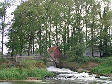
Ambush hare
The attack hare is a section of the Hase near Quakenbrück in the Lower Saxony district of Osnabrück, which begins near the former Hase attack (Schützenhofwehr) and ends at the inflow of the Bünne-Wehdeler Grenzkanal . It is a body of water in the inland delta of the Hase and forms part of the water system of the Großer Hase , which flows around Quakenbrück in the east and north.
Name and story
The name raid hare comes from the time when there was still a weir at the junction of the hare arm, which was called hare attack . At this point the hare fell down a small waterfall . In 2013, the waterfall was replaced by the sole slide to enable fish and other aquatic organisms to climb into the hare, which was previously dammed up by the weir and still raised above the current sole slide (on the same level).
course
The attack hare branches off ( ⊙ ) near the Quakenbrücker Schützenhof a few meters south of the former hare attack ( ⊙ ) from the hare pent up here towards the north, from where your water flows with an initially steep gradient over a 200 m long and 30 m wide invert . After about 1.7 km of flow, the Wrau , which flows parallel to it, flows into the attack hare ( ⊙ ) . It ends at the inflow of the Bünne-Wehdeler Grenzkanal ( ⊙ ). Downstream from this point the body of water is called the Essen Canal .
purpose
As with comparable hydraulic engineering projects since the 18th century, the main purpose of the artificial drainage of the water into the attack hare is to protect the town of Quakenbrück from flooding by diverting parts of the hare. The protection of agricultural areas from flooding was not the main focus when creating this arm of the hare, as agriculture in Artland used to owe its prosperity primarily to the regular flooding of the usable areas.
Individual evidence
- ↑ Lower Saxony State Agency for Water Management, Coastal Protection and Nature Conservation (NLWKN): So that fish can migrate: Quakenbrück Schützenhof weir is being rebuilt . Press release. April 11, 2013
- ↑ Quakenbrück: Sohl slide instead of weir at the Schützenhof , in: Neue Osnabrücker Zeitung , from April 18, 2011
- ↑ Lower Saxony State Agency for Water Management, Coastal Protection and Nature Conservation (NLWKN): Determination of the floodplain of the Raid Hare, the Essen Canal and the Great Hare ( Memento from October 17, 2014 in the Internet Archive ). Appendix 2-8 (site plan). August 27, 2014
- ^ Lower Saxony Ministry for Climate, Energy and Environmental Protection: Area directory for the Lower Saxony hydrographic map . P. 15

