
Goodness
| Goodness | ||
 Dütequelle |
||
| Data | ||
| Water code | EN : 362 | |
| location | Germany , western Lower Saxony | |
| River system | Ems | |
| Drain over | Hase → Ems → North Sea | |
| source | in the Teutoburg Forest , east of Bad Iburg 52 ° 9 ′ 47 ″ N , 8 ° 6 ′ 49 ″ E |
|
| Source height | 199 m above sea level NHN | |
| muzzle | in Lotte in die Hase Coordinates: 52 ° 19 ′ 57 ″ N , 7 ° 57 ′ 16 ″ E 52 ° 19 ′ 57 ″ N , 7 ° 57 ′ 16 ″ E |
|
| Mouth height | 52 m above sea level NHN | |
| Height difference | 147 m | |
| Bottom slope | 4.2 ‰ | |
| length | 35 km | |
| Discharge at gauge Wersen A Eo : 228 km² Location: 1.5 km above the mouth |
NNQ (07/21/1964) MNQ 1958/2008 MQ 1958/2008 Mq 1958/2008 MHQ 1958/2008 HHQ (06/30/1981) |
110 l / s 577 l / s 2.53 m³ / s 11.1 l / (s km²) 27.7 m³ / s 73.1 m³ / s |
| Left tributaries | Schlochterbach, Wilkenbach, Goldbach , Hischebach | |
| Big cities | Osnabrück | |
| Small towns | Georgsmarienhütte | |
| Communities | Hilter am Teutoburg Forest , Oesede Monastery, Oesede , Holzhausen , Sutthausen , Hellern , Atter , Lotte | |
The Düte is a mountainous body of water. It rises on the southern slope of the Teutoburg Forest on the Hohnsberg near the Großer Freeden in Bad Iburg .
course
From its source between Wellendorf and Bad Iburg, the Düte runs via Oesede Monastery , straightened along the railway line to Georgsmarienhütte , passes a sewage treatment plant in Malbergen and flows from there through a meadow valley via Hörne to Osnabrück . In Lotte it flows into the Hase after a distance of approx. 35 km .

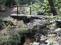
Upper course of the Düte, north of the Hohnsberg
The left tributary of the Düte, the Schlochterbach, at the border triangle


Water structure quality
In the upper reaches to the rain retention basin at Kloster Oesede, the Düte runs largely near-natural for the first five kilometers ( water structure quality 1 to 3), in some cases significantly changed (quality class 4). At Kloster Oesede the structural quality changes to class 6 (very much changed), at Georgsmarienhütte to class 7 (completely changed) due to the piped laying under the company premises of the steelworks . North of Georgsmarienhütte, the water situation then relaxes again.
Landscape image
The upper Düte is characterized by unchanged, natural sections and short bank reinforcements. In narrow valleys the Düte often runs through deciduous forest , otherwise grassland dominates in the floodplain and alder trees line the water. The more than one kilometer long underground piping under the company premises of the steelworks represents a complete separation of the upper course from the lower course. The lower course itself then has a natural curve, the Düte meanders , mostly lined with alders, through a meadow valley. At Hörne, the Düte is uneven, lined with wood on the banks, and the banks are only occasionally blocked by stone pouring or other fortifications. Below Hellern , the Düte is again expanded and partially straightened. In the Atter district , the federal motorway 1 crosses the Düte.
Nature reserve
In the landscape framework plan of the city of Osnabrück, the Düte is recommended as a potential nature reserve . A revitalization concept in the Düte landscape plan aims to develop the Düte into a natural flowing water, so that the river bed and floodplain can once again become a habitat for flora and fauna typical of the water. The city of Osnabrück is making around 47 hectares available for this purpose, which is to be exchanged for areas that will be used to create strips of waterways and to extend their use in the future floodplain.
Web links
- Water quality map from NLWKN
- Peace City Osnabrück - Düte Tour
- 3613-332 Düte with tributaries. (FFH area) Profiles of the Natura 2000 areas. Published by the Federal Agency for Nature Conservation .
Individual evidence
- ^ Deutsches Gewässerkundliches Jahrbuch Weser-Ems 2008 Lower Saxony State Agency for Water Management, Coastal Protection and Nature Conservation, accessed on January 22, 2016 (PDF, German, 6184 kB).
- ↑ Horst Troiza: Hase tributary: 35 kilometers, six water quality classes . In: noz.de. March 27, 2014, accessed October 12, 2016 .
- ↑ City of Osnabrück: Düte with tributaries. In: osnabrueck.de. Retrieved October 12, 2016 .
- ↑ City of Osnabrück: The goodness. In: osnabrueck.de. Retrieved October 12, 2016 .