
Atter
|
|||
|---|---|---|---|
Map:
|
|||
| Basic data | |||
| Area : | 10.67 km² | ||
| Residents : | 4278 (December 31, 2019) | ||
| Population density : | 402 inhabitants / km² | ||
| Postal code : | 49076 | ||
| Primaries : | 0541 | ||
| structure | |||
| District number: |
19th |
||

Atter is a district in the west of Osnabrück (Lower Saxony). The district had 4,278 inhabitants at the end of 2019. It covers an area of 1,067.4 hectares. The population density of 402 inhabitants / km² is the lowest of all Osnabrück districts. Atter was incorporated into Osnabrück on July 1, 1972.
Spatial structure
Atter border the districts of Eversburg in the northeast, Westerberg in the southeast and Hellern in the south. In the west, Atter borders the North Rhine-Westphalian community Lotte , where Autobahn 1 also crosses the district. Historically, the border with Eversburg is the Eversburger Landwehrgraben , while the border with Westerberg runs through the Rubbenbruchsee in a recreational area . In the north-west of Atter, on the border with Lotte, lies the Attersee . The most important flowing water in Atter is the Düte , which is bordered by natural floodplains.
The residential development of the district is divided into three main settlements : the Atteraner town center, the Atterfeld settlement in the south and the Strothesiedlung and the future Landwehr district in the northeast. In between there are mainly agricultural areas and forests. The Atters area, which is north of the Löhne – Rheine railway line near Autobahn 1, is characterized by commercial activities.
history
Mayor of the former municipality of Atter
- 1933–1945 Giesbert Bergerhoff (NSDAP)
- 19 ?? - 1952 Heinrich Hasemeyer (SPD)
- 1952–1956 Giesbert Bergerhoff (UWG)
- 1956–1966 Heinrich Hasemeyer (SPD)
Population development
The population development of the Atter district:
|
|
|
|
Buildings
The Evangelical Lutheran Stephanuskirche and Gut Leye with a Roman Catholic chapel still exist today, while the Evangelical Reformed Atterkirche was closed due to financial shortages. The district meeting place Wir in Atter is based in the building today . The Atter cemetery, about 10,000 m² in size, is the smallest cemetery in Osnabrück. It is located in Leyer Holz north of the district center and was laid out in 1913.
An important traffic structure in Atter is the Dütebrücke , on which the Autobahn 1 crosses the Löhne – Rheine railway line and the Düte. Since the bridge has reached the end of its service life, it has been rebuilt since 2017.

Good Leye

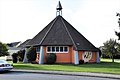
Stephanuskirche
District meeting place We in Atter , former Atterkirche


conversion
The former barracks area of the Quebec Barracks in the northeast of Atter is 370,410 m². The headquarters of the British Armed Forces in Germany (formerly the British Army of the Rhine ) was located in the barracks on Landwehrstrasse, which was abandoned in 2008 . Also 107 residential units outside the barracks, mostly from the 1950s and 1960s, were used by members of the British armed forces.
As part of conversion measures , a new residential area is to be built on the former barracks site under the project title Landwehrviertel . Between 2017 and 2022, up to 800 residential units for up to 2500 people are to be built, making the Landwehrviertel the largest development area in Osnabrück since the Second World War. Some buildings from the period of use by the military (e.g. a sports hall complex) and a grassland biotope in the west of the site are to be retained. In addition to the residential development, the Landwehrviertel will also include a supermarket, a daycare center, a central park and a public transport link.
Transport links
Atter is on the federal motorway 1 and can be reached via the Osnabrück-Hafen junction. Atter is the only airfield in Osnabrück with the Osnabrück-Atterheide airfield.
On the outskirts of Atter, but already in North Rhine-Westphalian territory, there was formerly Lotte station on the Löhne – Rheine railway line , to which Atter Bahnhofstrasse still refers to today. In 1949 Atter was also connected to Osnabrück's first trolleybus line , which ran with a tram connection from Rißmüllerplatz via Natruper Straße to Eversburg-Atter and another sub-line to Eversburg-Büren (→ local transport in Osnabrück ). Today Atter is served by city buses on lines M2 and 17.
Web links
Individual evidence
- ↑ Municipal statistics and monitoring portal Osnabrück (KOSMOS): Population - residents with main residence , osnabrueck.de, accessed on August 3, 2019
- ↑ City of Osnabrück, Statistics 11/2011 (PDF file)
- ↑ Population development since 1861 (PDF file)
- ^ In the Neue Osnabrücker Zeitung on August 1, 2012: "Lust and burden of the architectural monument"
- ↑ https://www.noz.de/lokales/osnabrueck/artikel/951495/diskussion-um-politisch-RLete-strassennamen-in-osnabrueck In Neue Osnabrücker Zeitung on September 14, 2017: "Discussion about politically polluted street names in Osnabrück ": accessed October 4, 2018
- ↑ https://www.noz.de/lokales/osnabrueck/artikel/1017696/stadt-osnabrueck-benennt-historisch-RLete-strassen-um In Neue Osnabrücker Zeitung on February 8, 2018: "City of Osnabrück renames historically polluted streets "; accessed on October 4, 2018
- ↑ In Neuer Osnabrücker Zeitung on January 25, 2013: "Heinrich-Hasemeier-Strasse commemorates the long-time mayor of Atter"
- ↑ City of Osnabrück, statistics, population by district 2004 - 2014 (PDF file)
- ↑ https://geo.osnabrueck.de/kosmos/bericht_daten_statistik/atlas.html?select=Stadtstrich KOSMOS - Municipal Statistics and Monitoring Portal Osnabrück Figures 2014 - 2019
- ↑ Atter cemetery
- ↑ Quebec Barracks ( Memento of the original from November 9, 2010 in the Internet Archive ) Info: The archive link was inserted automatically and has not yet been checked. Please check the original and archive link according to the instructions and then remove this notice. on the website of the Federal Agency for Real Estate Tasks
- ^ Locations of former British residential quarters in Osnabrück , osnabrueck.de
- ↑ The Quebec Barracks become the Landwehrviertel , osnabrueck.de
- ↑ Das Landwehrviertel (interactive report) , noz.de, accessed on April 19, 2017
Atter | Therefore / Gretesch / Lüstringen | Dodesheide | Eversburg | Fledder | Garden location | Port | Haste | Lightening | Downtown | Limestone hill | Nahne | Pye | Schinkel | Schinkel-Ost | Schölerberg | Sun hill | Sutthausen | Voxtrup | Westerberg | Weststadt | Widukindland | desert
Coordinates: 52 ° 18 ' N , 7 ° 57' E